
 Worksheets
Unit 3-U.S. & Canada Test Review
Total questions: 25
Worksheet time: 25mins

Use the physical map provided and your knowledge of the major landforms of the U.S. & Canada to identify the two physical features that were created by tectonic activity.
Rocky Mountains and Appalachian Mountains
Great Plains and Canadian Shield
Mississippi River and Great Lakes
Appalachian Mountains and Interior Plains

Using the climate map above, which region of the United States is known for having a Mediterranean climate, characterized by hot, dry summers and mild, wet winters?
Southeastern United States
Southwestern United States
Pacific Coast of California
Northeastern United States
The Canadian Shield, a vast area of ancient rock, is found primarily in which part of Canada?
Eastern Canada
Central and Northeastern Canada
Southern Canada
Western Canada

Mexico City in central Mexico is closer to the equator than Houston, TX. Its average summer temperatures are cooler than Houston’s. What best explains this?
Mexico City has a higher elevation than Houston.
The use of air conditioners has raised temperatures in Houston.
Mexico City is subject to periodic storms, lowering temperatures
Mexico City is farther from the Gulf of Mexico than Houston.
How does the occurrence of El Niño influence weather patterns in the United States and Canada?
El Niño typically brings warmer winters to Canada and increased rainfall to the southern United States.
El Niño results in cooler temperatures across the entire United States and Canada.
El Niño has no significant effect on the weather patterns of North America.
El Niño causes severe droughts across both the United States and Canada.

Using the map above and your knowledge of geography which factors would lead to the location of most of Canada’s factories?
Polar climate, access to Hudson Bay and large First Nations populations
Temperate climate, access to railroads and canals, and urban populations
Natural resources, interior location, rural populations
Infrastructure, coastal locations, undefined populations
How do the Rocky Mountains differ from the Appalachian Mountains?
The Rocky Mountains run north to south and the Appalachians run east to west.
The Rocky Mountains are older than the Appalachians and have been much more worn down by the elements over time.
The Rocky Mountains rise to much lower elevations than the Appalachians.
The Appalachians are older than the Rocky Mountains and are more weathered.
Which type of economic system is used in the United States, where individuals and businesses make most of the economic decisions?
Command economy
Socialist economy
Traditional economy
Free-Enterprise economy
Which type of government do both the United States and Canada have?
Monarchy
Dictatorship
Federal republic
Democracy
In Canada, which position serves as the Head of State in place of the King or Queen?
Premier
Governor-General
Prime Minister
Chief Justice
What is the most commonly spoken language in the United States?
Spanish
French
English
Chinese
In which province of Canada is French the official language?
Ontario
Alberta
Quebec
British Columbia
Which religion has the largest number of followers in both the United States and Canada?
Islam
Judaism
Hinduism
Christianity
Considering the higher GDP per capita in the United States compared to Canada, which of the following might best explain why the Human Development Index (HDI) scores of both countries are relatively close?
Canada has more advanced technology industries.
The HDI also factors in education and life expectancy, not just income.
The United States has a larger population, impacting HDI.
Canada invests more in international aid and trade agreements.
Which of the following is a common "pull factor" that encourages people to migrate to the United States or Canada?
War and conflict in home countries
Environmental disasters
Higher wages and better job opportunities
High crime rates in home countries
Which of the following is an example of a "push factor" in migration?
Better job opportunities
Lack of access to healthcare
Higher wages
Availability of educational institutions
How do the major economic activities of the Great Plains region of the United States and Canada impact their economies?
Agriculture is a dominant activity, providing both countries with essential crops for export and domestic consumption.
Tourism drives most of the economy, leading to population growth in rural areas.
The region relies on manufacturing, which helps build strong industries in both countries.
The region focuses on technology, which leads to the development of urban centers.
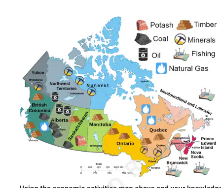
Using the economic activities map above and your knowledge of geography, what is the primary economic activity in the Canadian province of Alberta?
Agriculture
Tourism
Oil and natural gas extraction
Manufacturing

Using the climate graph above, what climate zone is Churchill Canada most likely located in?
Humid Continental
Arid
Subarctic
Humid Subtropical
How does the USMCA trade agreement affect trade between the United States, Canada, and Mexico?
It eliminates all tariffs on agricultural products only.
It encourages more trade by reducing tariffs and trade barriers on goods and services.
It limits trade to protect domestic industries in all three countries.
It focuses solely on increasing exports from the United States.

Which of the following is an observation about the population distribution in the US & Canada region, and a factor influencing it?
Most people live near the US-Canada border due to milder climate and economic opportunities.
Most people live in the northern parts due to colder weather and fewer cities.
Population is evenly spread across both countries because of similar geography everywhere.
Most people live in rural areas because of abundant farmland.
How does latitude impact precipitation patterns in the United States?
Coastal regions always receive more rainfall
Southern latitudes tend to have warmer, more humid climates
Northern latitudes have consistent precipitation
Latitude has no significant impact on precipitation
In comparing Canada and the United States, which of the factors below would contribute most to their high HDI rankings?
Advanced healthcare and education systems
Population size
Natural resource abundance
Military strength
Which of the push factors below most significantly influences migration from rural to urban areas in North America?
Political instability
Economic opportunities and job availability
Climate change
Religious persecution
In a free enterprise system like in the United States, how do supply and demand primarily influence the system?
Government sets all prices
Prices remain constant regardless of market conditions
Prices are determined by consumer demand and product availability
Producers always control product pricing

