
 Worksheets
North America review
Total questions: 18
Worksheet time: 9mins
Name
Class
Date
1.
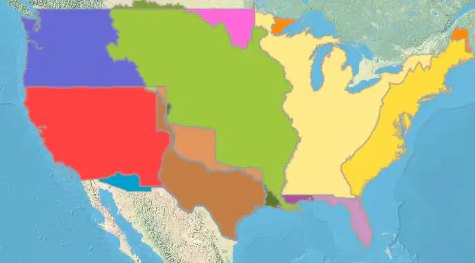
Without this purchase in 1803, everything West of the Mississippi would have never been settled. We would also not have fulfilled our "Manifest Destiny"
a)
France
b)
Spain
c)
England
d)
Germany
2.
Native Americans once held 100% of the land in The USA, now they have
a)
3%
b)
10%
c)
15%
d)
25%
3.

According to this chart, what are the 3 most commonly spoken languages in the USA by ranking (#)
a)
English, French, Chinese
b)
English, French, Arabic
c)
English, Spanish, Arabic
d)
English, Spanish, French
4.
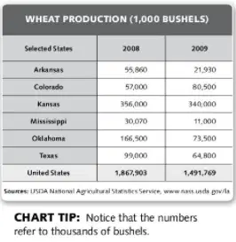
According to the chart, how does Colorado's wheat production in 2009 compare to the other states?
a)
Largest producer in the country
b)
only state whose production went up
c)
had a large drop in production
d)
produced less wheat than Texas
5.
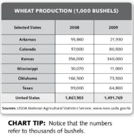
According to the chart, what happened to the U.S. wheat production from 2008 to 2009?
a)
nearly doubled in size
b)
went down in 2009
c)
rose somewhat in 2009
d)
stayed the same both years
6.

The _______ Ocean is on the eastern side of North America, while the _______ Ocean is on the western side
a)
Atlantic; Pacific
b)
Pacific; Atlantic
c)
Atlantic; Southern
d)
Pacific; Southern
7.
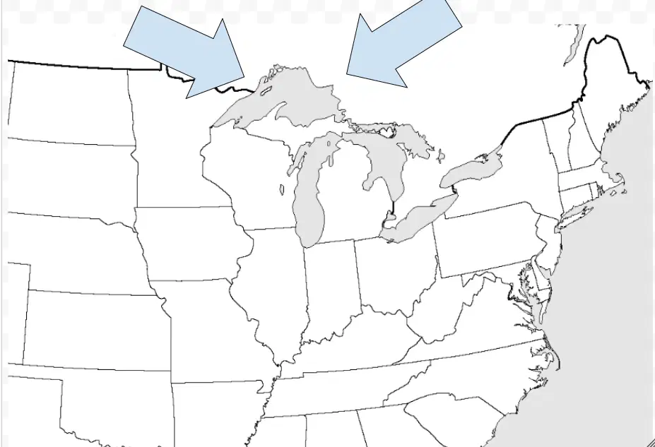
The largest fresh water lake in the world, and the largest of the Great lakes, is
a)
Lake Huron
b)
Lake Erie
c)
Lake Michigan
d)
Lake Superior
e)
Lake Ontario
8.

What mountain range can be seen in green here?
a)
Rocky Mountains
b)
Sierra Madre Mountains
c)
Sierra Nevada Mountains
d)
Appalachian Mountains
9.
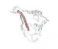
What mountain range can be seen in green here?
a)
Rocky Mountains
b)
Sierra Madre Mountains
c)
Sierra Nevada Mountains
d)
Appalachian Mountains
10.

Which region has the population density highest on this map?
a)
Northeast & Southeast
b)
West & Midwest
c)
Northwest & West
d)
Southwest and West
11.
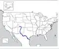
Large river that forms a border between the US and Mexico
a)
The Great Lakes
b)
Mississippi River
c)
Rio Grade River
12.

Which region is being shown with these states on the chart?
a)
Northeast
b)
Midwest
c)
West
d)
Southwest
13.

Find the scale on this map.
a)
Top right
b)
Top left
c)
Bottom right
d)
Bottom left
14.
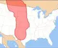
Which Biome is found in the Great Plains?
a)
Rainforest
b)
Desert
c)
Grassland
d)
Tundra
15.

In what direction has the center of population for the US been moving over time?
a)
East
b)
West
c)
South
d)
North
16.

Which lines are being shown on the globe below?
a)
Longitude
b)
Attitude
c)
Latitude
d)
Platitude
17.

Which lines on a map measure east & west in degrees?
a)
Latitude
b)
Magnitude
c)
Longitude
d)
Platitude
18.
What is the study of mapmaking called?
a)
Cartography
b)
Mapography
c)
Geography
d)
Mapology
100 %

