
 Worksheets
Earth Science Unit 2 Atmosphere
Total questions: 25
Worksheet time: 13mins
Name
Class
Date
1.
In which layer of the atmosphere does temperature increase as altitude increases?
a)
Thermosphere and Troposphere
b)
Troposphere and Mesosphere
c)
Mesosphere and Thermosphere
d)
Stratosphere and Thermosphere
2.
What causes La Nina?
a)
Cooling water off the Atlantic Coast of the USA
b)
Cooling of water in the Atlantic Ocean off the coast of South America
c)
Warm Pacific waters off the West coast of the Americas are pushed by trade winds
d)
Cooling of water in the Atlantic Ocean off the coast of North America
3.
La Niña will cause what kind of weather in the southeastern US?
a)
cold and wet
b)
cold and dry
c)
warm and wet
d)
warm and dry
4.
Albedo refers to an object's ability to ______ solar radiation
a)
Absorb
b)
Reflect
5.
Prevailing winds that blow throughout the contiguous United States (found between the 30 o and 60 o latitudes) are called
a)
trade winds
b)
westerlies
c)
doldrums
d)
polar easterlies
6.
The warming of the surface and lower atmosphere of Earth that occurs when carbon dioxide, water vapor, and other gases in the air absorb and reradiate infrared radiation is known as ...
a)
radiation.
b)
electromagnetic energy.
c)
greenhouse effect.
d)
thermal heat.
7.
_______ refers to short-term conditions that happen in an area. __________ uses an area's average precipitation and rainfall to determine long-term conditions.
a)
Weather, Climate
b)
Climate, Weather
8.
In general, the Coriolis effect is noticeable only on objects that move very fast or travel
a)
from north to south.
b)
along a wind belt.
c)
long distances.
d)
during daylight hours.
9.
Humid conditions are caused by which of the following air masses?
a)
Polar
b)
Tropical
c)
Maritime
d)
Continental
10.
Which of the following explains why the air cools as you rise up in the troposphere, but not the stratosphere.
a)
Hot air from global wind patterns rises until it reacher the stratosphere, where hot ait is trapped and bounces around in the ozone layer
b)
Earth's surface reflects ultraviolet radiation, as you get further away in the troposphere it gets cooler. The stratosphere blocks that absorbed heat from leaving the atmosphere, which is why it gets warmer.
c)
Earth's surface radiates thermal energy. As you further away in the troposphere, the atmosphere thins, which reduces its ability to trap heat. The stratosphere contains the ozone layer, which absorbs ultraviolet radiation.
d)
The clouds in the stratosphere prevent heat from entering which makes toe troposphere colder and heats up the stratosphere.
11.

The arrows on the two maps below show how the monsoon winds over India change direction with the seasons.
a)
Summer is cooler and less humid than winter
b)
Summer is warmer and more humid than winter
c)
Winter is cooler and more humid than summer
d)
Winter is warmer and less humid than summer
12.
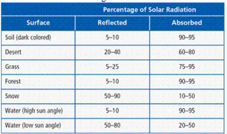
Which surface has the highest albedo?
a)
Water (high sun angle)
b)
Water (low sun angle)
c)
Snow
d)
Desert
13.
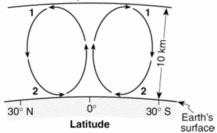
The cross section below shows the general movement of air within a portion of Earth’s atmosphere located between 30ºN and 30ºS latitude. Numbers 1 and 2 represent different locations in the atmosphere. The air movement shown in the cross section is due to the process of what?
a)
convection.
b)
evaporation.
c)
condensation.
d)
conduction.
14.
Most of Earth's weather events take place in the
a)
Thermosphere
b)
Stratosphere
c)
Mesosphere
d)
Troposphere
15.
Where do most hurricanes develop?
a)
over cold, polar oceans
b)
over warm, tropical continents
c)
over warm, tropical oceans
d)
over cold, polar continents
16.
What kind of weather can be expected when a cold front moves through an area?
a)
Warm temperatures, light precipitation
b)
Warm temperatures, heavy precipitation (possible thunderstorms)
c)
Cool temperatures, heavy precipitation (possible thunderstorms)
d)
Cool temperatures, light precipitation
17.
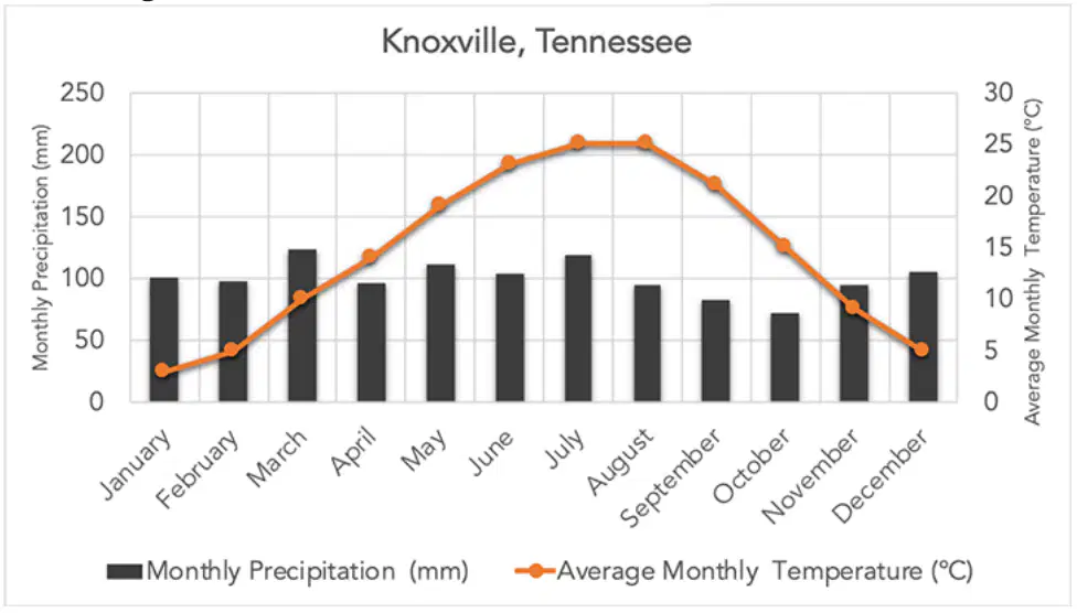
A climatogram for Knoxville, TN is shown below. Based on the climatogram for Knoxville, TN, which of the following is true?
a)
The amount of precipitation increases during the summer months
b)
The amount of precipitation decreases during the summer months
c)
Precipitation is not shown on this graph
d)
The amount of precipitation stays relatively stable throughout the year
18.
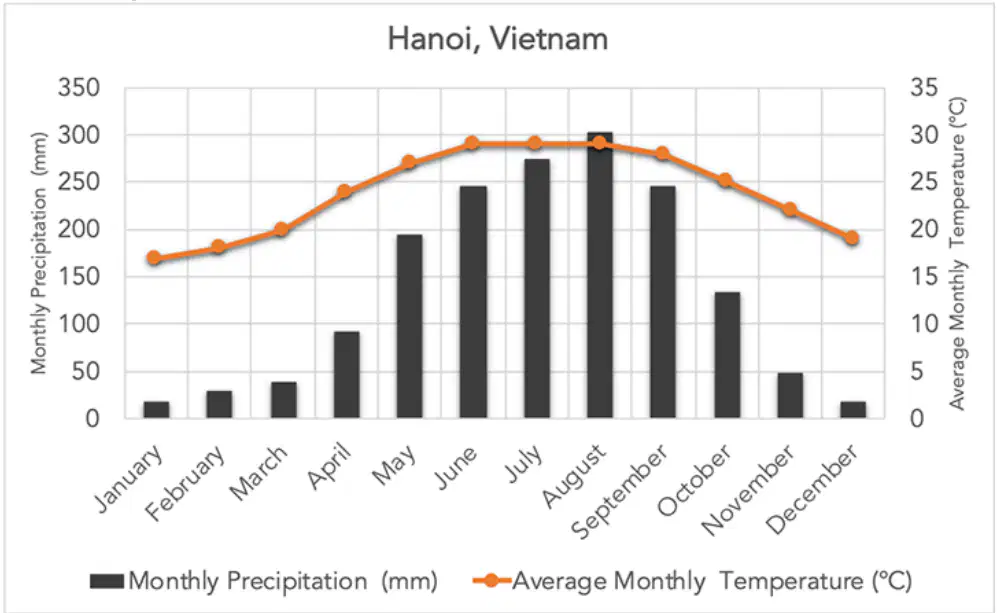
A climatogram for Hanoi, Vietnam is shown below. Using the graph, which of the following statements are true?
a)
Vietnam experiences extreme fluctuations between high and low temperatures throughout the year.
b)
Vietnam experiences no change in temperatures throughout the year.
c)
The amount of precipitation in Vietnam stays relatively stable throughout the year.
d)
Vietnam experiences a season with relatively heavy amounts of precipotation and a season with a relatively low amount of precipitation
19.
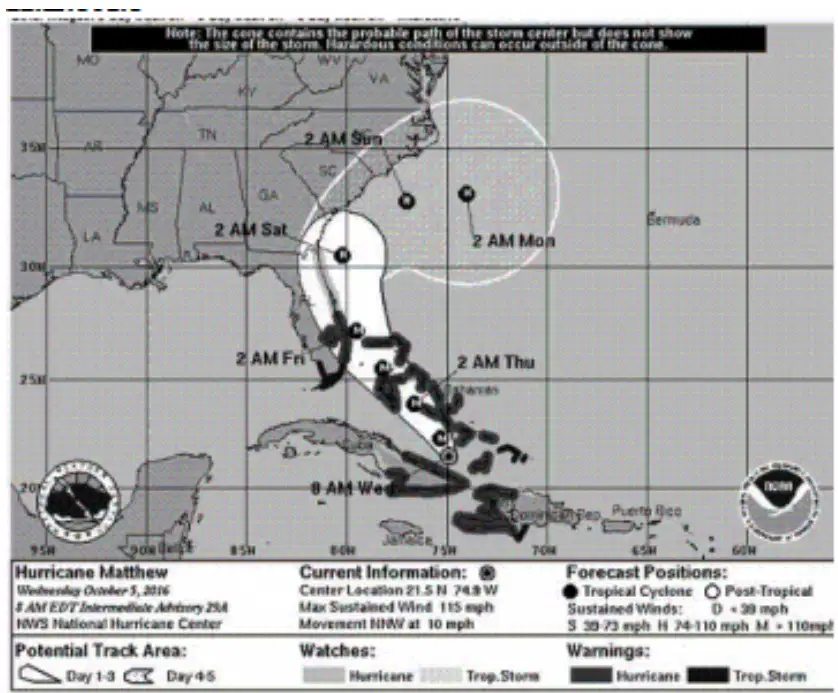
The picture below shows one of the predicted paths that Hurricane Matthew would take in October 2016. Which of the following is an explanation as to why hurricanes tend to move off the coast of the United States toward the Atlantic Ocean as they move further north of 30°N latitude?
a)
It becomes too cold for hurricanes to exist ablve 30' N latitude
b)
The presence of land forces the hurricane to flow back out to sea
c)
Between 30-60°N latitude, global winds blow weather systems from the west to the east
d)
Hurricanes turn into tornadoes when they move onto land
20.
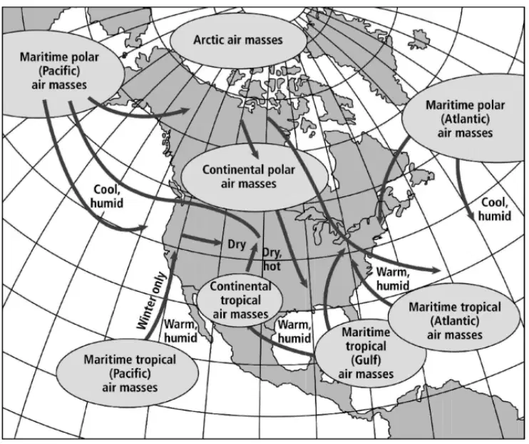
The map below shows North American air-mass source regions, the resulting air-mass names, and typical air-mass tracks. A maritime polar air mass approaching Maine would most likely bring
a)
warm, dry air from the southeast
b)
warm, moist air from the south
c)
cool, moist air from the north
d)
cool, dry air from the southeast
21.
A front that forms when a cold air mass overtakes a warm air mass and lifts the warm air mass off the ground and over another air mass is called a(n)
a)
warm front.
b)
cold front.
c)
stationary front
d)
occuluded front
22.
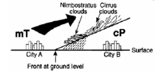
The diagram below shows the frontal boundary between mT and cP air masses. Using what you know about these types of air masses, if the front at ground level is moving towards city B, which type of weather front is shown?
a)
cold front
b)
warm front
c)
occluded front
d)
stationary front
23.
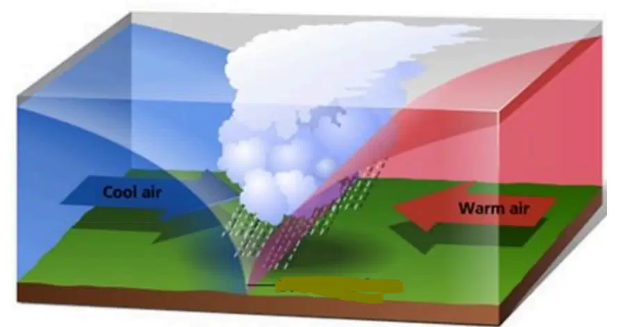
Use the image below to answer the question. Which of the following types of weather will this front bring?
a)
long periods of storms
b)
warm, dry weather
c)
cold temperatures
d)
short periods of light precipitation
24.
Where would the air contain the most moisture?
a)
over Arizona
b)
over the Rocky Mountains
c)
over the Arctic Circle
d)
Over Hawaii
25.
An instrument that measures precipitation by bouncing radio waves off rain or snow is
a)
Doppler radar.
b)
a hygrometer
c)
a rain gauge
d)
a radiosonde
100 %

