
 Worksheets
Checkpoint #1 Review
Total questions: 18
Worksheet time: 9mins
Which of the following best characterizes the way Native American tribes interacted with the environment during the era of Texas Natural and its People?
A. They developed unique ways to use local resources for food, shelter, and clothing.
B. They depended on trade with European settlers for survival.
C. They built large cities and permanent settlements throughout Texas.
D. They avoided contact with other tribes and regions.
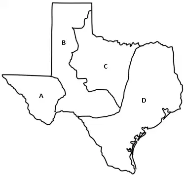
Which region does the letter D represent on this map?
Great Plains
Mountains and Basins
North Central Plains
Coastal Plains
Which region does the letter C represent on this map?
Great Plains
Mountains and Basins
North Central Plains
Coastal Plains
Which area on the map represents the Mountains and Basins region?
A
B
C
D
Which area on the map represents the region of the Great Plains?
A
B
C
D
Which region has the lowest elevation?
Great Plains
Mountains and Basins
North Central Plains
Coastal Plains
Which region has the highest elevation?
Great Plains
Mountains and Basins
North Central Plains
Coastal Plains
What famous landmarks are found in the Great Plains?
Guadalupe and Davis Mountains, Upper Rio Grande Valley, and Big Bend National Park
Palo Duro Canyon, Edwards Plateau, and Caprock Escarpment
Big Thicket National Forest, Galveston Beach, The Alamo, and NASA
ATT Stadium, Dinosaur Valley, Ft Worth Stockyards, and National Museum of the Pacific War
True or False: The natives who lived in the Great Plains were nomadic?
True
False
In which region of Texas did the natives develop irrigation systems?
Coastal Plains
Great Plains
Mountains and Basins
North Central Plains
What event marked the beginning of the Era of Contact in the history of Texas?
A. The arrival of Spanish explorers in Texas.
B. The founding of the first Anglo settlements in Texas.
Native American tribes were expelled from Texas by French settlers.
Spanish settlers abandoned the exploration of Texas after not finding gold.
In what year was San Antonio de Valero established?
1492
1628
1718
1803
What motivated Spanish leaders to send Fray Damián Massanet and Alonso De León to explore East Texas in 1690?
To locate new trade routes
To counteract French influence in the region
To establish settlements for Spanish citizens
To negotiate peace with local tribes
Why did Spain decide to strengthen its presence in eastern Texas despite the high costs of maintaining missions and presidios?
To promote trade with Native Americans
Because of improved relations with local tribes
Due to the discovery of gold in the region
To counter the threat of nearby French settlements

Select the 4 regions of Texas.
(You must choose 4)
Mountains and Basins
Great Plains
North Central Plains
Central
Coastal Plains
Why is René-Robert Cavelier Sieur de La Salle known?
To search for Cíbola
To establish the San Antonio de Valero mission
To map the coast of Texas
To land at Matagorda Bay while searching for the Mississippi River
Why did European explorers begin to search in the Americas?
to find gold
to find minerals
to escape European rule
to meet the natives
What caused Spain to become interested in establishing missions in East Texas?
Columbus landing in East Texas
La Salle's exploration
Pineda mapping the coast
Cíbola was found

