
 Worksheets
Geography Test
Total questions: 38
Worksheet time: 20mins

Navigator-
A person who plans and decides which path to travel and follow
One who draws maps
One who measure ocean tides
One who observes the night sky

Latitude-
A model of the Earth
How far a place is from the equator
How far a place is from the prime meridian
A measurement of liquid

There are _ continents.
(a)

Landforms-
globe
resources
Oceans
Masses of land such as continents, islands, and peninsulas

Globe-
A model of the Earth that is spherical
A tidal wave
A flat map
A type of compass used for navigation

Longitude-
How far a place is from the equator
A scale to tell distance
How far a place is from the prime meridian
A type of map showing oceans

What directions do the lines of latitude run?
(a)

Cartographer-
A person who plans and decides which path to travel and follow
One who designs cars
A person who explores new lands
A person who makes and draws maps

What is the largest ocean in the world?
(a)
What are one of the three mountain ranges in the United States?
Cascades
Rocky Mountains
Mt. Everest
Kilimanjaro
Map projections-
A way to show the Earth’s round shape on a flat surface
Drawing a map on a wall
A tool used to measure distance on a map
What is the largest continent in the world?
(a)
Distortion-
The process of creating a 3D model of the Earth
A way to show the Earth’s round shape on a flat surface
A type of map that only shows political boundaries
An incorrect appearance of what is shown on a map
What percentage of the Earth is covered in water?
(a)
Compass rose-
A tool used to measure distance on a map
A circular symbol on a map that shows the cardinal directions
A type A diagram that shows the size of countriesof map projection
legend/map key-
A symbol on a map that shows the cardinal directions
A line that measures distance on a map
An explanation of the symbols on a map
A type of projection used to make a map
What imaginary line divides the Northern and Southern Hemispheres?
(a)
What is the smallest continent in the world?
(a)
How many states are there in the USA?
(a)
What is the longest river in the United States?
Missouri
Colorado
Rio Grand
Mississippi
What directions do the lines of longitude run?
(a)
What are the seven continents?
Asia, Austria, Australia, Antarctica, South America, North America, Europe
Asia, Africa, Angola, Antarctica, South America, North America,
Asia, Africa, Australia, Antarctica, Greenland, North America,
Asia, Africa, Australia, Antarctica, South America, North America,

The green X marks which of the following physical features
South Padre Island
Gulf of Mexico
Caribbean Sea
Yucatan Peninsula

Which geographic feature is located at point A?
Atlantic Ocean
Mediterranean Sea
Alps
English Channel
tributary-
A type of lake formed by melting glaciers
A river that flows underground
Smaller stream that feeds into a river.
A river that flows into another river
Scale-
The relationship between the actual size of something and it’s size on a map.
An explanation of the symbols on a map
A circular symbol on a map that shows the cardinal directions
An incorrect appearance of what is shown on a map


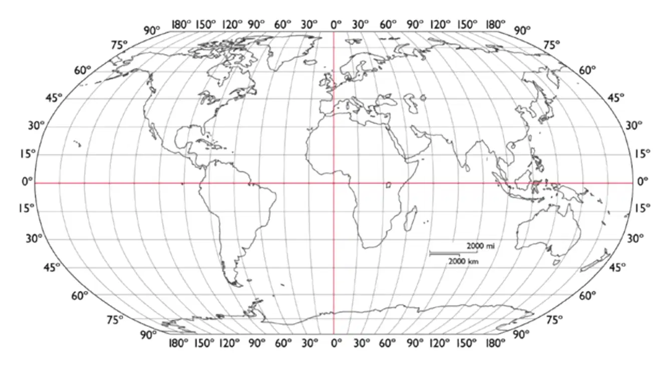


Which continent at is 50°N 15°E ?
Europe
Africa
Antarctica
North Pole


Which continent at is 86°S 130°E ?
Europe
Africa
Antarctica
North Pole

