
NEW
Font size
 Worksheets
Unit 1 - NYS Geography and Native Americans
Total questions: 20
Worksheet time: 10mins
What kind of maps might be used to show New York State's diverse geography?
Only road maps
Maps showing only cities
Maps that show different features like mountains, rivers, and
lakes
Maps showing only the weather
Which of these features is an example of New York State's
geography?
Eiffel Tower
Niagara Falls
Great Wall of China
The Taj Mahal
What is a key aspect of New York State's diverse geography
It has only forests and no other landscapes.
It has mountains, forests, lakes, rivers, and cities.
It is entirely flat without any hills.
It is a desert region with no water bodies.
Look at the map of the United States. Which map shows New York in red?


Which answer shows 2 states that border New York?
New Jersey and Vermont
Rhode Island and Canada
Maine and Michigan
Eerie and Ontario
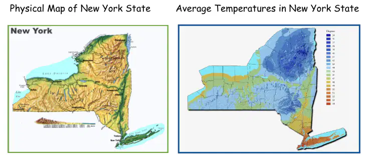
What is one similarity between these two maps?
They both show rain fall
They both show mountains
They both show New York State
They both show rivers
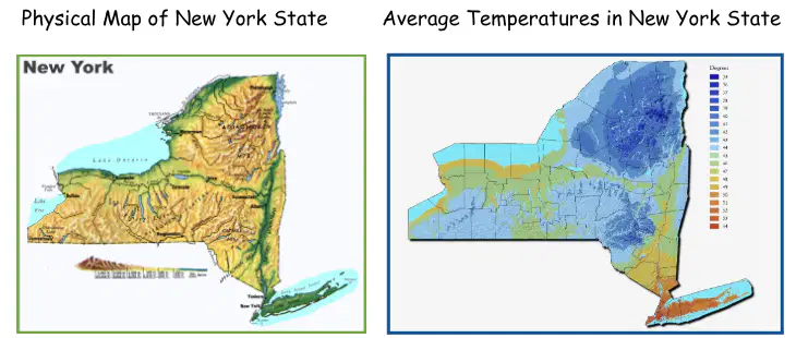
What is one difference between these maps?
They both show temperature
They both show physical features of New York
One shows physical features and the other shows temperature
One shows New York and the other shows Canada
What are two physical features in New York?
Niagara Falls and the Hudson River
The Catskill Mountains and the Grand Canyon
Lake Eerie and the London Bridge
Canada and the Adirondack Mountains
How do the physical features in New York impact how people live, work, and play in these areas?
People who live in the mountains can spend time at the beach.
People who live near rivers can fish for food and drink the fresh water.
People who live in forests can swim for fun.
People who live near the beach can ice skate.
What type of physical feature is located in the areas where the coldest temperatures are found?
Water falls are in the coldest areas
Lakes are in the coldest areas
Mountains are in the coldest areas
Rivers are in the coldest areas
Which is true about New York State maps?
The colder temperatures are where the beaches are.
The flatter land is warmer than the mountainous regions
The warmer temperatures are near the Great Lakes
The higher the mountain, the warmer the temperature.
Which Native American group mostly inhabited New York State?
The Mayans
The Haudenosaunee (Iroquois)
The Aztecs
The Incas
How did Native American groups like the Haudenosaunee interact with
the environment?
They ignored the environment
They only used the environment for fun activities.
They used the environment to survive and meet their basic
needs.
They destroyed the environment
Which language did the Algonquian-speaking groups use in New York
State?
Spanish
French
Algonquian
English
What is an example of how Native American groups interacted with
the environment in New York State?
Building dams to stop rivers
Planting crops and using forests for shelter
Polluting rivers and lakes
Ignoring the wildlife
Which of the following statements is true?
Many people chose to settle in New York because it is mainly
water.
Many people could not settle in New York because mountain
ranges made it difficult.
Many people settled in New York because it has many
different landforms that were useful.
The landforms in New York did not help people decide to
settle here.
What did the Native American groups mostly use forests for in New
York State?
To build skyscrapers
To create artwork
To hunt animals and make shelters
To grow crops only
Which of these is an example of a traditional activity of Native
American groups in New York State?
Using computers
Playing video games
Making pottery and crafts
None of the above
Who were the leaders of the Algonquian (Munsee) clans?
manitous
sachem
wampum
powwow
Who were the leaders of the Haudenosaunee (Iroquois) clans?
spirit dreams
the shaman
the chief
the mom's

