
 Worksheets
Oceanography Midterm Review - Introduction to Oceanography
Total questions: 161
Worksheet time: 3hrs 38mins
What is the scientific study of the oceans, their phenomena, and all their associated life forms called?
Oceanography
Meteorology
Geology
Astronomy
What term describes the interconnected system of all Earth's oceanic waters?
World Ocean
Continental Shelf
Great Barrier Reef
Hydrosphere
Which of the following is NOT a sub-discipline of oceanography?
Geological Oceanography
Chemical Oceanography
Physical Oceanography
Astronomical Oceanography
Match the sub-discipline of oceanography with its correct description:
Geological Oceanography
Study of the seafloor structure, plate tectonics, and sediments.
Chemical Oceanography
Study of the composition of seawater, cycles, and pollution.
Physical Oceanography
Study of waves, tides, currents, and ocean-atmosphere interaction (climate).
Biological Oceanography
Study of marine life, ecosystems, and human impact on biological resources.
Approximately what percentage of the Earth's surface is covered by the ocean?
Approximately 70%
Approximately 50%
Approximately 30%
Approximately 90%
The ocean holds what percentage of the Earth's surface water?
97%
50%
75%
85%
The ocean is critical for regulating global climate and is a major resource for food, energy, and transportation.
True
False

Name two major oceans shown on the map.
Pacific Ocean, Atlantic Ocean
Indian Ocean, Arctic Ocean
Southern Ocean, Indian Ocean
Arctic Ocean, Southern Ocean
The four main branches of oceanography and an example of what each studies are: Biological (marine life), Chemical (seawater composition), Geological (seafloor structure), and Physical (ocean currents).
Biological (marine life), Chemical (seawater composition), Geological (seafloor structure), and Physical (ocean currents)
Meteorological (weather patterns), Astronomical (stars), Volcanological (volcanoes), and Hydrological (rivers)
Botanical (plants), Zoological (animals), Mineralogical (minerals), and Atmospheric (air)
Ecological (ecosystems), Paleontological (fossils), Geographical (landforms), and Climatological (climate)
The importance of the oceans is that they:
regulate the Earth's climate and support marine life
are only important for recreational activities
have no impact on weather patterns
are not connected to the water cycle
The primary contribution of Matthew Fontaine Maury to oceanography was:
mapping ocean currents and winds
discovering the Gulf Stream
inventing the submarine
developing the theory of plate tectonics
The invention of the chronometer was significant for ocean exploration because it allowed sailors to:
Accurately determine longitude at sea
Predict weather patterns
Communicate with other ships
Measure ocean depth
The long-term legacy of the Challenger Expedition was:
the foundation of modern oceanography
the discovery of the Pacific Ocean
the invention of the steam engine
the first manned mission to the Moon
Cartographer: ________
A person who makes maps.
A person who studies stars.
A person who writes books.
A person who builds bridges.
Chronometer: ________
A timepiece accurate enough to determine longitude at sea (invented by John Harrison).
A device used to measure atmospheric pressure.
A tool for measuring electrical resistance.
A machine for calculating distances traveled by vehicles.
Challenger Expedition: ________
The first major global, comprehensive marine science expedition (1872-1876).
A failed attempt to reach the North Pole by submarine (1901-1904).
The first underwater archaeological excavation in the Mediterranean (1880-1882).
A British naval mission to map the Amazon River (1865-1868).
Bathymetry: ________
The measurement of ocean depths and the charting of the shape or topography of the ocean floor.
The study of weather patterns over the ocean.
The process of measuring salinity in seawater.
The analysis of marine animal populations.
Sonar (Sound Navigation and Ranging): ________
A system that uses sound pulses to measure distance and map the seafloor.
A device that measures air pressure in the atmosphere.
A method for detecting light waves in space.
A tool used to measure temperature in the ocean.
CTD (Conductivity, Temperature, Depth): ________
An instrument package used to measure key physical properties of seawater.
A type of underwater vehicle used for deep-sea exploration.
A satellite used for monitoring ocean currents.
A method for desalinating seawater.
Satellite Altimetry: ________
Technique used to measure sea surface height, which can indirectly reveal seafloor topography.
Method for measuring atmospheric pressure at high altitudes.
Process of mapping the magnetic field of the Earth from space.
Technique for tracking animal migration using satellites.
The method of measuring ocean depth has evolved from early exploration to modern times in which of the following ways?
From using weighted ropes to advanced sonar technology
From using satellites to weighted ropes
From using submarines to hand signals
From using GPS to visual estimation
The CTD instrument measures which of the following parameters, and why are these measurements crucial?
Conductivity, temperature, and depth; these measurements are crucial for understanding oceanographic conditions.
Carbon dioxide, turbidity, and dissolved oxygen; these measurements are crucial for monitoring air quality.
Chlorophyll, salinity, and pH; these measurements are crucial for studying plant growth.
Wind speed, wave height, and rainfall; these measurements are crucial for weather forecasting.
Satellite altimetry can map the seafloor without actually touching it by measuring the height of the sea surface from space. Which of the following best explains how this is possible?
By measuring variations in sea surface height caused by underwater features
By sending divers to the seafloor to take measurements
By using underwater robots to scan the seafloor directly
By collecting water samples from the ocean surface
The Nebular Hypothesis explains the process that led to Earth's formation.
It describes how a cloud of gas and dust collapsed to form the Sun and planets, including Earth.
It states that Earth was formed by the collision of two large asteroids.
It suggests that Earth was created by volcanic eruptions on the Sun.
It claims that Earth was formed from a single giant crystal.
Density stratification is the process that led to Earth's layered structure. Which of the following best defines density stratification and explains its role in forming Earth's layers?
It is the separation of materials based on density, causing denser materials to sink and form Earth's core while lighter materials rise to form the crust and mantle.
It is the process by which Earth's surface erodes over time, creating different landforms.
It is the mixing of all Earth's materials into a uniform composition.
It is the cooling of Earth's surface, resulting in the formation of mountains and valleys.
The primary source of water that created the Earth's first oceans was:
volcanic outgassing
melting polar ice caps
photosynthesis by early plants
erosion of surface rocks
Differentiate between oceanic and continental crust based on density and composition.
Oceanic crust is denser and mainly basaltic, while continental crust is less dense and mainly granitic.
Oceanic crust is less dense and mainly granitic, while continental crust is denser and mainly basaltic.
Both oceanic and continental crust have the same density and composition.
Oceanic crust is denser and mainly granitic, while continental crust is less dense and mainly basaltic.
The difference between the Lithosphere and the Asthenosphere is that:
the Lithosphere is rigid and brittle, while the Asthenosphere is semi-fluid and can flow
the Lithosphere is hotter than the Asthenosphere
the Asthenosphere is above the Lithosphere
the Lithosphere is made of liquid magma, while the Asthenosphere is solid rock
The Inner Core is solid, even though it is hotter than the liquid Outer Core, because:
the pressure is so high that it keeps the core solid
it is made of different materials than the Outer Core
it cools down faster than the Outer Core
the Inner Core is older than the Outer Core
Crust: _________.
The thin, outermost layer (Oceanic and Continental).
The thick, innermost layer of the Earth.
A layer made entirely of molten iron.
The gaseous layer surrounding the Earth.
Mantle: _________.
The thick, hot, solid layer between the crust and the core.
The thin, outermost layer of the Earth.
The Earth's liquid outer core.
The Earth's atmosphere.
Core: _________
The innermost, densest part of the Earth (Outer is liquid, Inner is solid).
The outermost, thinnest layer of the Earth.
A layer made mostly of silicate rocks, located above the core.
A gaseous layer surrounding the Earth.
Lithosphere: _________.
The rigid outer layer, composed of the crust and the uppermost mantle; broken into tectonic plates.
A layer of molten rock beneath the Earth's surface.
The innermost layer of the Earth, composed mainly of iron and nickel.
A gaseous layer surrounding the Earth.
Asthenosphere: _________
The plastic (flowing), hot, weaker layer beneath the lithosphere.
The rigid outermost shell of the Earth.
A solid, cool, and brittle layer above the mantle.
The innermost metallic core of the Earth.
Continental Drift: _________.
The hypothesis (proposed by Alfred Wegener) that continents move over time.
The process by which mountains are formed from volcanic eruptions.
The theory that continents have always remained in the same position.
The idea that ocean currents shape the continents.
Seafloor Spreading: _________.
The theory (proposed by Harry Hess) that new oceanic crust is created at mid-ocean ridges and moves outward.
The process by which continents drift apart due to wind erosion.
The idea that ocean water evaporates to form new land masses.
The movement of tectonic plates caused by lunar gravitational pull.
Subduction: _________.
The process where one tectonic plate descends beneath another.
The process where two plates move away from each other.
The process where mountains are formed by folding.
The process where magma rises to form new crust.
Mid-Ocean Ridge (MOR): _________
A long, underwater mountain range where new crust is formed.
A deep trench where old crust is destroyed.
A flat plain found at the bottom of the ocean.
A volcanic island chain formed by hotspots.
The key piece of evidence that confirmed Harry Hess's theory of seafloor spreading was:
the discovery of symmetrical patterns of magnetic stripes on either side of mid-ocean ridges
the presence of dinosaur fossils on the ocean floor
the measurement of deep ocean trenches only in the Pacific Ocean
the finding of coral reefs at great ocean depths
The geological activity that occurs at a convergent boundary where oceanic crust meets continental crust is:
Subduction of the oceanic plate beneath the continental plate
Formation of mid-ocean ridges
Creation of rift valleys
Divergence of tectonic plates
The major flaw in Alfred Wegener's original theory of Continental Drift was:
He could not explain the mechanism that moved the continents.
He believed the Earth was flat.
He thought continents never moved at all.
He claimed the continents were made of water.
The main difference between an active continental margin and a passive continental margin is:
Active margins are associated with plate boundaries and tectonic activity, while passive margins are not.
Passive margins are found at plate boundaries, while active margins are not.
Active margins have no tectonic activity, while passive margins do.
Passive margins are characterized by frequent earthquakes and volcanoes, while active margins are not.
The three main components of a typical continental margin are:
continental shelf, continental slope, continental rise
continental shelf, abyssal plain, mid-ocean ridge
continental rise, ocean trench, seamount
continental slope, island arc, rift valley
The unique ecosystem that exists around hydrothermal vents is characterized by:
organisms relying on chemosynthesis instead of photosynthesis
abundant sunlight supporting plant life
a dominance of terrestrial animals
ecosystems based on photosynthesis
The principle behind using echo sounding to determine ocean depth is based on which of the following?
Measuring the time taken for sound waves to travel to the ocean floor and back
Observing the color of the water
Counting the number of waves on the surface
Measuring the temperature of the water
Multibeam sonar improves upon older, single-beam methods by:
providing wider and more detailed coverage of the seafloor
using only a single sound pulse at a time
reducing the accuracy of underwater mapping
eliminating the need for any sonar equipment
The purpose of using seismic reflection profiling in oceanography is:
to study the structure of the ocean floor
to measure ocean salinity
to track marine animal migration
to monitor surface wave patterns
Bathymetry: ________ is the measurement of ocean depths (same as Topic 3).
Bathymetry
Topography
Meteorology
Seismology
Multibeam Sonar: ________ is a system of transducers that sends out multiple beams to map a wide area of the seafloor simultaneously.
Multibeam Sonar
Single Beam Echo Sounder
Side Scan Sonar
Sub-bottom Profiler
Terrigenous Sediment: ________ is sediment derived from land (from weathering and erosion).
Terrigenous Sediment
Biogenous Sediment
Hydrogenous Sediment
Cosmogenous Sediment
Biogenous Sediment: ________ is sediment derived from the remains of marine organisms (shells, skeletons).
Biogenous Sediment
Terrigenous Sediment
Hydrogenous Sediment
Cosmogenous Sediment
Hydrogenous Sediment: ________ is sediment precipitated directly from seawater (e.g., manganese nodules).
Hydrogenous Sediment
Terrigenous Sediment
Biogenous Sediment
Cosmogenous Sediment
Cosmogenous Sediment: ________ is sediment derived from outer space (e.g., meteor dust).
Cosmogenous Sediment
Biogenous Sediment
Hydrogenous Sediment
Lithogenous Sediment
Ooze: ________ is deep-sea sediment composed of at least 30% biogenous material.
Ooze
Clay
Sand
Gravel
The four main sources of seafloor sediment are:
Terrigenous, biogenous, hydrogenous, cosmogenous
Igneous, metamorphic, sedimentary, volcanic
Organic, inorganic, chemical, physical
Continental, oceanic, volcanic, glacial
The most abundant type of sediment by volume and its source is:
Terrigenous sediment from land
Biogenous sediment from marine organisms
Hydrogenous sediment from chemical reactions in water
Cosmogenous sediment from space
Calcareous ooze and siliceous ooze differ in composition and typical locations. Which statement correctly describes this difference?
Calcareous ooze is composed of calcium carbonate and is typically found in shallower, warmer ocean regions, while siliceous ooze is composed of silica and is usually found in deeper, colder waters.
Calcareous ooze is composed of silica and is found in deep ocean basins, while siliceous ooze is made of calcium carbonate and found in shallow seas.
Both calcareous and siliceous oozes are composed of organic matter and are found only near hydrothermal vents.
Siliceous ooze is found in shallow, tropical waters, while calcareous ooze is found in polar regions.
The longshore current plays which role in beach formation and erosion?
It transports sand along the coast, shaping beaches and causing erosion.
It prevents any movement of sand along the shore.
It only builds up beaches without causing erosion.
It has no effect on the shape of beaches.
The primary function of a barrier island is to:
Protect the mainland from storms and erosion, but they are dangerous for permanent construction due to their shifting nature.
Provide a stable foundation for buildings and infrastructure.
Serve as a permanent landform ideal for urban development.
Act as a freshwater source for nearby cities.
The unintended consequences that often result from building groins or seawalls to combat beach erosion include:
Increased erosion in adjacent areas
Permanent prevention of all erosion
Creation of new beaches everywhere
No impact on surrounding environments
Define Longshore Current.
A water movement parallel to the coast, generated by waves approaching the shore at an angle.
A deep ocean current caused by temperature differences.
A tidal wave moving perpendicular to the shoreline.
A current formed by river discharge into the sea.
Define Longshore Transport (Drift).
The movement of sand and sediment down the beach by the longshore current.
The process of wind eroding coastal cliffs.
The deposition of sediment by rivers into the ocean.
The upward movement of water due to tides.
What is a Barrier Island?
Long, narrow, low-lying islands parallel to the coast, separated from the mainland by a lagoon.
A mountain range found inland, far from the coast.
A type of coral reef found only in tropical waters.
A deep underwater trench located at the edge of the continental shelf.

A is the (a) Ocean.
C is the (a) Ocean.

Which Ocean on the image is the largest and deepest?
A
B
C
D
E
The average salinity of ocean water is
20 ppt
5 ppm
5 %
35 ppt
Which of the world's ocean is the deepest?
Arctic
Atlantic
Indian
Pacific
What does SONAR equipment measure?
the density of the ocean's water
the depth of the ocean's floor
the noise produced by bottom-dwelling creatures
the shape of the ocean's surface
Scientists use satellites to measure the
ocean floor depth
size of underwater features
sea- surface height
salinity
Which of the following form at mid-ocean ridges?
island arcs
sea stacks
guyots
new ocean floor
Abyssal plains are very flat features that form when
volcanoes spread lava on the ocean floor
turbidity currents deposit sediments on the ocean floor
ocean waters flood plains on land
plates diverge on the ocean floor causing sea-floor spreading
Which is a characteristic of life at the abyssal zone?
seaweeds attached to the seafloor
no photosynthesis occurs
no availability of food
warm-water organisms are plentiful
The (a) is the gently sloping submerged surface extending from the shoreline.
How do scientists use sonar to study Earth’s oceans?
to map ocean currents
to map the ocean floor
to measure water density
to measure underwater earthquakes

Different ions are found in ocean water. Vasily’s teacher gives him this table, which lists the six most common ions found in ocean water. Based on the information in the table, the ions of which of the following salts is most commonly found in ocean water?
sodium sulfate
sodium chloride
calcium chloride
magnesium sulfate
A scientist is studying a region of the ocean floor. She discovers a long, deep canyon that runs parallel to the coastline of a nearby continent. What can she infer from this discovery?
The oceanic plate is sliding past the continental plate.
The oceanic plate is sliding under the continental plate.
The continental plate is sliding under the oceanic plate.
The continental plate is pulling away from the oceanic plate.
Which of the following Ocean basins is closest to Georgia?
Pacific
Atlantic
Indian
Arctic
The name of the first scientific expedition to explore the world's oceans and sea floor.
Deep Sea Challenge
The Challenger Expedition
HMS Beagle
When did modern oceanography really begin to "take off"?
World War II
Civil War
Revolutionary War
Vietnam War
Beginning 25,000 years ago, the Polynesians began to colonize the islands of the _____________________.
Mediterranean Sea
Indian Ocean
South and Western Pacific Ocean
Atlantic Ocean
Captain James Cook prevented his sailors from getting Scurvy by making them eat ____________________________.
Chicken
Bananas
Pickled Cabbage
Potatoes
The deepest part of the ocean is the ______________________.
Peru Chile Trench
Puerto Rican Trench
Marianas Trench
When did modern oceanography begin as a field of science?
In the early 18th century
In the late 19th century
In the mid-20th century
In the early 21st century
Match the following civilizations/historical figures to their marine science contributions
Phoenicians
Started sailing the Med.
Romans
Developed the basic water cycle.
Vikings
Got to North America first.
Magellan
Attempted to circumnavigate the earth.
Capitan Cooke
Found a cure for scurvy.
The Polynesians were known for traveling across open oceans in what type of boats?
Long oar ships
Large Trifold sailing ships
Dug out canoe ships
Catamarans
First culture to use mathematical equations when determining distances and relational travelling
Polynesians
Europeans
Phoneceans
Greeks
One main difference between ROV's and AUV's are that ROV's are
steered by a person continuously.
not tethered.
able to get continuous data.
Name of the famous marine researcher that design tested underwater living chambers in the 1970's as well as who we watched a movie on
Lamont
Charles Darwin
Frans Ferdinand
Jacques Cousteau
How does a chronometer help us understand the oceans?
Keeping accurate time helps us know latitude
Keeping accurate time lets us know when dinner is
Keeping accurate time lets us know longitude
Keeping accurate time let us know when we are on the equator
What does SONAR stand for?
Sound, Navigation, and Ranging
Sound, Nautical, and Radar
Signal, Navigation, and Radar
Signal, Nautical, and Ranging
What technology supported the drift theory by mapping ocean ridges?
Radar
GPS
Echo sounders
Satellites

Who is considered the father of oceanography and wrote the first textbook on Oceanography "The Physical Geography of the Sea"?
Ben Franklin
Jack Trieste
Matthew Maury
Charles Darwin

A map of the seafloor (or the bottom of any body of water) is called a...
Contour map
Mercator map
Bathymetric Map
topographic map
What is one significant challenge in mapping the ocean floor?
Limited technology
The vastness of the ocean
Difficulties in accessing deep-sea environments
All of the above
What feature is characterized by underwater mountains with a peak or flat top?
Mid-ocean Ridge
Seamount
Abyssal Plain
Continental Shelf
Which type of sediment includes materials from outer space?
Terrigenous
Biogenous
Hydrogenous
Cosmogenous
What type of seafloor feature is a steep-sided underwater valley?
a. Submarine Canyon
b. Seamount
c. Continental Rise
d. Mid-ocean Ridge
What is the primary source of biogenous sediment?
a. Volcanic ash
b. Eroded land particles
c. Marine organism shells
d. Chemical precipitates
How do scientists map the ocean floor using satellites?
a. By measuring the temperature of the water
b. By observing the surface of the water
c. By tracking sea level changes
d. By analyzing gravity variations
Which seafloor feature is characterized by a gently sloping land area along the edges of continents?
a. Continental Shelf
b. Abyssal Plain
c. Mid-ocean Ridge
d. Trench
Which type of beaches are characterized by large rocks and boulders?
sandy beaches
rocky beaches
gravel beaches
pebble beaches
What type of sand is commonly found on sandy beaches?
limestone sand
silica sand
quartz sand
volcanic sand
What is the process by which sediment is transported along the shoreline called?
tidal wave
coastal erosion
beach nourishment
longshore drift
What type of beaches are formed by volcanic activity?
white sand beaches
black sand beaches
pink sand beaches
pebble beaches

Which type of beaches are more likely to have pebbles and cobbles?
Beaches that are closer to their source material.
Beaches that are farther from their source material.

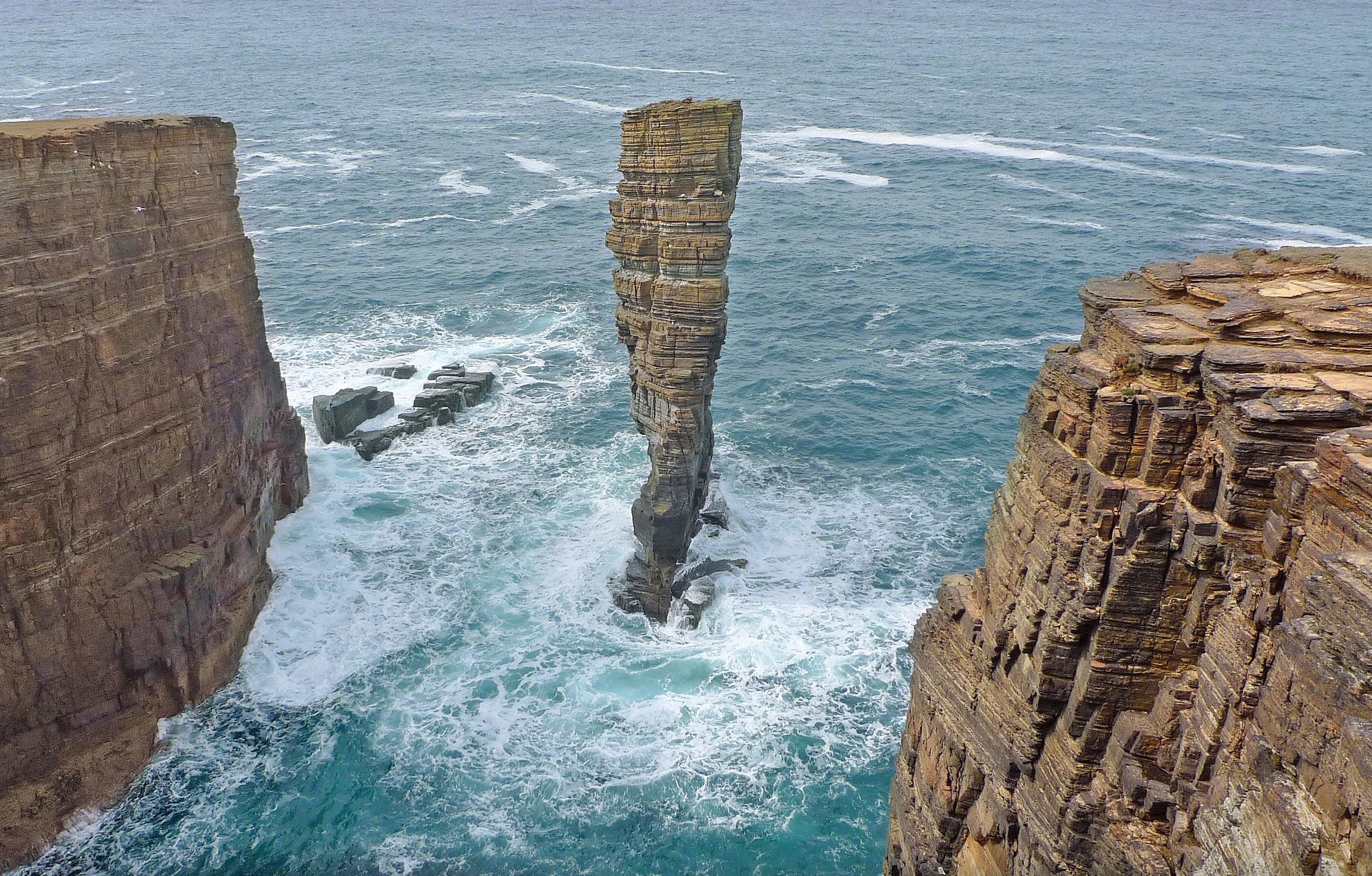
Identify the landform type.
Sea Stack
Sea Stump
Arch
Bay

What coastal defence can be seen in this image?
Groin
Sea wall
Gabions
Revetments

These structures are usually built around an inlet to prevent sand from filling the waterway.
breakwater
groin
jetties
seawall
Which statement best describes beaches?
Beaches change little over time as wind patterns stay the same.
Beaches change little over time as waves follow the same patterns year after year.
Beaches are always changing due to factors such as waves adding and eroding sand.
Beaches change over time as waves move further up the shore.

What is the stretch of sand shown in this photo called?
a headland
a sand bar
a tombolo
a sand spit
What creates longshore current?
Which way the rip current is moving
The direction that the majority of boats are moving in
The angle at which the swash washes onto the beach
The depth in the surf zone
What creates sand bars, sand spits, and tombolos?
slack currents
rip currents
ocean gyres
longshore currents

What is the origin of this sediment? These are tiny shells called "tests."
Lithogenous
Biogenous
Hydrogenous
Cosmogenous
Manganese nodules are considered to be:
hydrogenous sediments.
lithogenous sediments.
biogenous sediments.
cosmogenous sediment.
if more than 30% of an area's sediment is made up of biogenous particles, it is called a(n)
ooze
slush
mud
silt
Small, solid pieces of materials from rocks or living things
sediment
clastic rock
organic rock
deposition
Match the following
Lithogenous
Derived from the breakdown of rocks
Biogenous
Derived from the remains of living organisms
Cosmogenous
Derived from outer space
Hydrogenous
Derived from water chemistry
Sediments made from microscopic shells that settle to the bottom when the organisms that produced them die are called
biogenous sediments.
hydrogenous sediments.
manganese nodules.
terrigenous sediments.
Beach deposits are an example of
hydrogenous sediment.
cosmogenous sediment.
biogenous sediment.
lithogenous sediment.
Which of the following is a significant source of terrigenous sediments found in marine environments?
A) Volcanic eruptions
B) River discharge
C) Coral reef erosion
D) Deep-sea hydrothermal vents
What is the name for the structures that protect mainland beaches from erosion by waves and storms?
Rift Zones
Inlets
Barrier Islands
Rip tides
A landform that is always found along the shoreline of a body of water. It is usually made up of loose particles, such as sand and rock. What is this landform?
A fault line
Beach
An ocean ridge
A canyon
A severe storm would be most likely to damage a coastal area by causing________?
Erosion
Earthquakes
Pollution
Volcanoes

Which feature is located between the offshore and the foreshore?
Beach Terrace
Surf Zone
Beach Face
Trough

What is the term for the area where waves break before reaching the shore?
Beach Face
Surf Zone
Beach Terrace
Offshore
Which region of a beach is typically affected by both high and low tides?
Dunes
Foreshore
Backshore
Offshore
Which region of a beach is typically the most stable and least affected by daily tides?
Offshore
Foreshore
Backshore
Dunes
Which feature is formed by the cutting action of storm waves?
Sand Dune
Winter Berm
Summer Berm
Scarp

Where are you walking when you are wading in the ocean?
Ocean Trench
Abyssal Plain
Continental Slope
Continental Shelf
What technology uses sound waves to measure ocean depth?
a. Radar
b. Sonar
c. Lidar
d. Satellite imaging
What is the primary source of biogenous sediment?
a. Volcanic ash
b. Eroded land particles
c. Marine organism shells
d. Chemical precipitates
A map of the seafloor (or the bottom of any body of water) is called a...
Contour map
Mercator map
Bathymetric Map
topographic map
What answer choice best describes a unit of depth in the ocean that is commonly used in countries using the English system of units?
bathymetry
sounding
fathom
echo sounder
What answer choice best describes a device that transmits sound from a ship to the ocean floor?
bathymetry
sounding
fathom
echo sounder
What is the difference between a guyot and a seamount?
Guyots are rounded, seamounts are not.
Seamounts are rounded, guyots are not.
Seamounts have been weathered by wave and becomes a guyot, a cone shaped volcano.
Seamounts are cone shaped volcanoes, and biologically, that would scientifically confirm that there is no difference.
What answer choice best describes a measured depth of water beneath a ship? (From Chapter 3.1)
bathymetry
sounding
fathom
echo sounder
ping
When was the echo sounder (sonar) invented?
1920s
1800s
2000s
1950s
What marks the seaward edge of the continental shelf?
Continental slope
Abyssal plains
Submarine canyons
Continental rise
During a marine biology expedition, researchers discovered a type of sediment that comprises shells and skeletons of marine organisms. What is this type of sediment called?
Biogenous sediment
Terrigenous sediment
Volcanic sediment
Hydrogenous sediment
When a wave crashes against the summit of an underwater mountain, it causes the peak to flatten. What seafloor feature is this?
guyot
atoll
island
seamount

Why does the “zero” depth line start at the top of the scale? (*select all that apply)
because you are measuring meters below the sea surface
It means the graph starts at a shore or a coast and begins at sea level.
distance is measured in kilometers
graphs always start at 0
What is the deepest depth shown on the graph?
-10,000 m
-10,000 km
300 km
350 km
What is the deepest depth shown on the graph?
-10,000 m
-10,000 km
300 km
350 km
what seafloor feature might this graph represent?
deepsea trench
rocky coastline
open-ocean
underwater volcano

What does SCUBA stands for?
Self Controlled Underwater Breaking Apparatus
Self Controlled Underwater Breathing Apparatus
Self Contained Underwater Breaking Apparatus
Self Contained Underwater Breathing Apparatus

What does AUV stand for?
Autonomous Underwater Vehicle
Autonomous Above-Water Vehicle
Autoparts Underwater Vehicle
Automatic Underwater Vessicle

