
 Worksheets
Reading Maps
Total questions: 37
Worksheet time: 2hrs 35mins





The distance between contour lines is called...
Contour interval
Contour line
Colors
Mountains

If the lines are far apart, it means it is a slow or ________________ rise/drop
Gradual
Steep

If the lines are close together on the map, it means that the rise/drop is ________________
Steep
Gradual

Determine the interval by counting from the smallest to the biggest number. Look for a pattern, or the number that each line ‘jumps’ by between the numbers. Each line should have a number it represents.
The interval is 10 because each line counts up by 10.
The interval is 60 because that is the biggest number.
The interval is M

Which one is the steepest?
2
1
4
What can you find on a topographic map
height of a mountain & the gradient/slope
people
animals

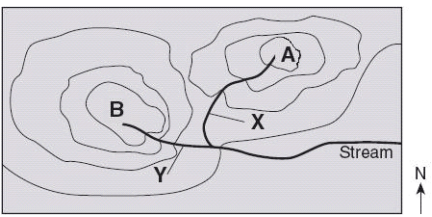
Which trail would be a more difficult hike, A or B?
A
B

What is the elevation of point A?
50 m
75 m
100 m

What is the elevation of point B?
150 m
250 m
350 m
Where do most earthquakes tend to occur?
The boundaries between continents and oceans.
In the center of tectonic plates.
Underneath large mountain ranges.
In the middle of oceans.
Mountain range
A series of connected mountains
A single isolated mountain
A flat area of land
A body of water surrounded by land
Hot Spot
Places where hot magma rises through the Earth's surface
Areas with frequent earthquakes
Regions with high volcanic activity
Locations of major tectonic plate boundaries

Which of the following paths is steeper?
Path A
Path B

Which circle best represents the steepest slope?
Circle A
Circle B

Which of the following paths has a gentler slope?
Path A
Path B

Which circle best represents the gentlest slope?
Circle A
Circle B
What is the highest point on a topographic map called?
Base
Summit or peak
Valley
Plateau

What do contour lines on a topographic map tell us?
Contour lines on a topographic map represent temperature.
Contour lines on a topographic map represent elevation.
Contour lines on a topographic map represent the number of people who live in an area.
Contour lines on a topographic map represent country boundaries.

Imagine Jackson, Noah, and Avery are on a hiking adventure. They come across a map with contour lines close together. What does this mean for their journey?
It means they are about to encounter a flat slope.
It doesn't mean anything.
It means they are about to encounter a steep slope.
It means they will be walking on no slope.

What does it mean when contour lines form closed loops on a topographic map?
There is a river or a stream in the area.
There is a plateau or a mesa in the area.
There is a fault line or a tectonic boundary in the area.
There is a hill in the area.

A satellite image and a topographic map of the island of Hawaii are shown. A farmer wants to buy a large, flat piece of land on the island to plant crops. What location best fits this description?
Y
W
X
Z

Which blue spot on the topographical map below could be on a mountain peak?
A
B
C
D

. Which blue spot on the topographical map is at the lowest elevation?
A
B
C
D

