
 Worksheets
Ocean Currents and Tides Test Review
Total questions: 30
Worksheet time: 17mins
What role do ocean gyres play in Earth's climate?
They create hurricanes and tropical storms
They transfer heat from the tropics to the polar regions
They prevent oceans from freezing
They regulate rainfall patterns in desert regions
What causes surface currents in the ocean?
Temperature and salinity differences
Wind pushing water across the surface
Earth's rotation
Gravitational pull of the moon
What is the main cause of tides on Earth?
Ocean currents
Wind patterns
Gravitational pull of the moon and sun
Earth's rotation alone
Which of the following best defines an ocean gyre?
A deep ocean trench
A system of rotating ocean currents around a central point
An area where two ocean currents meet
The upward movement of cold water from the deep ocean
Which of the following is a characteristic of cold surface currents?
Heavy rainfall on nearby coasts
Low evaporation rates
High humidity
Decreased cloud cover
During El Niño conditions in the Pacific Ocean:
Trade winds strengthen
Upwelling along South America strengthens
Eastern Pacific waters become warmer
Food webs thrive due to increased nutrients
The Coriolis Effect causes ocean currents to:
Speed up near the equator
Move in straight lines
Spiral clockwise in the Northern Hemisphere
Spiral counterclockwise in the Northern Hemisphere
Tidal patterns that have one high and one low tide each day are called:
Semidiurnal tides
Diurnal tides
Mixed tides
Spring tides
The Global Ocean Conveyor Belt is also known as:
The Gulf Stream
Thermohaline circulation
El Niño Southern Oscillation
The Humboldt Current
La Niña conditions in the Pacific Ocean are characterized by:
Weaker than normal trade winds
Stronger than normal trade winds
Warmer waters in the eastern Pacific
Decreased upwelling off South America
The vertical difference in water level between high and low tide is called:
Tidal range
Tidal cycle
Tidal circulation
Tidal bulge
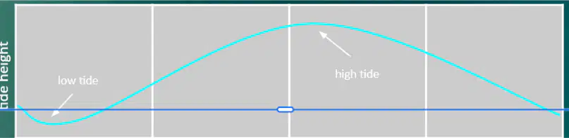
What tidal pattern is shown by the graph below?
Diurnal Tides
Semidiurnal Tides
Mixed Tides
Rip tides
Which tide has the smallest tidal range of the month?
Spring tide
Neap tide
Flood tide
Ebb tide
What would happen to many estuaries without daily tidal circulation?
They would become more biologically diverse
They would become hypoxic (low oxygen) or hypersaline (very salty)
They would dry up completely
They would become deeper
The inflow of tide into bays and estuaries is called:
Ebb tide
Flood tide
Slack tide
Spring tide
When the moon and sun are at a 90° angle to one another relative to Earth, what type of tide occurs?
Spring tide
Neap tide
Diurnal tide
Semidiurnal tide
Which of the following is NOT a factor that influences tidal patterns?
Shape and size of the coastline
Ocean basin size
Ocean currents
Gravitational pull of the sun and moon
What causes vertical currents in the ocean?
Wind patterns
Temperature and salinity differences
Earth's rotation
Gravitational pull of the moon
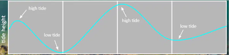
What tidal pattern is shown by the graph below?
Diurnal Tides
Semidiurnal Tides
Mixed Tides
Rip tides
Downwelling occurs when:
Surface water rises due to wind patterns
Warm water spreads across the ocean surface
Dense, salty water sinks
Trade winds push water toward the shore
The period during which there is no tidal movement is called:
Ebb tide
Flood tide
Slack tide
Spring tide
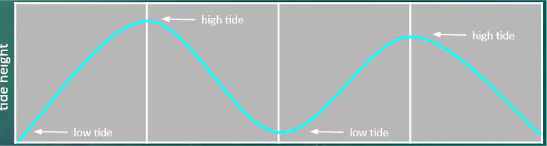
What tidal pattern is shown by the graph below?
Diurnal Tides
Semidiurnal Tides
Mixed Tides
Rip Tides
Which statement best describes the upwelling off the western coast of South America during El Niño, La Niña, and normal conditions?
El Niño decreases upwelling, La Niña increases it, and normal conditions maintain moderate upwelling.
El Niño increases upwelling, La Niña decreases it, and normal conditions maintain moderate upwelling.
El Niño and La Niña both increase upwelling, while normal conditions decrease it.
El Niño and La Niña both decrease upwelling, while normal conditions increase it.

A flat area that has dark colored, sticky, smelly mud is a:
intertidal zone
beach
tidal flat
jetty
The number of organisms increase as the ocean depth decreases.
True
False
Which layer of the ocean would have the highest water pressure
As you swim deeper towards the ocean floor, ______ and ______ increase.
As you swim deeper towards the ocean floor, _____ and ______decrease.
The _____________________ is the gently sloping submerged surface extending from the shoreline.
continental margin
continental slope
abyssal plain
Which ecosystem is this? : These ecosystems are the areas of shorelines that are left uncovered during low tide but which are underwater during high tide; they are usually rocky, but in tropical areas they may be sandy; organisms that live here need to adapt to the waves, the sun, and both marine and land predators
Deep sea
Open ocean
Intertidal zone
Coral reefs

