
 Worksheets
REVIEW: 25-26-Western Hemisphere Geography
Total questions: 42
Worksheet time: 24mins
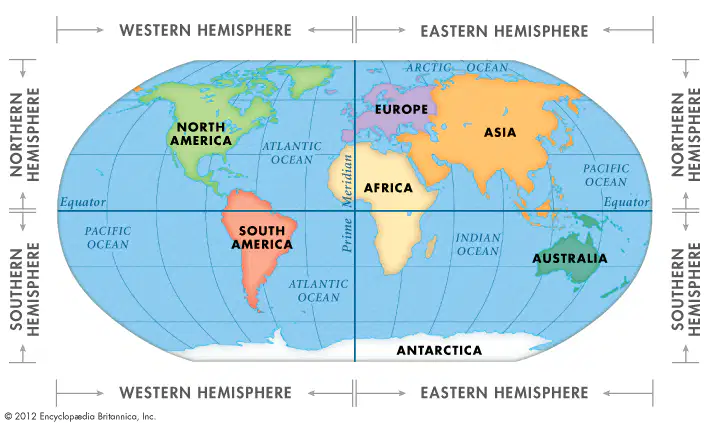
Study the map: In which hemisphere(s) does North America lie?
(Check ALL that apply.)
Northern
Southern
Western
Eastern
Study the map: In which hemisphere(s) does South America lie?
(Check ALL that apply.)
Northern
Southern
Western
Eastern

Study the map: Which landform stretches across western North America from Canada to New Mexico?
Appalachian Mountains
Rocky Mountains
Great Plains
Sierra Madre Oriental

Study the map : Which major body of water lies between the Great Plains and the Appalachian Mountains?
The Hudson Bay
The Mississippi River
The Rio Grande
The Gulf of Mexico
Study the map : Which major body of water lies between the Canadian and U.S border?
The Hudson Bay
The Great Lakes
Lake Winnipeg
The Hudson River

Study the map: What landform lies between the Sierra Madre Occidental and the Sierra Madre Oriental Mountain ranges in Mexico?
Yucatan Peninsula
Great Plains
Mexican Plateau
Sonoran Desert

Study the map: According to the map, which type of vegetation covers most of Canada?
Forests
Tundra
Grasslands
Deserts
Study the map: How might vegetation zones affect the jobs or lifestyles of people who live in the grassland regions?
People in grassland regions often work in farming and ranching, shaping
People in grassland regions are mainly involved in fishing and marine activities.
Residents of grassland regions focus on tourism and hospitality services.
People in grassland regions primarily work in technology and finance.
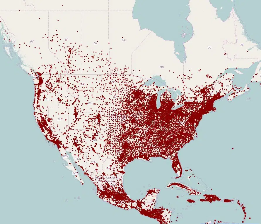
Study this population density map: What generalizations can be made about where people live in the United States?
People live evenly distributed across the entire United States.
The western United States has the highest population density.
Most people reside in rural areas throughout the country.
People live mainly in the eastern United States
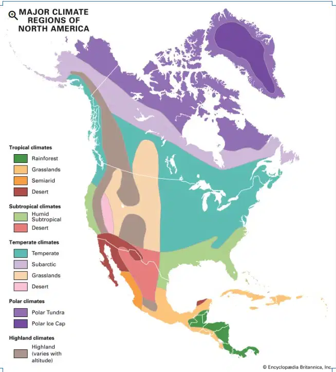
Study the map:
Compare the climates of northern Canada and southern Mexico.
Which statement best explains why their climates are different?
Geography doesn’t affect the climate in different places.
Geography affects climate by changing temperature and rainfall based on how far a place is from the Equator.
The temperature and rainfall are the same in both places because of geography.
Geography only affects the weather in cities, not in the countryside.
Study the map:
What generalization can be made about the climate of North America?
North America has no significant climate variations.
North America experiences only arid and polar climates.
North America has a uniform climate with only temperate regions.
North America has a diverse climate that includes tropical, temperate, arid, and polar regions.
Why do most major North American cities exist near coasts or rivers?
People preferred to avoid living near farmland
To avoid natural disasters and extreme weather
Because rivers are prettier areas to live
Most major North American cities exist near coasts or rivers for trade, transportation, and resource access.
Which Central American landform connects North and South America?
Andes Mountains
Panama Canal
Isthmus of Panama
Caribbean Sea
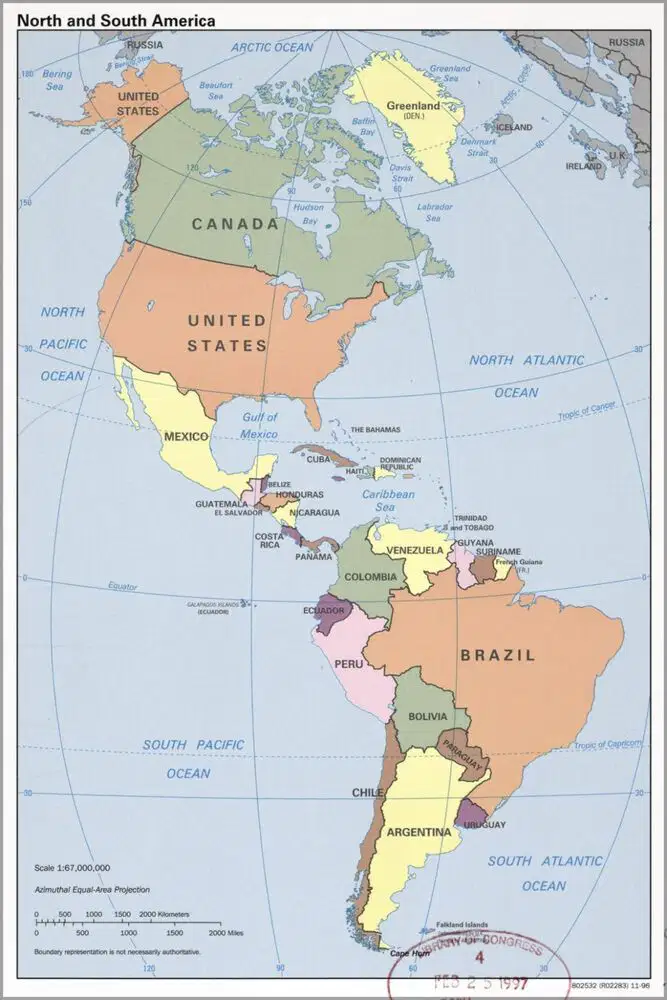
Study the map:
Which two bodies of water border Central America?
Caribbean Sea, Pacific Ocean
Mediterranean Sea, Bering Sea
Indian Ocean, Red Sea
Atlantic Ocean, Gulf of Mexico
Central America has fertile volcanic soil and a warm climate. As a result, what kind of work is most common there?
Mining and extraction
Agriculture and farming
Tourism and hospitality
Manufacturing and industry
Central America lies between the Tropic of Cancer and the Tropic of Capricorn.
What does this mean for the climate in this region?
The region is usually warm and humid, with lots of sunlight and frequent rain.
The region is mostly cold and dry all year.
The region often has snow and freezing temperatures.
The region is covered in desert with almost no rainfall.
What are the names of the 4 largest Caribbean islands?
Trinidad, Puerto Rico, Barbados, St. Lucia
Barbados, Hispaniola, Trinidad, Aruba
Saint Lucia, Cuba, Jamaica, Barbados
Cuba, Hispaniola, Jamaica, Puerto Rico
What is the name for the 2 groups of Caribbean Islands that include most of the islands in this region?
Bahamas and Bermuda
Greater and Lesser Islands
Greater Antilles and Lesser Antilles
Caribbean Sea and Atlantic Ocean
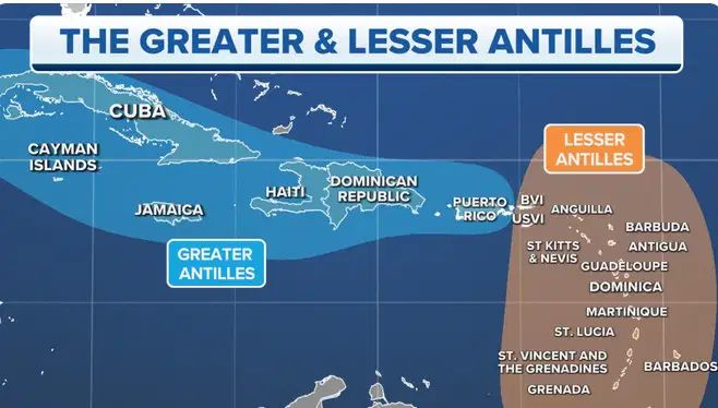
Study the map:
Which Islands are NOT part of the Greater of Lesser Antilles?
Cayman Islands
St. Lucia
Puerto Rico
Bahamas,
The Caribbean Islands were formed in two different ways. which statement best describes how they were made?
Some Caribbean Islands were formed by volcanoes, and others were built up by coral made from tiny sea animals.
The Caribbean Islands were created by glaciers melting and moving.
The Caribbean Islands were formed when wind and rain wore down mountains
The Caribbean Islands were formed when the ocean floor suddenly rose to the surface.
Because the Great Lakes are large bodies of water, which types of jobs or industries are most common near them?
Gold mining and desert farming
Ocean surfing and coral diving
Shipping, boat building, and trade
Cattle ranching and oil drilling
How does the Panama Canal help both trade and travel around the world.
The Panama Canal increases shipping times and costs.
It lets ships take a shorter route between oceans
It keeps ocean animals from swimming across
It connects North America to Europe
Much of Central America has a warm, tropical climate with fertile soil.
What kinds of crops might people grow there?
Corn, bananas, and coffee
Apples and pumpkins
Wheat and potatoes
Pine trees and cactus plants
Central America has hurricanes, earthquakes, and volcanoes. How might these affect where people live and build homes?
People build more homes made of wood and live close to the ocean
People only live deep underground to stay cool
People choose to live on top of volcanoes for better views
People may build strong houses and avoid dangerous areas

Study the map: What is the largest lake in Central America?
Lake Atitlán
Lake Nicaragua
Lake Managua
Lake Izabal
Study the map:
Which part of Central America has the highest elevation (mountains)?
Along the Caribbean Sea near Belize
Along the Pacific coast of Guatemala and Honduras
Around Lake Nicaragua and the lowlands
In the country of Panama near the canal

Study the maps of South America:
Which country contains most of the Amazon Rainforest?
Brazil
Colombia
Peru
Venezuela
Which South American country do the Andes Mountains NOT pass through
Paraguay
Argentina
Peru
Chile
The Andes Mountains form a tall barrier between the coast and the inside of South America.
How might this affect travel and communication between different areas?
Travel is slower and harder because of steep mountains.
Some areas are more isolated and harder to reach.
People must build tunnels, roads, or bridges to cross the mountains
The Andes make it easy for everyone to travel quickly.
Which of the following are notable landforms in South America?
(Check ALL that apply.)
Andes Mountains
Amazon Rainforest
Sahara Desert
Atacama Desert
Which are notable bodies of water in South America?
(Check ALL that apply.)
Amazon River
Lake Titicaca
Rio Grande River
Orinoco River
Which of the following are notable landforms in North America?
(Check ALL that apply.)
Rocky Mountains
Appalachian Mountains
Great Plains
Andes Mountains
Which are notable bodies of water in North America?
(Check ALL that apply.)
Great Lakes
Mississippi River
Gulf of Mexico
Missouri RIver
Hudson Bay
Which are notable landforms in Central America?
(Check ALL that apply.)
Mountain ranges and volcanoes
Coastal plains
Vast deserts
tropical rainforests
Which are notable bodies of water in Central America?
(Check ALL that apply.)
Caribbean Sea
Pacific Ocean
Panama Canal
Hudson Bay
Which are notable landforms found in the Caribbean?
(Check ALL that apply.)
Islands made from coral reefs
Volcanic islands
Vast desert areas
Low, sandy beaches
Which are notable bodies of water in the Caribbean region?
(Check ALL that apply.)
Caribbean Sea
Atlantic Ocean
Gulf of Mexico
Pacific Ocean
What generalization can be made about the geography of the western hemisphere?
The western hemisphere is mainly desert with little variation.
The western hemisphere has a steady climate with no major geographical differences.
The western hemisphere is entirely covered by forests and mountains.
The western hemisphere is diverse in geography, featuring a variety of climates and landscapes across North and South America.
What generalization can be made about the geography of the Caribbean?
The Caribbean is mostly made up of islands surrounded by warm ocean water.
The Caribbean is a cold region covered in ice and snow.
The Caribbean is made up of flat deserts with little rainfall.
The Caribbean has tall mountains and no coastlines.
What generalization can be made about the geography of Central America?
Central America is a wide desert with very little rainfall.
Central America is flat and covered with ice most of the year.
Central America has mountains, rainforests, and narrow land between two oceans.
Central America is made up only of islands in the ocean.
What generalization can be made about the geography of South America?
The geography of South America is flat and looks the same everywhere.
The geography of South America is diverse and varies throughout the continent.
The geography of South America is cold and covered with ice.
The geography of South America is made up only of small islands.
What generalization can be made about the geography of North America?
The geography of North America is flat and the same everywhere.
The geography of North America is mostly covered by desert.
The geography of North America has no mountains or rivers.
The geography of North America is diverse and varies throughout the continent.

