
 Worksheets
Cycle 1 - 7th grade
Total questions: 35
Worksheet time: 18mins
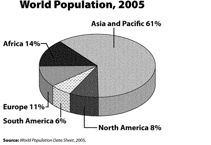
Which region has the largest percentage of the world’s population?
Africa
Europe
North America
Asia and the Pacific
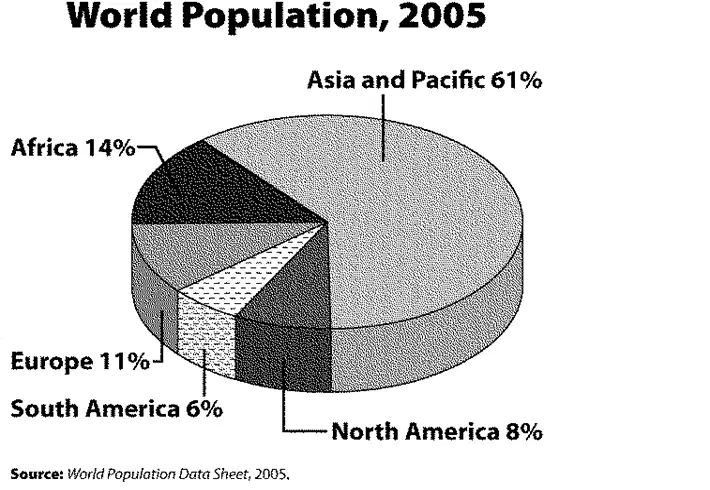
What percentage of the world’s population resides in North and South America combined?
8 percent
11 percent
14 percent
6 percent
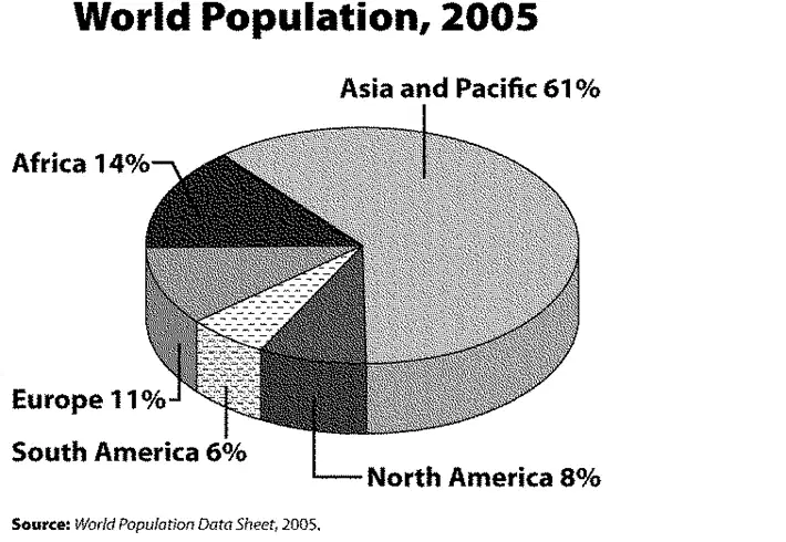
If the total world population is 6 billion, about how many people live in Asia and the Pacific?
1.6 billion
3.3 billion
3.7 billion
6.1 billion
Based on the passage about the International Date Line: The purpose of the International Date Line is to separate ____.
two consecutive calendar days
morning and night
East and West regions
the Eastern and Western Hemispheres

Based on the passage about the International Date Line: The International Date Line is located 180° from the ____.
Equator
Tropic of Cancer
Tropic of Capricorn
Prime Meridian

According to the article about the International Date Line, it is a matter of convenience and not enforced by ____.
the United States
Great Britain
international law
international treaties

According to the passage about the International Date Line: Why does the International Date Line follow a zig-zag path?
to allow for local circumstances
to make it more interesting
to follow Magellan’s path
to follow the sun

Geographers who specialize in transit can use their skills to ________.
predict weather
chase storms
plan cities
route ships

Geographers who produce maps are called ____.
cartographers
climatologists
environmentalists
publishers

Geographers who need to know zoning laws are called ________.
geologists
urban planners
cartographers
environmental managers
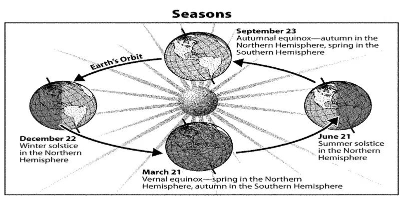
Earth’s seasons result from the ____.
Earth’s tilt
sun’s revolution around the Earth
position of the planets
Earth’s rotation
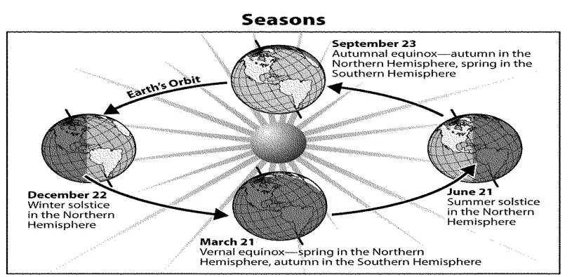
According to the diagram, spring in the Northern Hemisphere and autumn in the Southern Hemisphere means that Earth is in its ____.
autumnal equinox
summer solstice
vernal equinox
winter solstice
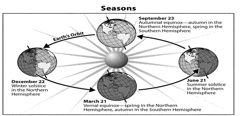
The Earth tilts ____.
23.5 degrees
25.3 degrees
30.5 degrees
50.5 degrees
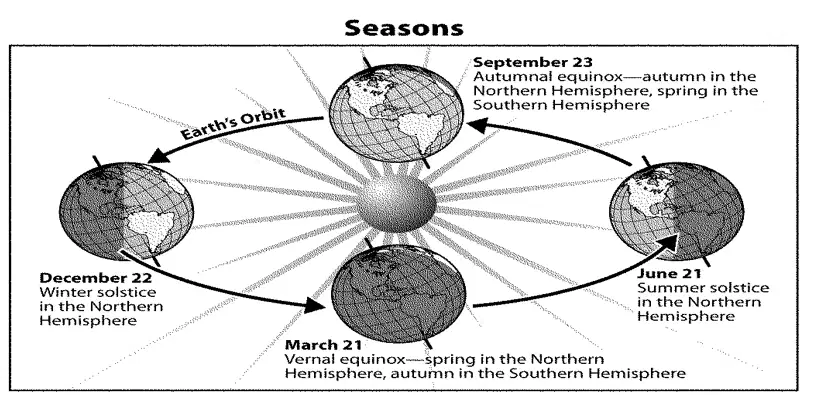
The Southern Hemisphere is angled toward the sun during the ____.
spring solstice
fall solstice
winter solstice
summer solstice
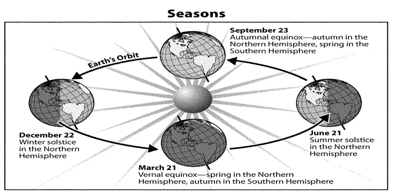
During which two days of the year does an egg balance on its tip in both the Northern and Southern Hemispheres?
winter and summer equinoxes
winter and summer solstices
vernal and autumnal equinoxes
vernal and autumnal solstices
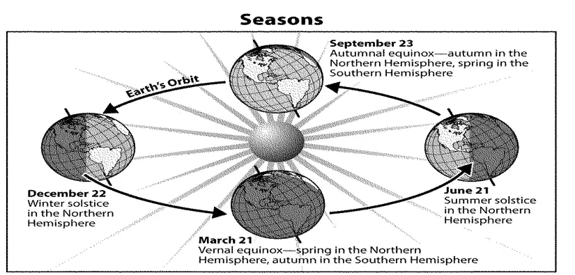
In which hemisphere are most farmers planting crops during the autumnal equinox?
Eastern Hemisphere
Southern Hemisphere
Northern Hemisphere
Western Hemisphere
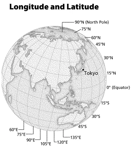
What is the location of the Equator?
0° longitude
0° latitude
90°N latitude
30°S longitude
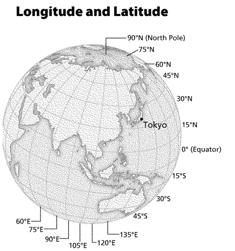
What is located at 90°N latitude?
Tokyo
North Pole
Equator
Arctic Circle
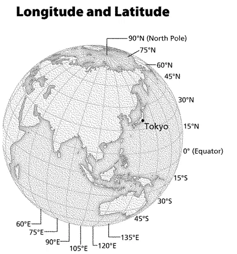
Lines of longitude run ____.
north and south of the Equator
north of the Equator
south of the Equator
from the North Pole to the South Pole
Which planet takes the longest time to complete one orbit of the sun?
Mercury
Mars
Venus
Neptune
Which is the location of the Tropic of Cancer?
23 1/2°E longitude
23 1/2°W longitude
23 1/2°N latitude
23 1/2°S latitude
Why might the U.S. government hire geographers?
to decide how land and resources might be used
to interview candidates for diplomatic positions
to build dams and reservoirs in developing countries
to study economic trends abroad
Why can Earth be compared to a melon?
Both are considered to be green in color.
Both have “rough” outer shells.
Both have several distinct layers.
Their innermost portions are rocklike.
Earth’s landforms ____.
are found only on the continents
are found on the continents and on the ocean floors
are found only on the ocean floors
have to be a certain height to be labeled “landforms”
Which geography theme describes the characteristics of a location?
Location
Movement
Region
Place
How do people affect their environment?
by changing it to meet their needs
by moving from one place to another
by mapping it
by describing their relative locations
How long does it take for Earth to make one complete circuit around the sun?
24 hours
365 1/4 Days
6 months
30 days
The position of a place on the Earth’s surface is known as ____.
Place
Location
environment
movement
Why are Geographic Information Systems (GIS) important to geographers?
They are cost-effective and can be purchased easily by geographers.
They make it easier for geographers to communicate from the field.
They are small and easy to carry.
They can gather, store, and analyze geographic information.
Every four years, which extra day is added to the calendar?
September 29
February 29
June 31
April 31
Which option is not one of the five themes of geography?
Location
Place
Human-Environment Interaction
Movement
Climate
Which statement best explains why there is a leap year?
A leap year happens every year to keep the months the same length.
A leap year adds one extra week to December because the Moon’s cycle is shorter than a month.
A leap year adds one extra day to February about every four years because Earth’s trip around the Sun is about 365.25 days long.
A leap year happens every ten years to fix the seasons.
A leap year removes a day from January to keep calendars simple.
What does the theory of plate tectonics help scientists explain?
Why the stars move across the night sky
How Earth’s crustal plates move and cause events like earthquakes, mountain building, and volcanoes
How weather fronts form in the atmosphere
Why ocean tides rise and fall each day
Which technologies assist geographers by using satellite information to make or analyze maps? Select all that apply.
GPS (Global Positioning System)
GIS (Geographic Information System)
Remote sensing
Seismograph
Optical telescope
Which sequence shows the correct order of major processes in the water cycle starting with water warming in the Sun?
Evaporation → Condensation → Precipitation → Collection/Runoff
Condensation → Evaporation → Precipitation → Collection/Runoff
Precipitation → Evaporation → Condensation → Collection/Runoff
Evaporation → Precipitation → Condensation → Collection/Runoff

