
 Worksheets
địa 12
Total questions: 150
Worksheet time: 1hrs 15mins
Vietnam lies in which region of Asia?
East Asia
South Asia
Southeast Asia
Central Asia
What is the latitude of Vietnam’s northernmost point?
23°23′N
20°30′N
21°10′N
22°15′N
Vietnam’s territory consists of which components?
Land area, sea area, offshore islands
Land area, airspace, mountainous regions
Land area, sea area, airspace
Sea area, airspace, mountainous regions
How many countries share a land border with Vietnam?
1 country
2 countries
3 countries
4 countries
Which country does not share a land border with Vietnam?
China
Laos
Thailand
Cambodia
Approximately how long is Vietnam’s coastline?
3200 km
3260 km
3400 km
3500 km
What is the width of Vietnam’s exclusive economic zone (EEZ)?
100 nautical miles
150 nautical miles
200 nautical miles
250 nautical miles
Vietnam’s southernmost point is located in which province?
Ca Mau
Kien Giang
Bac Lieu
Soc Trang
Vietnam borders which sea?
East Sea (South China Sea)
Java Sea
Sea of Japan
Red Sea
Vietnam’s land territory includes the entire mainland and which of the following?
Islands
Nearshore islands only
Offshore islands only
Archipelagos only
The sea area where the Vietnamese state exercises sovereignty as on the mainland is called
Internal waters
Territorial sea
Contiguous zone
Exclusive economic zone
Vietnam’s easternmost point is in which province?
Ca Mau
Ha Giang
Dien Bien
Khanh Hoa
To the west, Vietnam borders which countries?
Laos and Thailand
Cambodia and China
Laos and Cambodia
Laos and China
Which island district is the farthest from Vietnam’s mainland?
Hoang Sa (Paracel)
Phu Quoc
Phu Quy
Truong Sa (Spratly)
Which statement is not correct about Vietnam’s geographical location?
Located in the tropical zone
Adjacent to the East Sea (South China Sea)
Situated in the tropical monsoon region
At the center of the Indochina Peninsula
Bordering a broad tropical sea gives Vietnam which characteristic?
Abundant metallic mineral resources
Many storms and tropical depressions
Extensive coastal mangrove forests everywhere
Coastal landforms are all plains
Being in a monsoon region gives Vietnam which characteristic?
Arid savanna landscapes
Weather that changes by season
Very large annual temperature range
Extremely diverse flora and fauna solely because of climate
Being in the Northern Hemisphere’s inner tropics means Vietnam has
Climate divided into four equal seasons nationwide
A cold winter nationwide
A positive radiation balance year-round
Lush green vegetation everywhere all year
From a national defense and security perspective, Vietnam’s long land border creates difficulties primarily for
Cultural development
Attracting foreign investment
Mineral resource extraction
Safeguarding territorial sovereignty
The tropical nature of Vietnam’s climate is determined primarily by
Its position in the inner tropics
The country’s largely mountainous terrain
Relief sloping down toward the sea
Southwest foehn winds
The main cause of Vietnam’s diverse natural differentiation and the formation of distinct natural regions is
Climate and rivers
Geographical location and tectonic-structural form
Mineral resources and the sea
Monsoon winds and ocean currents
Which factor most determines the richness of Vietnam’s species composition?
Dominant mountainous terrain with complex differentiation
Humid tropical monsoon climate with diverse differentiation
Human activities
Marine influences
Vietnam has a rich endowment of mineral resources due to its geographical location. Which of the following best explains this?
Bordering vast, resource‑rich seas
Being adjacent to major metallogenic belts
Lying on the migration routes of many species
Experiencing monsoon and trade‑wind activity
What is the cultural significance of Vietnam’s geographical location?
Connection between two major metallogenic belts
A place of vibrant economic activities
Lies on international maritime routes
A meeting place of many great civilizations
Located in a region frequently affected by Asian monsoons and trade winds, Vietnam has which climatic characteristic?
A highly diverse river network
Strongly diversified terrain
Climate that varies by season
Terrain mainly of low mountains and hills
On Vietnam’s land territory, where is the interval between the two annual occurrences of the Sun at the zenith farthest apart?
The westernmost point
The northernmost point
The southernmost point
The easternmost point
The latitudinal extent of Vietnam’s territory from 8°34′N to 23°23′N indicates which characteristic?
Located in the Eastern Hemisphere
Bordering the East Sea (Biển Đông)
Prone to many natural disasters
Situated within the tropical zone (intratropical region)
With long land and sea borders, Vietnam faces the greatest challenge in which aspect?
Attracting foreign investment
Safeguarding territorial sovereignty
Ensuring adequate labor supply
Developing national culture
Vietnam’s climate is not as arid as that of most countries at similar latitudes because of which factor?
Proximity to two major metallogenic belts
Influence of air masses that move across the East Sea (Biển Đông)
Entirely within the tropical zone of the Northern Hemisphere
Nature strongly influenced by trade winds
Vietnam’s geographical advantage within Southeast Asia would be maximized by combining which modes of transportation?
Railways and seaways
Seaways and airways
Roadways and airways
Railways and roadways
Information: Vietnam lies in the eastern part of the Indochinese Peninsula; on land it borders three countries. At sea, Vietnam shares the East Sea (Biển Đông) with many other countries. The country is located on international maritime and air routes, as well as trans‑Asian road and rail corridors. Based on this information, select all statements that are correct.
The three countries bordering Vietnam by land are China, Laos, and Thailand.
Vietnam serves as a seaward gateway for several countries in the region.
The geographical location facilitates expanding exchanges and developing marine‑based economic sectors.
The geographical location provides many advantages for safeguarding national security and sovereignty.
Information: Vietnam is at the center of Southeast Asia. On land, the extreme latitudes and longitudes are 23°23′N (north), 8°34′N (south), 102°09′E (west), and 109°28′E (east). Vietnam’s maritime area extends to about 6°50′N in latitude and from about 101°E to 117°20′E in longitude in the East Sea (Biển Đông). Based on this information, select all statements that are correct.
The mainland territory extends nearly 15 degrees of latitude.
Vietnam lies entirely within the Northern Hemisphere’s tropical zone (intratropical).
Thanks to its location, Vietnam is little affected by natural disasters and climate change.
Vietnam is frequently influenced by the Asian monsoon and trade winds.
Information: Vietnam’s marine area is vast—about three times the area of its mainland. The marine environment has abundant humidity and is under frequent influence of monsoon and trade‑wind circulations. Nature is diverse and rich, typical of a humid tropical monsoon sea. Based on this information, select all statements that are correct.
The humid tropical monsoon character of the East Sea (Biển Đông) is evident in oceanographic conditions and marine biota.
Air masses passing over the sea into Vietnam contribute to high annual rainfall.
Marine resources are extremely rich and include both tropical and temperate species.
The richness of marine biodiversity is mainly due to the large area, ocean currents, and high temperatures.
Type of wind that blows year-round in Vietnam.
Westerlies of the temperate zone
Trade winds
Foehn wind
Monsoon winds
Due to the effect of the Northeast monsoon, the first half of winter in northern Vietnam usually has which weather pattern?
Cold and humid
Hot and humid
Cold and dry
Warm and dry
In winter, the monsoon blowing into Vietnam comes from which direction?
Northwest
Northeast
Southeast
Southwest
A defining characteristic of the summer monsoon in Vietnam is
Hot and dry
Hot and humid
Cold and humid
Cold and dry
In winter, the northeast monsoon is partly blocked at which mountain range in Vietnam?
Tam Diep
Hoanh Son
Bach Ma
Hoang Lien Son
During which period does the summer monsoon operate in Vietnam?
June to October
August to October
January to December
May to October
The tropical nature of Vietnam’s climate is primarily determined by
The vast influence of the East Sea
The strong influence of monsoon circulation
Its location within the tropical belt between the Tropics
The apparent motion of the Sun
Which statement reflects how the tropical monsoon climate appears through Vietnam’s landforms?
A positive radiation balance all year
Dominance of tropical biota
Strong denudation and erosion in hilly and mountainous areas
Seasonal river flow regime
During which period does the winter monsoon operate in Vietnam?
January to May
May to October
August to December
November to April
At the beginning of summer, the summer monsoon over Vietnam originates from
The high-pressure area over the North Indian Ocean
The East Sea
The subtropical high-pressure belt of the Southern Hemisphere
The Siberian High
The southwest foehn (phơn) wind makes the coastal lowlands of Central Vietnam experience
Heavy rain in autumn–winter
High solar radiation
Hot, dry weather in early summer
Highly contrasting rainfall patterns
The tropical humid air mass from the North Indian Ocean causes the Southern Lowlands of Vietnam to experience
Heavy rain in early summer
High solar radiation
Much rain in autumn–winter
Marked spatial contrasts in rainfall
In winter, the Northeast monsoon in northern Vietnam is accompanied by
Temperate westerlies
Northern Hemisphere trade winds
Southwest foehn winds
Southern Hemisphere trade winds
Which wind causes drizzle along the coastal areas and deltas of the Red River and North Central Vietnam?
Northeast winter monsoon
Northern Hemisphere trade winds
Southwest foehn winds
Southern Hemisphere trade winds
Karst topography in Vietnam primarily forms on which rock type?
Granite
Limestone
Basalt
Clay
Along the coast and deltas of northern and north–central Vietnam, drizzle commonly occurs during
The first half of winter
The second half of winter
The second half of spring
The first half of summer
Which wind type is the main cause of the dry season in Southern Vietnam?
Northeast monsoon
Northern Hemisphere trade wind
Southwest foehn wind
Southwest monsoon
Which statement is not correct about the Northeast monsoon in Vietnam?
It almost terminates at the Bach Ma Range.
It blows in intermittent bursts.
It creates a cold winter in the North.
It blows continuously throughout the winter.
At the beginning of summer, heavy rainfall in Southern Vietnam and the Central Highlands is mainly caused by which air mass?
Northern Hemisphere subtropical air mass
North Indian Ocean air mass
Southern Hemisphere subtropical air mass
Cold continental air mass from the North
Which region is most strongly affected by the Southwest foehn wind?
Tay Nguyen (Central Highlands)
South Central Coast
Northwest
North Central Coast
Which factor primarily creates the rainy season in Vietnam?
Southwest foehn wind
Northern Hemisphere trade wind
Northeast monsoon
Southwest monsoon
The Northern Hemisphere trade wind causes the climate of Vietnam’s Central Coast to have which characteristic?
Heavy rain at the start of summer
Very high solar radiation
Two distinct wet and dry seasons
Much rain in autumn–winter
In Northern Vietnam, the “Southeast monsoon” originates from which source region?
Northern Hemisphere subtropical high
Southern Hemisphere subtropical high
Siberian continental high
Moist tropical air mass over the North Indian Ocean
What is the primary factor making Vietnam’s ferralitic soils have a thick weathered layer?
Abundant heat and moisture
Prolonged rainfall
Pronounced dry conditions
Seasonal contrast in climate
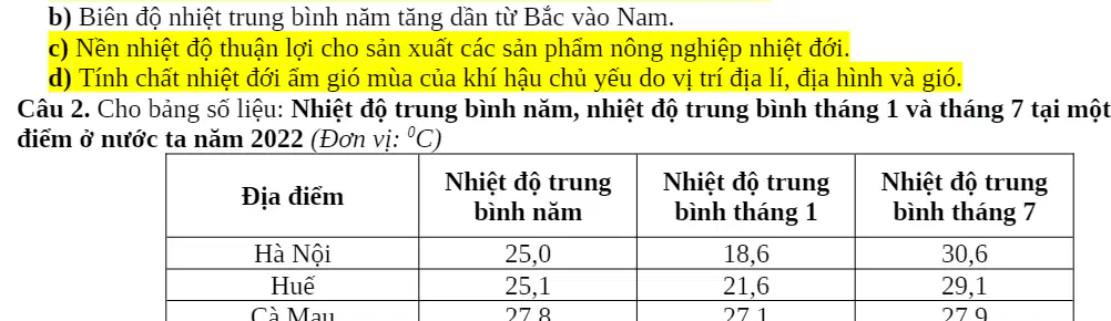
Based on the table of average temperatures at selected Vietnamese stations (columns: lowest-month average, highest-month average, annual average; stations: Ha Noi 16.6°C, 29.4°C, 23.9°C; Hue 19.9°C, 29.3°C, 25.1°C; Quy Nhon 23.3°C, 30.0°C, 25.1°C; Kien Giang/Rach Gia 25.8°C, 29.8°C, 27.1°C), which statements are correct?
All listed stations have an annual average temperature above 20°C.
The annual temperature range increases from north to south.
Temperatures are favorable for producing tropical agricultural products.
The tropical monsoon character of climate is influenced by geographic location, topography, and winds.
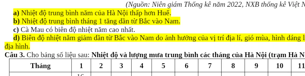
Using the 2022 table of average annual temperature and the averages for January and July at three stations (Ha Noi: 25.0°C, 18.6°C, 30.6°C; Hue: 25.1°C, 21.6°C, 29.1°C; Ca Mau: 27.8°C, 27.1°C, 29.7°C), which statements are correct?
Ha Noi’s annual average temperature is lower than Hue’s.
The average January temperature increases from north to south.
Ca Mau has the largest annual temperature range among the three stations.
The annual temperature range decreases from north to south due to geographic location, monsoon winds, national shape, and topography.
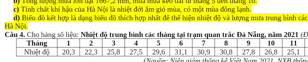
Based on the following data table of monthly mean air temperature at the Đà Nẵng observation station in 2021 (unit: °C), identify all correct statements: a) The annual mean temperature at Đà Nẵng exceeds 26°C. b) The annual temperature range at Đà Nẵng is quite large due to its location near the hot equatorial zone. c) Đà Nẵng belongs to the southern climatic region with year‑round near‑equatorial heat and has no month below 18°C. d) A column chart is the most appropriate type to represent monthly temperature at Đà Nẵng.
a) and c)
a) and b)
b) and d)
c) and d)
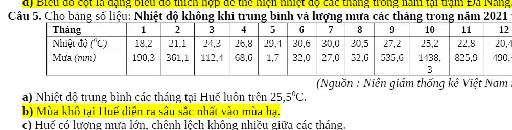
Using the 2021 monthly climate table for Huế (temperature in °C and precipitation in mm), identify all correct statements: a) Monthly mean temperatures in Huế are always above 25.5°C. b) The driest conditions in Huế occur most strongly in summer. c) Huế has high rainfall with little difference between months. d) Huế’s rainfall regime is mainly influenced by winds, topography, storms, and tropical depressions.
a) and b)
b) and d)
a) and c)
c) and d)

From the table of monthly mean air temperature in Hà Nội for 2021 (unit: °C), what is the annual mean temperature of Hà Nội in 2021 (rounded to one decimal place)?
24.8
25.3
26.1
27.0

From the table of monthly mean air temperature at the Huế meteorological station (unit: °C), what is the annual temperature range of Huế (maximum minus minimum, rounded to one decimal place)?
9.8
11.2
12.4
14.0

From the table of monthly rainfall in Huế in 2022 (unit: mm), what is the total annual rainfall for Huế in 2022 (rounded to the nearest millimetre)?
2850
3120
3914
4250
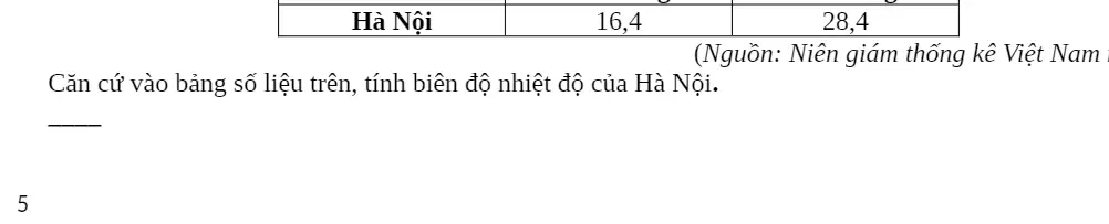
From the table of Hà Nội’s mean temperatures in January and July 2021 (unit: °C), what is Hà Nội’s temperature range between January and July?
10.6
11.2
12.0
13.5
Which statement is correct about the natural conditions of the southern region of Vietnam?
There is a cold winter during the year.
The weather is often complicated.
There is a pronounced, prolonged dry season.
The annual temperature range is large.
Which statement is correct about the climate of the northern region of Vietnam?
The annual temperature range is large.
The mean annual temperature is above 25°C.
There is a clear separation of rainy and dry seasons.
The temperature background tends toward equatorial climate.
Which statement is not correct about the north–south change of temperature in Vietnam?
The annual temperature range decreases toward the south.
The mean annual temperature increases from north to south.
The mean annual temperature decreases from north to south.
Summer temperatures differ between the two regions.
Which outstanding natural feature characterizes the Northeast and North of the Red River Delta (Bắc và Đông Bắc Bắc Bộ)?
Monsoon subequatorial climate with high temperatures year‑round.
Relief of denudation plateaus and basalt plateaus.
Mountain ranges alternating with river valleys trending northwest–southeast.
Strong activity of the Northeast monsoon, producing the coldest winters in Vietnam.
Which outstanding natural feature characterizes the South Central Coast and Southern Vietnam (Nam Trung Bộ và Nam Bộ)?
Monsoon subequatorial climate with high temperatures year‑round.
Mountain arcs with curvature trends.
High terrain with mountain ranges alternating northwest–southeast river valleys.
Strong Northeast monsoon creating the coldest winters in the country.
The typical natural landscape for the northern region is a forest belt of
Savanna and open forest.
Savanna and shrubs.
Humid subtropical forest.
Temperate monsoon forest.
The typical natural landscape for the southern region is
Humid tropical monsoon forest.
Subtropical open forest.
Dry subtropical forest.
Equatorial monsoon forest.
The tropical monsoon altitudinal belt is distributed at average elevations
In the North below 600–700 m; in the South below 900–1000 m.
In both North and South from below 600–700 m up to 900–1000 m.
In the North below 900–1000 m; in the South below 600–700 m.
In the North above 600–700 m; in the South above 900–1000 m.
The temperate monsoon belt on mountains exists only in
Trường Sơn Nam.
Trường Sơn Bắc.
Hoàng Liên Sơn.
Bạch Mã Range.
A prominent feature of the terrain in the North and Northeast (miền Bắc và Đông Bắc Bắc Bộ) is
Mainly high mountains; expanded lowlands.
Four large arc-shaped ranges; expanded lowlands.
Mainly low hills and mountains; expanded lowlands.
Mainly high mountains; diverse coastal landforms.
The soil group with the largest area in the tropical monsoon climate zone is
Alluvial soils.
Feralit soils with humus.
Feralit soils.
Old alluvial gray soils.
The differentiation of natural conditions among the sea and continental shelf, the coastal plains, and the mountainous and hilly regions reflects zonation by
North–South.
East–West.
Altitude.
West–East.
The climatic characteristic of the northern region is
Humid tropical monsoon with a cold winter.
Arid subtropical monsoon with a cold winter.
Monsoon subequatorial climate hot year‑round.
Dry tropical monsoon with a cold winter.
The influence of the Northeast monsoon is strongest in
Northwest.
Northeast.
North Central Coast.
Central Highlands.
By altitude, Vietnam’s natural environment is divided into how many belts?
5
4
3
2
The annual temperature range is higher in the North than in the South mainly because the North
has a cold winter.
experiences southwest foehn winds.
The dry season in the coastal provinces of the far southern Central Region lasts the longest in the country mainly because
the influence of hot, dry foehn winds
the influence of the northeast trade winds
the coastal relief does not receive the monsoon winds
the mountain terrain slopes steeply toward the sea
The natural differentiation between the eastern and western sides of the Southern Trường Sơn Range is mainly due to
the effect of the monsoon and the orientation of the mountain ranges
elevation and the influence of the sea
the influence of the sea and the vegetation cover
elevation and the orientation of the mountain ranges
In Vietnam, the natural environment of the Northwest differs from the Northeast in which of the following ways?
Winter arrives earlier in the low mountains
Winter comes later and ends earlier
The rainy season arrives later
Cold climatic conditions are mainly due to the northeast monsoon
A climatic difference between the Southern Region and the South Central Coast is that the Southern Region has
an earlier monsoon rainy season
an earlier rainy season
a subequatorial climate
year‑round heat
A climatic difference between the South Central Coast and the Southern Region is that the South Central Coast has
a slower onset of the rainy season
an earlier onset of the rainy season
a later rainy season
year‑round heat
The southern part of Vietnam does not have a high‑altitude monsoon wind belt because it
lies next to a wide sea area
lacks elevations above 2600 m
does not experience northeast monsoon activity
lies near the equator
A similarity in climate between the South Central Coast and the Central Highlands is
a distinct division between rainy and dry seasons
flood‑season rains occur in autumn–winter
a large annual mean temperature range
summer southwesterly foehn winds
The opposition between the rainy and dry seasons in the Central Highlands and the coastal plains of the South Central Coast is mainly due to the influence of
the Hoành Sơn Range together with monsoon influence
the Trường Sơn Range together with monsoon influence
the Bạch Mã Range together with monsoon influence
the Hoàng Liên Sơn Range together with the influence of the sea
Which primary cause makes the Red River Delta and the Northeastern Region of Northern Vietnam strongly affected by the northeast monsoon?
Elevation and the orientation of mountain ranges
Geographical location and the orientation of mountain ranges
Geographical location and terrain elevation
Orientation of mountain ranges and the East Sea
The annual temperature range is larger in the North than in the South mainly because the North
is near the tropic and has trade winds
has a cold winter and low terrain
has southwesterly foehn winds and high terrain
is near the tropic and has a cold winter
A climatic difference between the South Central Coast and the Southern Region is that the South Central Coast has
a slower onset of the rainy season
an earlier onset of the rainy season
a subequatorial climate
a distinct rainy and dry season
Huế has a large annual average rainfall mainly because of
the intertropical convergence zone, storms, and northeasterly winds
its coastal position, trade winds, and the intertropical convergence zone
fronts, the northeast monsoon, and a warm current
trade winds, storms, and windward mountain terrain
Which primary cause leads to a high rate of evaporation in Ho Chi Minh City?
High temperatures year‑round and a pronounced dry season
Proximity to the equator and global warming
Trade‑wind activity with frequent heat waves
Forest area decline and year‑round high temperatures
The main factors forming centers of heavy and light rainfall in Vietnam are
latitude and the monsoon
relief and the monsoon
the monsoon and ocean waves
the monsoon and biota
Given the following description: average elevations below 600–700 m in the North and below 900–1000 m in the South; hot summers with monthly means above 25∘C ; humidity varies by season and region; two main soil groups are alluvium in the deltas and ferralitic soils in low hills. Which statements are correct?
These are characteristics of the humid subtropical monsoon belt
Temperate forest ecosystems predominate
Hot summers are due to geographical location and the activity of the summer monsoon
Ferralitic soils predominate mainly due to the effects of relief and climate
Read the excerpt: “Average annual temperature is above 20∘C (except high mountainous areas), in which the South usually has a higher average temperature than the North. Each year, our country receives a large amount of solar radiation; total sunshine duration ranges from 1,400 to 3,000 hours per year.” Which statements are correct?
The average annual temperature in the North is higher than in the South.
The climate has tropical characteristics.
The country receives large solar radiation mainly because most of the territory lies near the Equator.
High temperatures are due to the country lying within the inner tropics, where the angle of solar incidence is large.
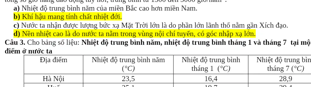
Given the table of temperature data for three locations in Vietnam: Hanoi — annual mean 23.5∘C , mean January 16.4∘C , mean July 28.9∘C ; Hue — annual mean 25.1∘C , mean January 21.9∘C , mean July 29.7∘C ; Ho Chi Minh City — annual mean 27.1∘C , mean January 25.7∘C , mean July 27.1∘C . Which statements are correct?
Hue has the largest annual temperature range because of its geographical position.
The annual mean temperature increases from the North toward the South.
The annual temperature range decreases from the North toward the South.
Hanoi’s large annual temperature range is due to the influence of the Northeast monsoon.
Read the information: Sunshine hours in Vietnam differ strongly among regions; the sunniest places have about twice as many hours as the least sunny. In general, areas north of 16∘ N have fewer sunshine hours than the South; the total ranges from 1,400 to 3,000 hours in the country, and from 2,000 to 3,000 hours in the South. Which statements are correct?
Because Vietnam lies within the inner tropics, the country has a large total number of sunshine hours.
Sunshine hours vary from north to south mainly due to differences in topographic shading.
The main reason for territorial differences in sunshine hours is solely the activity of the Northeast monsoon.
The South has more sunshine hours than the North due to its latitude and its limited influence from the Northeast monsoon.
Given: The month of peak rainfall is August in the North, September in the North Central Coast, October–November in the South Central Coast, and September–October in the Central Highlands and the South. Which statement best explains these differences?
The North receives heavy summer rain mainly due to the Northern Hemisphere trade winds and mountain barriers.
The peak rainfall month shifts later from North to South because the Intertropical Convergence Zone and tropical storms move southward over time.
The rainy season in the South Central Coast arrives later mainly because this region lies on the leeward side of mountains throughout the year.
The ITCZ forms between the air masses of the North Indian Ocean and the Southern Hemisphere subtropics.
What is the principal cause of the rapid decline in the area of natural forest in Vietnam?
Climate change
Small area of planted forests
Overexploitation
War
Which statement about Vietnam’s forest resources is not correct?
The total forest area is increasing.
Forest resources are still being degraded.
The area of rich forest accounts for a large proportion.
Forest quality has been rehabilitated in many places.
To limit soil erosion on sloping land in mountainous regions, which cultivation technique should be applied?
Prevent shifting cultivation and nomadism
Apply agroforestry
Protect forests and forest land
Build terraced fields and fish-scale pits
What is the greatest natural limitation on agricultural development in the Mekong Delta?
Increasing floods and tidal surges
Declining forest resources
Large areas of acid sulfate and saline soils
Limited mineral resources
Which measure is used to protect soils in Vietnam’s lowland deltas?
Build terraced fields
Control salinization
Plant trees in contour strips
Dig fish-scale pits
Which statement correctly describes Vietnam’s forest resources at present?
Forest quality has been fully restored.
Poor and regenerating forests occupy a large proportion.
Forest area is declining rapidly and continuously.
Rich forests occupy a large proportion.
High biodiversity is shown by
the distribution of organisms
the development of organisms
a large forest area
precious genetic resources
The main cause leading to water environmental pollution is
untreated solid and liquid waste
the diverse development of craft villages
rapid industrial development
a large and rapidly growing population
Vietnam’s high biodiversity is reflected in
the distribution of organisms
the development of organisms
a large forest area
diverse ecosystem types
The decline of Vietnam’s biological resources is manifested in
an increase in the number of individuals of animal and plant species
an increase in the number of individuals and species of wild animals
primary forest ecosystems occupying a large area
some animal and plant species at risk of extinction
Which agricultural activity has a high risk of leading to soil resource degradation?
intensifying cultivation and increasing crops per year
expanding wet‑rice cultivation
using pesticides and chemical fertilizers
applying different farming techniques
A sign of soil resource degradation in mountainous areas is
salinization
acid sulfate (alum) formation
gleying
erosion
A natural cause of the decline of Vietnam’s biological resources is
agricultural development
climate change
war destruction
wildlife hunting
Read the situation: Environmental pollution in a province is urgent, with both air and water pollution occurring. Air pollution is most notable in big, densely populated cities. Emissions from industry and household activities are the main causes of air pollution. The increase in wastewater from economic sectors and domestic sources are direct causes of water pollution. Strengthening the use of fossil energy is suggested as a measure to reduce air pollution. Which statements below are correct according to the situation?
Air pollution mainly occurs in large, densely populated cities.
Industrial and household emissions are the main causes of air pollution.
Increasing wastewater from economic sectors and households directly causes water pollution.
Strengthening the use of fossil energy helps reduce air pollution.
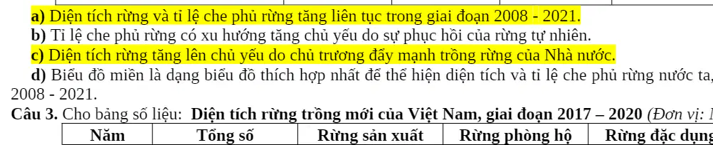
Based on the table: Forest area and forest cover of Vietnam, 2008–2021. Data: 2008 — total forest area 13,118.8 thousand ha, forest cover 38.7%; 2012 — 13,862.0 thousand ha, 40.7%; 2018 — 14,491.3 thousand ha, 41.7%; 2021 — 14,745.2 thousand ha, 42.0%. Which statements are correct?
Forest area and forest cover rate increased continuously during 2008–2021.
The forest cover rate increased mainly due to the recovery of natural forests.
Forest area increased mainly due to policies promoting afforestation.
An area chart is the most suitable graph type to show both forest area and forest cover rate over time.
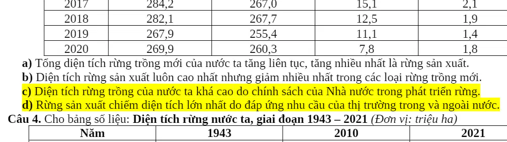
Based on the table: Newly planted forest area of Vietnam, 2017–2020 (thousand ha). Totals and by type — 2017: total 284.2 (production 267.7, protection 15.9, special‑use 0.6); 2018: total 282.1 (production 267.7, protection 12.1, special‑use 2.4); 2019: total 267.9 (production 255.4, protection 11.4, special‑use 1.1); 2020: total 269.9 (production 260.3, protection 9.6, special‑use 0.0). Which conclusion best fits the data?
The total newly planted forest area increased continuously, with production forest increasing the most.
Production forest area was always the highest but decreased the most among the forest types.
Vietnam’s newly planted forest area is high mainly due to government forest‑development policies.
Production forests occupy the largest area because they meet domestic and export market demand.

Based on the following data for Vietnam’s forest area by type and year, select all statements that are appropriate. Data table (million ha): Year 1943 — Total forest area 14.3, Natural forest 14.3, Planted forest 0.0; Year 2010 — Total 13.4, Natural 10.3, Planted 3.1; Year 2021 — Total 14.7, Natural 10.1, Planted 4.6.
The country’s total forest area increased, planted forest area increased, and natural forest area decreased.
The total forest area increased but forest resources have declined in quality.
Natural forest area decreased due to exploitation, improper use, and forest fires.
A pie chart is the most appropriate chart type to show Vietnam’s forest area for the period 1943–2021.
Given that Vietnam’s total forest area in 2021 was 14.7 million ha and natural forest area was 10.1 million ha, what percentage of the total forest area was natural forest? Round to one decimal place.
54.8%
61.5%
68.7%
72.1%

Using the table below, calculate the absolute change in Vietnam’s total forest area from 1943 to 2021. Round to the nearest tenth of a million hectares. Data table (million ha): Year 1943 — Total forest area 14.3; Year 2021 — Total forest area 14.7.
0.2 million ha
0.3 million ha
0.4 million ha
0.5 million ha

Vietnam’s total forest area in 2021 was 14.7 million ha, of which planted forest area was 4.6 million ha. What percentage of the total forest area was planted forest? Round to one decimal place.
27.9%
31.3%
34.1%
37.5%

From the table below, by what percentage did Vietnam’s total forest area increase from 1943 to 2021? Round to the nearest tenth of a percent. Data table (million ha): Year 1943 — Total forest area 14.3; Year 2021 — Total forest area 14.7.
1.9%
2.3%
2.8%
3.4%
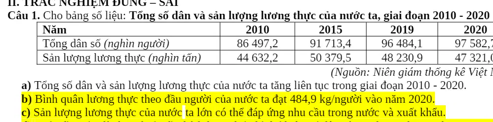
Based on the following data for Vietnam during 2010–2020, select all statements that are correct. Data table: Year — 2010, 2015, 2019, 2020; Total population (thousand people) — 86,497.2; 91,713.4; 96,208.4; 97,582.7; Food production (thousand tons) — 44,632.2; 50,379.5; 48,230.9; 47,321.6.
Both total population and food production increased continuously from 2010 to 2020.
Per‑capita food output in 2020 was 484.9 kg/person.
Vietnam’s food production is large enough to meet domestic demand and allow for exports.
An area chart is the most appropriate chart type to show total population and food production for 2010–2020.
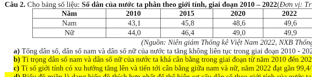
Using the following data on Vietnam’s population by sex for 2010–2022, select all statements that are correct. Data table (million people): Males — 2010: 43.1, 2015: 45.8, 2019: 48.2, 2022: 49.7; Females — 2010: 44.0, 2015: 46.4, 2019: 47.9, 2022: 49.1.
Total population, the male population, and the female population increased non‑continuously during 2010–2022.
The shares of males and females in the population were fairly balanced during 2010–2022.
The sex ratio has been rising and reached 99.4 males per 100 females in 2022.
An area chart is the most appropriate chart type to show the sex composition of the population for 2010–2022.
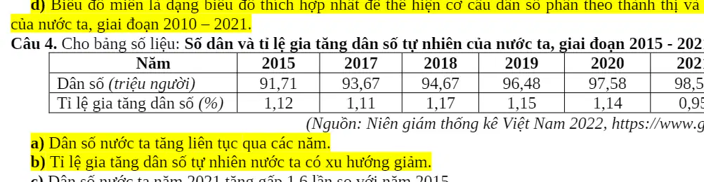
Use the following table to evaluate the statements for Vietnam during 2015–2021. Select all statements that are correct. Table: Population (million people) and natural increase rate (%) of Vietnam, 2015–2021 — Year: 2015 2016 2017 2018 2019 2020 2021; Population (million): 91.71 93.67 94.67 96.08 97.08 98.08 98.51; Natural increase rate (%): 1.12 1.11 1.17 1.17 1.16 1.04 0.95.
The country’s population increased continuously each year.
The natural increase rate shows an overall decreasing tendency.
The 2021 population was 1.6 times the 2015 population.
A combined chart (columns for population and a line for the rate) is most suitable to present both indicators together for 2015–2021.
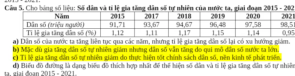
Using the same table for Vietnam, 2015–2021 (Population in million people: 91.71, 93.67, 94.67, 96.08, 97.08, 98.08, 98.51; Natural increase rate in %: 1.12, 1.11, 1.17, 1.17, 1.16, 1.04, 0.95), select all statements that are correct.
Population increased every year, while the natural increase rate tended to decline.
Although the natural increase rate decreased, total population still rose because the population base is large.
The decline of the natural increase rate reflects effective population policy and economic development.
A line chart alone is the most appropriate chart to present both the population and the natural increase rate for 2015–2021.
Given Vietnam’s land area is 331,212 km2 and its 2022 population is 99.47 million people, what is the national population density in 2022 (people per km2)? Round to the nearest whole person per km2.
286 people/km^2
300 people/km^2
314 people/km^2
328 people/km^2

From the table: Total population of Vietnam (million people) — 1990: 66.9; 2000: 77.6; 2010: 92.2; 2015: 98.5; 2021: 98.5. By how many million people did the population increase in 2021 compared with 1990? Round to one decimal place.
28.4 million
31.6 million
33.0 million
35.2 million
In 2021, Vietnam’s urban population was 36.6 million and its rural population was 61.9 million. What was the rural share of the total population in 2021? Round to one decimal place (%).
59.5%
61.2%
62.9%
64.7%

Use the table: Vietnam’s crude birth rate (‰) and crude death rate (‰) — Year: 2010, 2015, 2019, 2020, 2021, 2022; Birth rate: 17.1, 16.2, 16.3, 16.3, 15.7, 15.2; Death rate: 6.8, 6.8, 6.3, 6.06, 6.4, 6.1. By how many per-thousand (‰) did the natural increase rate decrease from 2010 to 2022?
0.9‰
1.2‰
1.5‰
2.0‰
The quality of our country's labor force is increasingly improved mainly due to
an increasing number of workers in joint-venture companies.
the strong development of rural industry and services.
achievements in the economy, culture, education, and health.
opening many more training and career-orientation centers.
Which area in our country has the highest unemployment rate?
Midlands and hills
Plateaus
Urban areas
Rural areas
Which of the following is not an advantage of our country's labor force?
Quickly absorbing science and technology
Large in number and increasing fast
Hardworking with much production experience
Highly qualified workers are still few
Which statement is not correct about our country's labor force?
Abundant and growing rapidly
High qualifications predominate
Unevenly distributed
Lacking industrial discipline
Workers in our country have the most production experience in which field?
Industry
Trade
Tourism
Agriculture
The labor-use structure by economic sector in our country is shifting toward
decreasing the share of labor in services and industry.
increasing the share of labor in agriculture, forestry, and fisheries.
increasing the share of labor in industry and construction.
decreasing the share of labor in industry and construction.
How is the employment structure by technical-professional qualification in our country changing?
Trained workers decrease, primary-level workers increase rapidly
Untrained workers decrease, intermediate-level workers decrease rapidly
Trained workers increase, untrained workers decrease
Untrained workers increase, those with college or higher decrease
Which statement is not correct about the quality of our country's labor force?
Hardworking with experience in agriculture
Much experience in industrial production
Scientific and technical level is increasingly improved
Able to quickly absorb scientific and technical advances
The main measure to solve the current underemployment situation in our country is
focusing on intensive farming with more crops per year.
diversifying economic activities.
concentrating labor in cities.
developing high-technology industries.
Which statement correctly describes our country's current labor structure by sector?
The services sector tends to decrease.
It changes rapidly compared with other countries.
A large share of workers remains tied to agriculture.
It is changing toward industrialization.
The main measure to solve urban unemployment in our country today is
building large-scale industrial plants.
international labor cooperation to export labor.
redistributing the labor force nationwide.
promoting the development of industry and services in urban areas.
To use surplus labor time effectively in rural areas, the best measure is
reviving traditional crafts.
intensive farming with more crops per year.
developing the household economy.
reclaiming land to expand cultivated area.
What is the main reason why the average income of workers in our country is low compared with the world?
Labor productivity is not high.
The share of agricultural labor is still large.
Infrastructure is backward.
Workers lack industrial discipline.
Due to the open-door and integration policy, the labor structure by economic sector has changed in which direction?
State sector decreases, non-state increases, and foreign-invested sector increases
State sector decreases, non-state decreases, and foreign-invested sector increases
State sector increases, non-state decreases, and foreign-invested sector decreases
State sector increases, non-state increases, and foreign-invested sector decreases
What is the significance of labor export in addressing employment issues in our country?
It redistributes population and labor.
It diversifies production activities.
It limits unemployment and underemployment.
It diversifies domestic forms of labor training.
The reason employment has become an economic–social issue that requires attention in our country today is
The national rates of unemployment and underemployment remain high.
The urban population and urbanization rate are still increasing rapidly.
The population is increasing rapidly while the growth rate is declining.
National unemployment and underemployment are decreasing.
Which statement is NOT correct about the characteristics of our country's labor force?
The labor source is abundant and still increasing.
The number of skilled technical workers is still small.
Labor quality is being improved.
The workforce with high qualifications is large.
Labor tends to shift from the State sector to the foreign-invested sector because
The State sector is inefficient.
Due to the impact of industrialization and modernization.
The country follows an open economy that attracts foreign investment.
The economy is gradually transitioning to a market mechanism.
What key advantage does our country's young labor force create?
It creates a strong pull for foreign investors.
It quickly absorbs advanced technologies and techniques.
It provides a vast consumer market and a highly skilled workforce.
It supplies abundant labor that attracts significant investment.
The current change in labor structure among economic sectors in our country is mainly due to
Implementation of population and family planning policies.
Mechanization of agriculture reducing labor needs.
Increasingly rational distribution of population and labor among regions.
Economic restructuring toward industrialization.
The main reason underemployment remains severe in rural areas of our country is
The share of highly skilled labor is low.
Rural-to-urban migration.
Agricultural production is seasonal.
Agricultural production is dominated by subsidies.

