Worksheets
Weather Check-In Review 25/26
Total questions: 44
Worksheet time: 26mins
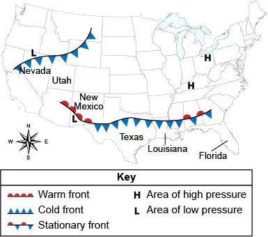
Directions: The weather map below shows a 24-hour forecast for the United States. Use the weather map and your knowledge of science to answer any questions that follow.
According to the weather map, what weather is northern Louisiana most likely to experience in the next 24 hours?
average weather
warm weather
cold weather
hot weather
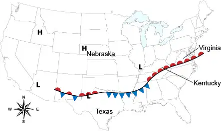
A weather map for the United States is shown. Use the weather map and your knowledge of science to answer any questions that follow.
The "L" and fronts with small semicircles on them in Kentucky and Virginia brought
rain and warm weather to Kentucky and Virginia.
rain and cold weather to Kentucky and Virginia.
clear, warm weather to Kentucky and Virginia.
clear, cold weather to Kentucky and Virginia.
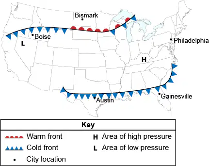
Directions: The picture below shows a weather map of the United States. Use the image to answer any questions that follow.
Where is it least likely to rain in the next 24 hours?
Austin
Boise
Gainsville
Philadeplhia
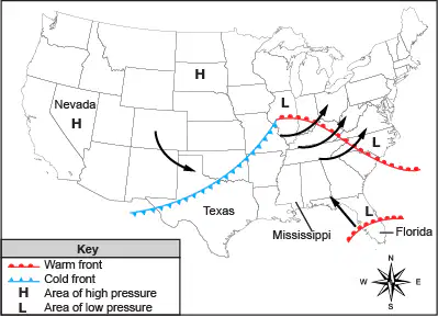
Directions: The weather map below shows a 24-hour forecast for the United States. Use the weather map and your knowledge of science to answer any questions that follow.
The cold front is moving much faster than the weaker warm front moving into Florida. According to the weather map, the cold front and the remains of the warm front will collide in the Southeast in the next 48 hours. What weather will Mississippi experience when this occurs?
clear weather and sunshine
clear weather and wind
cloudy weather and rain
cloudy weather and snow
Directions: The weather map below shows a 24-hour forecast for the United States. Use the weather map and your knowledge of science to answer any questions that follow.
According to the weather map, what type of weather is Nevada most likely to experience in the next 24 hours?
clear weather
rainy weather
sleet
snow
Directions: The weather map below shows a 24-hour forecast for the United States. Use the weather map and your knowledge of science to answer any questions that follow.
According to the weather map, what type of weather is the East Coast most likely to experience in the next 24 hours?
warm, dry weather
cold, dry weather
warm, wet weather
cold, wet weather
Directions: The weather map below shows a 24-hour forecast for the United States. Use the weather map and your knowledge of science to answer any questions that follow.
According to the weather map, what weather is central Florida most likely to experience in the next 24 hours?
warm, dry weather
cold, dry weather
warm, wet weather
cold, wet weather
Directions: The weather map below shows a 24-hour forecast for the United States. Use the weather map and your knowledge of science to answer any questions that follow.
According to the weather map, what type of weather is central Texas most likely to experience in the next 24 hours?
continuing average weather
a change to warmer weather
a change to cooler weather
continuing hot weather
Directions: The weather map below shows a 24-hour forecast for the United States. Use the weather map and your knowledge of science to answer any questions that follow.
Select the two conditions that describe the forecast for the East Coast for the next 24 hours
average
clear
warm
dry
wet
Jamie recorded the temperature from Monday through Thursday. It was over 85°F every day. If there is no change to the current weather pattern, what will be the most likely temperature on Friday?
61°F
68°F
74°F
87°F
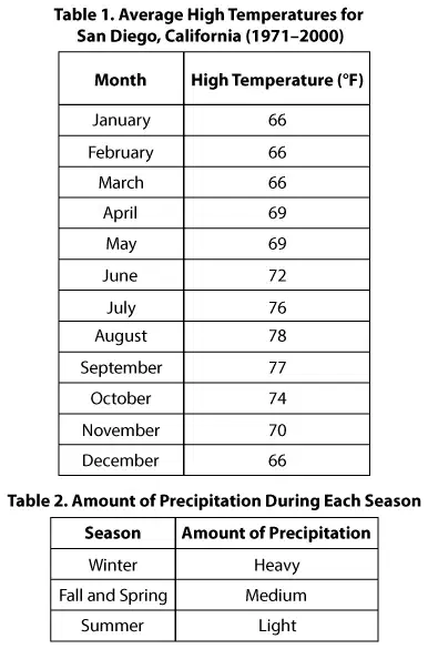
Students living in San Diego, California, are studying weather patterns. The students find the two data tables shown below.
The students also find the following dates for seasons in the Northern Hemisphere:
Winter: December 21–March 20
Spring: March 20–June 21
Summer: June 21–September 22
Fall: September 22–December 21
The students are planning an outdoor nature investigation. They want the investigation to take place in dry weather.
Use the drop-down menus to complete the sentence below.
The students should set up their investigation during (a) because this season is the driest since it has (b) rainfall.
Students living in San Diego, California, are studying weather patterns. The students find the two data tables shown below.
The students also find the following dates for seasons in the Northern Hemisphere:
Winter: December 21–March 20
Spring: March 20–June 21
Summer: June 21–September 22
Fall: September 22–December 21
Which of the following best describes San Diego's summer climate?
The summers in San Diego are warm with heavy rain.
The summers in San Diego are warm with light rain.
The summers in San Diego are cool with heavy rain.
The summers in San Diego are cool with light rain.
Students living in San Diego, California, are studying weather patterns. The students find the two data tables shown below.
The students also find the following dates for seasons in the Northern Hemisphere:
Winter: December 21–March 20
Spring: March 20–June 21
Summer: June 21–September 22
Fall: September 22–December 21
Choose TWO statements that tell which patterns occur in the data in Table 1 and Table 2.
Temperatures are lowest in rainy months.
Temperatures are highest in rainy months.
Temperatures decrease from January to June.
Temperatures increase from August to December.
Temperatures decrease from August to December.

Ann Arbor, Michigan, is a city in the United States. Ann Arbor has winter, spring, summer, and fall seasons. The temperature and precipitation change during the different seasons. Precipitation is any water from the sky: rain, snow, sleet, or hail. The table shows weather data for each season.
From the spring to the summer, it will likely get (a) and (b) . From the fall to the winter, it will likely get (c) and (d) .
Ann Arbor, Michigan, is a city in the United States. Ann Arbor has winter, spring, summer, and fall seasons. The temperature and precipitation change during the different seasons. Precipitation is any water from the sky: rain, snow, sleet, or hail. The table shows weather data for each season.
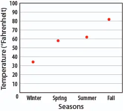
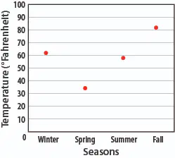
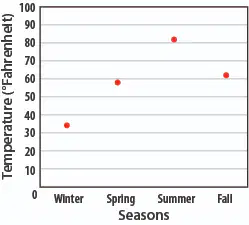
Which graph correctly shows the data from the table?


The table shows weather data for Redwood City, California.
Which sentence best compares Ann Arbor and Redwood City in the winter?
It is warmer and wetter in Ann Arbor than in Redwood City in the winter.
It is colder and drier in Ann Arbor than in Redwood City in the winter.
It is colder and wetter in Ann Arbor than in Redwood City in the winter.
It is warmer and drier in Ann Arbor than in Redwood City in the winter.

The table shows weather data for Redwood City, California.
Which sentence about Ann Arbor, Michigan, is correct?
The summer season has the most precipitation.
The spring season has the most precipitation.
The fall season has the warmest temperatures.
The winter season has the warmest temperatures.

The table shows weather data for Redwood City, California.
How does the weather change from fall to winter?
The weather gets warmer and drier.
The weather gets warmer and wetter.
The weather gets cooler and drier.
The weather gets cooler and wetter.
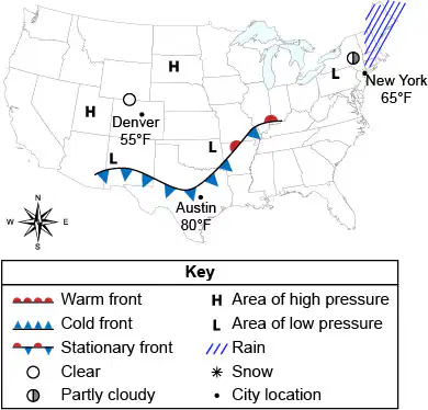
Directions: The weather map below shows a 24-hour forecast for the United States. Use the weather map and your knowledge of science to answer any questions that follow.
In the next 24 hours, Austin will most likely experience
an increase in temperature and it will rain.
a decrease in temperature and it will rain.
an increase in temperature and it will snow.
a decrease in temperature and it will snow.
Directions: The weather map below shows a 24-hour forecast for the United States. Use the weather map and your knowledge of science to answer any questions that follow.
Which area of the country is experiencing partly cloudy skies?
the Northeast
the Northwest
the Southeast
the Southwest
Directions: The weather map below shows a 24-hour forecast for the United States. Use the weather map and your knowledge of science to answer any questions that follow.
Select the three weather conditions that Denver is experiencing.
clear
cloudy
cool
dry
wet
Which type of weather occurs when clouds form near the ground?
foggy
rainy
sunny
windy
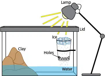
Directions: The following picture shows a model of the water cycle in an aquarium. Use the model to answer any questions that follow.
Which of the following is the cup in the picture NOT modeling?
clouds
rainfall
the heat produced by the Sun
condensation caused by cooled water
Directions: The following picture shows a model of the water cycle in an aquarium. Use the model to answer any questions that follow.
What would happen if the lamp were removed from this model?
The temperature of the aquarium would greatly increase.
The clay in the mountain would harden more quickly.
The ice would continue to stay frozen in the cup and not change states.
The water at the bottom of the aquarium would evaporate more slowly.
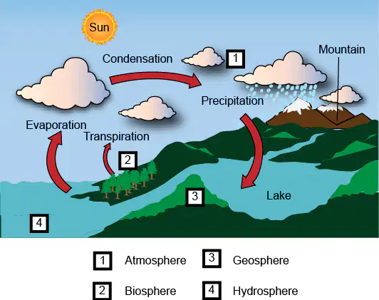
A student makes a poster of the water cycle for a presentation for his class, as shown. The four major systems of Earth are represented by numbers, and the various processes of the water cycle are labeled in his model.
While the energy from sunlight is the force that drives the water cycle, another force propelling the water cycle is gravity. Gravity is the force of attraction between two objects. The gravity exerted by Earth pulls matter downward to Earth's center. Also, the path of the water cycle interconnects many of Earth's systems. Water in different states is transferred between systems in a constant cycle.
Sam planned an investigation to determine the conditions that lead to the cycling of water. What factor that drives the cycling of water must be included in Sam's investigation?
plants and trees in the biosphere
the surface features of Earth
water in the hydrosphere
the energy from the sun
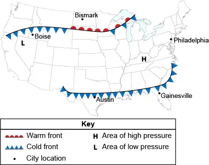
Directions: The picture below shows a weather map of the United States. Use the picture to answer any questions that follow
Which change is most likely going to happen in the next 24 hours?
The Philadelphia area will experience a storm.
The skies will clear in the Gainesville area.
The temperature will drop in Austin.
The temperature will rise in Boise.
Directions: The picture below shows a weather map of the United States. Use the picture to answer any questions that follow
Select the three cities in which the temperature will most likely drop in the next 24 hours
Austin
Bismarck
Boise
Gainsville
Philadelphia
What would most likely increase the amount of condensation observed as dew?
Increased evaporation due to an increase in heat energy from the sun.
Decreased evaporation due to a decrease in heat energy from the sun.
Increased precipitation due to an increase in heat energy from the sun.
Decreased precipitation due to a decrease in heat energy from the sun.
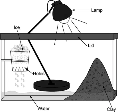
The picture below shows a model of the water cycle in an aquarium.
What would happen if a second lamp were added to the experiment?
There would be less condensation produced.
The clay would soak up more of the water.
The ice would melt slower, producing fewer drops of water.
The ice would melt and water would evaporate faster.
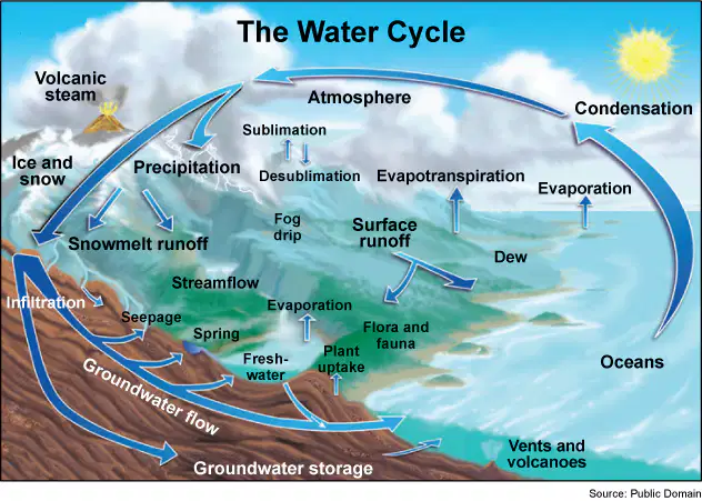
The diagram shows the water cycle.
How does the Sun help to maintain the amount of freshwater found on land in the water cycle?
The Sun causes salt water to filter through fine soils on land and to collect in large pools.
The Sun causes frozen water in glaciers to regularly transpire and release freshwater onto land.
The Sun causes freshwater to condense deep in the bottoms of lakes so that it never evaporates.
The Sun causes freshwater to evaporate from salt water and some of the freshwater precipitates back onto land.
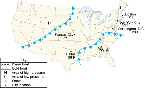
The picture shows a 24-hour weather map of the United States.
What will most likely happen to Atlanta's temperature in the next 24 hours?
The temperature will go up because a cold front will move through.
The temperature will go up because a warm front will move through.
The temperature will go down because a cold front will move through.
The temperature will go down because a warm front will move through.
The main source of energy that drives the water cycle comes from
hydrothermal vents.
atmospheric pressure.
convection currents.
the Sun
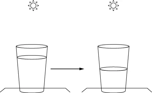
The picture below shows what happens when a glass of water is left in the sunshine for a period of time.
Which process can a scientist explain with this model?
boiling
condensation
evaporation
melting

The table shows two different sets of weather conditions that can be encountered by a hurricane.
Which set of conditions will decrease size and strength of the hurricane and why?
the conditions in Set 2 because the warm water will cause less water to evaporate into the atmosphere, weakening the hurricane, and the weak vertical winds will break up the hurricane
the conditions in Set 2 because the warm water will cause more water to evaporate into the atmosphere, weakening the hurricane, and the weak vertical winds break up the hurricane
the conditions in Set 1 because the cold water will cause less water to evaporate into the atmosphere, weakening the hurricane, and the strong vertical winds will break up the hurricane
the conditions in Set 1 because the cold water will cause more water to evaporate into the atmosphere, weakening the hurricane, and the strong vertical winds break up the hurricane
The diagram shows the model that Dalitso made to represent the water cycle. Dalisto put her model outside in a sunny location and left the model overnight.
Pick three parts of the water cycle that Dalitso can demonstrate using her model.
runoff
evaporation
precipitation
transpiration
condensation
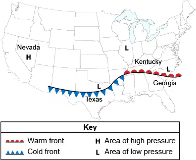
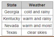
The weather map shows a 24-hour forecast for the United States.
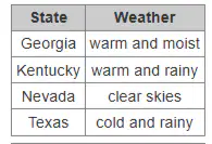
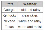
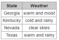
Which table correctly lists the most likely type of weather each state will experience?
Which describes the processes involved in causing rain?
Warm air moves in below cool air, pushing the cool air up, which causes clouds to form and rain to fall.
Cool air moves in above warm air, pushing the warm air down, which causes clouds to form and rain to fall.
As warm air rises, it cools, causing water to condense on dust particles and form clouds. The water eventually falls as rain.
As cool air rises, it warms, causing water to condense and form clouds. The water molecules eventually fall as rain.
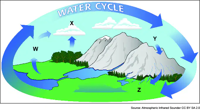
Jen designed an investigation to determine the conditions that lead to the cycling of water. She started by drawing the diagram shown. Which statement best describes how the Sun affects the process found at Y?
Which statement best describes how the Sun affects the process found at Y?
The Sun causes water to dissolve into the atmosphere where it forms clouds. Water falls from the clouds in the process of precipitation.
The Sun causes water to dissolve into the atmosphere where it forms clouds. Water falls from the clouds in the process of condensation.
The Sun causes water to evaporate into the atmosphere where it forms clouds. Water falls from the clouds in the process of precipitation.
The Sun causes water to evaporate into the atmosphere where it forms clouds. Water falls from the clouds in the process of condensation.
Which best explains how the Gulf Stream affects North Carolina’s coast?
It causes very hot temperatures and moves hurricanes toward the coast during winter.
It causes very cold temperatures and moves hurricanes toward the coast during winter.
It causes moderate temperatures during winter and moves hurricanes toward the coast during summer.
It causes moderate temperatures during winter and moves hurricanes away from the coast during summer.
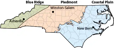
The map shows the regions of North Carolina.
Which region is most likely to experience milder winter climates?
the coastal plain, because it is closest to the ocean
the piedmont, because it receives the most sunlight
the piedmont, because it is between the mountains and coast
the coastal plain, because the mountains help prevent cold weather from reaching it
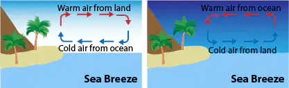
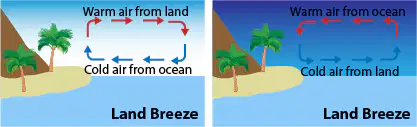
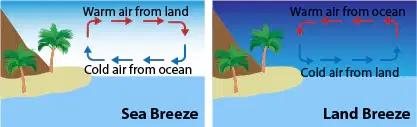
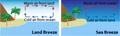
Which best explains the difference between a sea breeze and a land breeze?
A sea breeze blows toward the land during the day, and a land breeze blows toward the sea at night.
A sea breeze blows toward the sea during the day, and a land breeze blows toward the land during the night.
A sea breeze blows toward the land during the night, and a land breeze blows toward the sea during the day.
A sea breeze blows toward the sea during the night, and a land breeze blows toward the land during the day.
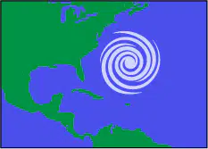
The image shows a hurricane off the coast of North Carolina.
When are hurricanes most likely to form near North Carolina?
when ocean water temperatures are the coldest in summer and early fall
when ocean water temperatures are the warmest in winter and early spring
when ocean water temperatures are the warmest in summer and early fall
when ocean water temperatures are the coldest in winter and early spring
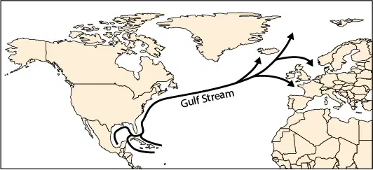
The map shows the sea surface current known as the Gulf Stream.
The Gulf Stream carries (a) water along the eastern seaboard. During cooler months, (b) air moving off of the water from the Gulf Stream moves onto land, helping to make temperatures (c) .
The differences of temperatures on land and water cause wind movements near coastal areas. Which image correctly classifies the breezes caused from temperature differences?