
 Worksheets
Social Studies Test Prep
Total questions: 75
Worksheet time: 1hrs 10mins
What are the "Three Gs," the reasons that many Europeans explored the Americas? Choose all that are correct.
God
Glory
Gold
Greed
Did Columbus meet the goals set out for his voyage by the king and queen? Why or why not?
Yes, because he found land that was good for farming.
Yes, because he traded with American Indians for furs.
No, because he did not find a sea route to Asia.
No, because he did not find any oil or coal.
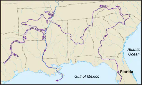
Use the map showing the paths traveled by Hernando de Soto to answer the question.
Did de Soto successfully meet his goals in North America? Why or why not?
No, because he did not discover a sea route between Europe and China.
Yes, because he introduced many people to his Christian faith.
Yes, because he discovered Florida and claimed the land for England.
No, because he did not find any sources of gold or riches.

Use the map to answer the question.
Which of these statements are correct? Select ALL that apply.
Letter X represents the Ohio River.
Letter Y represents the Rio Grande.
Letter Y represents the Mississippi River.
Letter X represents the Hudson River
Letter Z represents the St. Lawrence River.
What did Hernando de Soto accomplish?
He was the first European to cross the Mississippi River.
He was the first European to land in North America.
He was the first European to explore the Rocky Mountains.
He was the first European to locate the Pacific Ocean.

Look at the map of North America. Then answer the question that follows.
Which statements about European explorations of region IV are correct? Select all that apply.
The area was claimed for France.
The area was claimed for Spain.
Christopher Columbus explored the area.
The area was claimed for England.

Use the outline Sasha made while learning about early Europeans in North America to answer the question.
What title should Sasha give her outline?
"Why Europeans Founded the New England Colonies"
"Why American Indians Traded With Europeans"
"Why European Settlers Established Plantations"
"Why Europeans Explored the New World"

Use this map of Florida, created by the Spanish in 1584, to answer the question.
Who could have helped the person making this map the MOST?
Hernando de Soto
Henry Hudson
Jacques Cartier
John Cabot
What were TWO things that caused problems for early European explorers in the Americas?
They often fought with the people who already lived there.
They could not find anyone who was willing to trade with them.
They did not know how to grow food in the new areas.
Their horses and oxen could not survive in the New World.
Their ships were too small to bring their gold back to Europe.

Look at the painting. Then answer the question that follows.
What connection can be made between this painting and European exploration of the New World?
Europeans brought horses to the Americas with them, changing the way some American Indians hunted.
Europeans gave bows and arrows to the American Indians to be used for hunting large animals.
American Indians from different tribes began to hunt with Europeans, building peace between them.
American Indians quickly began to wear European clothing instead of their traditional clothes.
Which region where American Indians lived was heavily forested with plenty of vegetation?
Artic
Southwest
Northwest
Plains
Which region did American Indians tend to live in a dry arid climate?
Southeast
Southwest
Artic
Plains
Which region where the American Indians lived was mostly in a cold, frigid landscape with little vegetation?
Northwest
Southeast
Plains
Artic
In which region did the American Indians depend on the buffalo as a resource?
Northeast
Plains
Southwest
Northwest
Which region did American Indians grow these three main crops..corns, beans, and squash?
Southeast
Plains
Northwest
Southwest
Which region did American Indians build igloos for shelter?
Northeast
Southeast
Plains
Arctic

American Indians in this region used the Pacific Ocean as a source for food like salmon. Which region was it?
Northeast
Northwest
Southeast
Southwest

Which native american tribe lived in region 4?
Northeast
Southeast
Northwest
Southwest

What native american region is identified by 3?
Plains
Southeast
Northwest
Northeast
What is true about all American Indian shelters?
they were teepees made to be moved
they were made of animal skins they hunted
they were made of things found in the environment
they were made from clay known as wattle and daub
In which two regions did American Indians depend on sea animals for part of their diet?
Southwest and Southeast
Northeast and Plains
Northwest and Southwest
Northwest and Arctic
Why did some American Indian cultures develop permanent settlements and others did not?
farming created a reliable food source
they were near the oceans
Europeans made them settle
they got wood from their environment
What is one reason American Indians settled in the Arctic region?
they liked the cold climate
their boats from Europe landed there
to avoid conflict with other American Indian tribes
the land was all they could afford to buy
In which region was farming difficult due to the dry climate causing American Indians to collect rainwater to irrigate (water) their crops?
Southeast
Southwest
Northwest
Northeast
Why did many Plains Indians use teepees for shelter?
there was no grass on the plains to make their shelters of
they had nothing else in their environment to make homes with
they hunted and gathered food and needed shelter that could move
they were not allowed to cut-down trees in the plains to build shelter
Native American art often showed their respect for
nature
food
sleep
movies
How did early groups of American Indians pass their history down to future generations?
They taught American Indian history in schools.
They shared their history through stories and songs.
They published books about their history.
They made time capsules to be opened when they died.
Why did American Indians tell folktales?
(Choose two.)
to entertain neighboring tribes
to teach moral lessons
to learn about European Culture
to explain the occurrence of things in nature
True or False? American Indians today help preserve American Indian cultures of the past through art, powwows, literature, and film.
true
false
American Indians today contribute to the development of modern culture in America through art, literature, film, and dance.
true
false
American Indians today contribute to American life by working, voting, and holding public offices.
true
false
Which shelter did the people in the Arctic region build? This protected them from the hard, cold tundra.
Adobe Pueblo
Igloo
Cedar Plank House
Tepee
Which shelter did the Southwest Native Americans build in the hot desert climate?
Cedar Plank House
Tepee
Chickee
Adobe Pueblo
Which shelter did the Southeast Native Americans build? This kept them dry from flooding.
Igloo
Tepee
Chickee
Wigwam
Which shelter did the Plains Indians build? This was easy to pack up and move when following the buffalo.
Adobe Pueblo
Tepee
Wigwam
Cedar Plank House
What did the Native Americans use for clothes?
tree bark
animal hides
wool from animals
all of the above
How did the first Americans use the land to meet their needs?
Farmed
Hunted
Build Shelter
All of the Above
Which region needed to wear a parka to protect them from the harsh winters?
Southwest
Northwest
Arctic
Plains
Which region used the cedar trees to build huge totem poles to represent their family and culture?
Arctic
Southwest
Northwest
Plains
Which animal helped the Native Americans meet their needs?
Buffalo
Deer
Whale
Fish
All of the Above
How did the Native Americans discover America?
Sailed from Europe
took and airplane
Walked across a land bridge in search of food.
took a train


Which mountain range starts north Georgia?
Chattahoochee River
Rocky Mountains
Pike's Peak
Appalachian Mountains

Which river borders Texas and Mexico?
Rio Grande River
Hudson River
Mississipp River
Ohio River


What is the name of the imaginary line at 0 degrees longitude?
Equator
Prime Meridian
North Pole
South Pole

What important imaginary line of latitude is this shown in red?
Prime Meridian
Equator
International Date Line



Which imaginary lines does this globe show?
The map show the lines of longitude.
The map shows the lines of latitude.

What is this symbol?
scale
key
compass rose
map
Lines of longitude runs from _______ to ________.
north to south
east to west
north to east
south to west

Which river is associated with number 8?
Colorado
Hudson
St. Lawrence
Rio Grande

The Rio Grande River is at number _______.
4
8
5
2

Which mountain range is found along the eastern coast of the United States and is represented by number 6?
Rocky Mountains
Mississippi River
Ohio River
Appalachian Mountain

What separates the Earth into the Northern and Southern Hemispheres?
the equator
lines of latitude
lines of longitude
the Prime Meridian

The Hudson River is at number _____.
4
7
3
5
The Prime Meridian is at 0 degrees ___________
latitude
longitude
equator

The _________ River is at number 3.
Ohio
Mississippi
St. Lawrence
Rio Grande

The Rocky Mountains are located at number _____.
6
7
8
1

Number 5 is the ___________________.
Ohio River
Colorado River
Mississippi River
Hudson River

This river runs at the bottom of the Grand Canyon and is located at number 4.
Rio Grande River
Hudson River
Mississippi River
Colorado River

