
 Worksheets
Semester Exam 25
Total questions: 100
Worksheet time: 1hrs 10mins
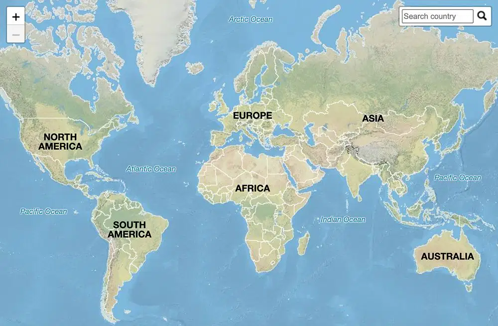
Which is the largest continent?
Africa
Europe
Asia
North America
Which continent is also a country?
Asia
Africa
Australia
Europe
Which continent is south of Europe?
South America
Africa
Asia
Antarctica
Which ocean is west of the Americas?
Atlantic
Indian
Pacific
Arctic
Which continent is entirely in the Southern Hemisphere?
Asia
Antarctica
Europe
North America
The part of a map that shows what symbols mean is called the:
Compass rose
Scale
Legend/key
Grid
A compass rose shows:
Time zones
Directions
Climate
Elevation
What does a map scale show?
Real distance on Earth
Directions
Capital cities
Borders
Lines running north and south on a map are called:
Latitude
Longitude
Lines running east and west on a map are called:
Latitude
Longitude
Prime Meridians
Poles
The 0° latitude line is called:
Prime Meridian
Equator
Tropic of Cancer
Tropic of Capricorn
The 0° longitude line is called the:
Equator
Tropic of Capricorn
Prime Meridian
International Date Line
A physical map shows:
Mountains, rivers, landforms
Population
Countries
Roads
A political map shows:
Landforms
Weather patterns
Borders, states, and countries
Elevation
A thematic map shows:
Only oceans
One specific topic or idea
Highways
Cities only
A map grid helps you:
Measure mountains
Find exact locations
Change elevation
The purpose of a title on a map is to show:
Who created the map
What the map is about
Directions
Coordinates
Latitude measures distance:
North and south of the Equator
East and west of the Equator
From the Prime Meridian
Around the poles
Longitude measures distance:
North and south of the poles
East and west of the Prime Meridian
From the Equator
In miles
What does GPS use to find exact locations?
Satellites
Compasses
Maps
Oceans
A relative location describes:
Exact coordinates
Places near or around the location
Elevation
Population
How many states are in the United States?
48
49
50
52
What is the capital of the United States?
New York
Washington, D.C.
Los Angeles
Chicago
Which country borders the U.S. to the north?
Mexico
Canada
Brazil
Greenland
Which country borders the U.S. to the south?
Canada
Mexico
What is the large mountain range in the eastern United States?
Andes
Rockies
Appalachian Mountains
Alps
Which direction do lines of latitude run?
North–south
East–west
Diagonal
Which direction do lines of longitude run?
East–west
North–south
Diagonal
Horizontal only
A climate map shows:
Landforms
Weather patterns
Roads
Borders
A road map helps you find:
Elevation
Countries
Highways and streets
Climate zones
A population map shows:
People living in certain areas
Mountains
Rivers
Roads
A topographic map shows:
Cities
Elevation and land height
Weather
Countries
Which map would best show rainfall amounts?
Climate map
Road map
Political map
Grid map
Economics is the study of:
Rocks
Money and choices
Laws
Geography
A good is something you:
Do for someone
Can touch or buy
Borrow
Throw away
A service is something you:
Can hold
Provide or do
Eat
Sell only
Scarcity means:
There is unlimited supply
There are not enough resources
Resources never run out
Money is unlimited
Supply means:
What people want
What producers make available
Price of items
What stores buy
Demand means:
How many goods are made
How much people want something
How much it costs to produce
What stores sell
If supply goes up, prices usually:
Go up
Stay the same
Go down
If demand goes up, prices usually:
Go up
Go down
Stop rising
Stay the same
What is a producer?
Someone who buys goods
Someone who makes goods
Someone who repairs goods
Someone who throws away goods
What is a consumer?
Someone who makes products
Someone who sells stock
Someone who buys goods
Someone who regulates business
Which is NOT a factor of production?
Land
Labor
Money
Capital
Land includes:
Human-made tools
Natural resources
Work people do
Business owners
Labor includes:
Tools
Natural resources
People working
Money
Capital includes:
Workers
Machines, tools, buildings
Oil and minerals
Entrepreneurs
Entrepreneurs are people who:
Start businesses and take risks
Work for others
Build roads
Study maps

What State is this
Hawaii
Alaska

What State is this
Alabama
New Mexico
Nevada
Arizona
California

What state is this.
California
Nevada
Arizona
Oregon

What state is this.
Colorado
New Mexico
Utah
Kansas
Nebraska

What state is this.
Connecticut
New Jersy
New York
Rhode island
New Hampshire

What state is this.
Florida
Georgia
Alabama

What state is this.
Georgia
Florida
South Carolina
Alabama

What state is this
Idaho
Washington STATE
Oregon
Nevada
Utah

What State is this.
Maine
Connecticut
New York
New Jersey
New Hampshire

What state is this.
Maryland
Virginia
West Virginia
New York

What state is this.
Michigan
Iowa
Illinois

What state is this.
Montana
Idaho
Colorado
South Dakota
North Dakota

What state is this.
Nevada
Oregon
California
Arizona
Utah

What state is this.
New Hampshire
Maine
Connecticut
New York
New Jersey

What state is this?
North Carolina
Virginia
Tennessee
Georgia
South Carolina

What state is this?
Ohio
Michigan
Indiana
Kentucky
Pennsylvania

What state is this?
Oklahoma
Kansas
New Mexico
Texas
Arkansas

What state is this?
Oregon
Washington
California
Idaho

What state is this?
Pennsylvania
New York
Ohio
Virginia

What state is this?
Rhode Island
Massachusetts
Connecticut

What state is this?
Texas
Oklahoma
New Mexico
Louisiana
Arkansas

What state is this?
Washington
Oregon
Idaho

The location of the red dot is
0°, 120° E
20°S, 120° E
20°N, 20° E

The location of the red dot is
10° N, 80° E
20°N, 80° W
40°S, 20° E

The location of the red dot is
20° N, 80° E
10°N, 80° W
20°S, 120° E

The location of the red dot is
50° N, 60° E
40°N, 40° E
40°S, 60° E

The location of the red dot is
60° N, 50° E
50°N, 120° W
30°S, 100° W

Which dot is the location of 60° N, 40° W
A
B
C

Which dot is the location of 20° S, 80° W
A
B
C

Which dot is the location of 0°, 40° E
A
B
C

Which dot is the location of 30° N, 20° W
A
B
C

Which dot is the location of 30° S, 100° W
A
B
C

The RED line is the
Prime Meridian
Equator

The BLUE line is the
Prime Meridian
Equator

Lines of longitude are shown on the map in BLUE. Lines of longitude measure
how far a location is north or south of the Equator.
how far a location is east or west of the Prime Meridian

I am a Caribbean nation.
I am located west of the Dominican Republic but east of Jamaica.
I am located not far from Florida to the southeast.
What am I?
Cuba
Bahamas
Mexico
Haiti
All types of businesses that are related to the same good or service
industry
friends
category

Traders using the Silk Route had to overcome the physical barriers posed by the mountains and the —
Great Wall of China
Numerous river crossings
threat of natural disasters
desert climate conditions

According to the map, what Russian city is located at 60° N latitude/ 30° E longitude?
Moscow
Novgorod
Rostov
St. Petersburg

At which geographic location will you find most Russian cities?
Between 60°N and 45°N latitude and 60°E and 75°E longitude
Between 45°N and 60°N latitude and 30°E and 60°E longitude
Between 60°N and 75°N latitude and 30°E and 60°E longitude
Between 45°N and 60°N latitude and 75°E and 90°E longitude

Which of the following questions can be answered by this map?
In what general location is most of the manufacturing located in the United States?
Why is Hawaii a series of islands in the Pacific Ocean?
In what kind of soil does commercial farming work best?
How is trade accomplished between Canada and the United States?

Which of the following inferences can be made from the map?
Russia has no access to water
St. Petersburg is the capital of Russia
More people probably live in Eastern Russia
Siberia's Northern location can make for very cold winters

Look at the graph above. Which of the following statements is true about
the month of August?
There are about 6 inches of rain with a temperature of about 80 degrees.
There are about 6 inches of rain with a temperature of about 50 degrees.
There are about 8 inches of rain with a temperature of about 60 degrees.
There are about 8 inches of rain with a temperature of about 50 degrees.

Which of the following is a term used for a mapmaker?
Biographer
cartographer
oceanographer
mapographer

Both Perth and Brisbane are population centers in Australia. What do the two locations have in common?
They are both located on the Pacific Ocean
They are both located on the Indian Ocean
They are both located near 115 degrees east
They are both located close to latitude 30 degrees south

Upon examining current satellite images of various ancient monuments in a region, a student of geography could answer which one of the following questions?
How was it created?
Who were the builders?
How has this place changed over time?
What is significant about its location?

Geographers would use a grid system on maps to
reveal patterns of migration
determine elevation
determine the position of a location
predict weather
Professional geographers pose specific questions when studying features of Earth. One important geographic question is “What is significant about its location?”
One likely way geographers answer the question above is by -
tracking changes of the moon and stars
studying the history and economy of a local culture
investigating possible treatments for a medical illness
debating government officials about new environmental policies

Professional geographers pose specific questions when studying features of Earth. One important geographic question is “Where is it located?”
One likely way geographers answer the question above is by —
interviewing members of remote tribes
excavating artifacts left by previous societies
predicting the weather with computer models
using an intersection of longitude and latitude

Which physical geographic region is located at 0° latitude and 60°W longitude?
Equator in South America
High latitudes in North America
Equator in Africa
Middle latitudes in Europe

Which set of coordinates is the absolute location of H?
15°S, 100°W
15°S, 75°E
45°S, 75°W
15°N, 100°W

What is the relative location of B from D?
southwest
southeast
northwest
northeast

