
 Worksheets
Geo review
Total questions: 47
Worksheet time: 24mins
All of the following are critical determiners of climate except-
A. elevation
B. latitude
C. proximity to water
D. amount of rainfall
To find relative location, first find-
latitude lines
a map projection
longitude lines
a reference point
Which of the following is a key characteristic of an arid (desert) climate region?
found near the north and south poles
mostly includes rain forest areas
receives less than 10 inches of rainfall per year
receives more than 80 inches of rainfall per year
Why don't all places on Earth receive the same amount of direct sunlight at the same level?
the earth's axis is tilted
the earth receives sunlight in an unpredictable pattern
weather in places changes over time
the earth rotates from east to west
A map that shows national and state boundaries, as well as cities is called a-
population density map
political map
physical map
climate map
What is a large ocean wave that results from an underwater earthquake, landslide, or volcanic eruptions?
seismic gap
tsunami
aftershock
derecho
Why would people in La Porte, Texas be concerned about hurricanes?
Texas has a high elevation
the city is located along fault lines
the city is located on the Gulf Coast
northerly winds
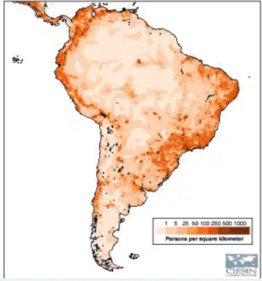
Based on the image, where is the highest population density in South America?
the Southern part of the continent
near the interior of the continent
along the coast
along the rivers
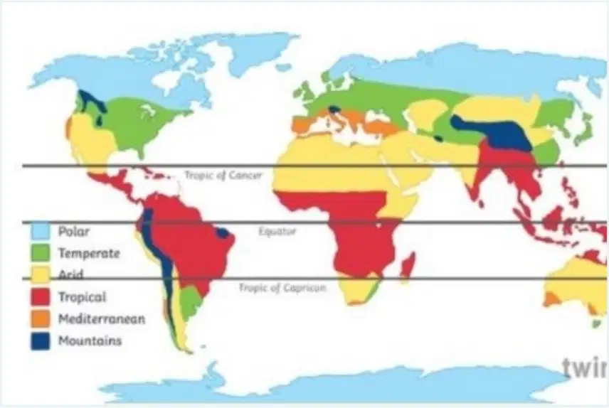
Based on the map, what climate type is predominantly found in the low latitudes?
polar
tropical
temperate
arid
Which two hazards usually occur along plate boundaries? Correctly click on the picture(s). Choose TWO answers.
Hurricane
Earthquakes
Volcanoes
Monsoons
Tsunami
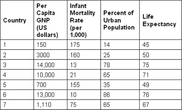
Which of the above countries would be considered highly developed?
F. 2, 3, 7
G. 2, 3, 4
H. 3, 4, 6
J. 3, 6, 7
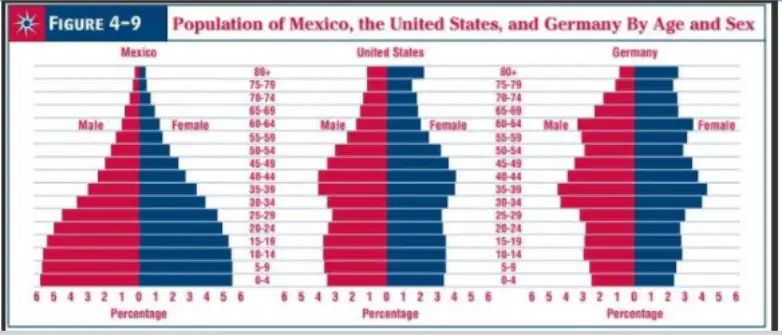
Based on the data in the population pyramids above, which of the following statements is true?
A. Mexico is experiencing rapid growth
B. Men live longer than women in the United States
C. Germany is experiencing rapid growth
D. The United States population is doubling each year
In a market economy-
the production and price of goods are determined by supply and demand
the central government runs the economy according to a strict plan to ensure efficient production
the price and quantity of goods are based on longstanding customs and traditions
economic decisions are made collectively by groups of people for the good of the community
Which THREE religions share a belief in only one god?
Christianity
Hinduism
Judaism
Buddhism
Islam
Which TWO factors contributed most to wildfires in the west?
drought
dropping temperatures
elevation
increased warming
storm surges
Which of the following are effects of a warming Arctic Ocean? Choose THREE answers.
change in climate and precipitation patterns
increase in fish stocks and birds
rising sea level
increasing severe weather events
increase in marine animals
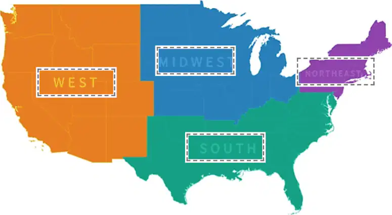
Which U.S region does not border an ocean? Correctly identify the region on the map.
West
Midwest
South
Northeast
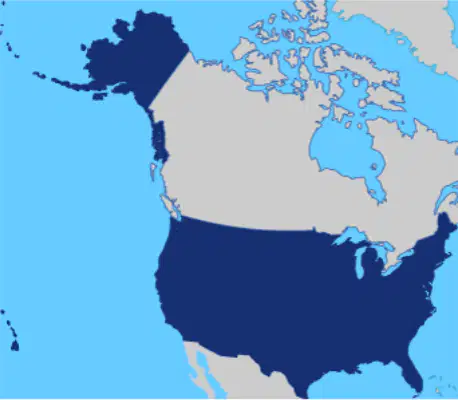
Which state is not part of the continental North America?
Alaska
Hawaii
Texas
Michigan
Which THREE Asian countries have the largest number of immigrants in the U.S. today?
Japan
India
China
North Korea
Philippines
How would you describe the USMCA?
An updated version of NAFTA
an updated version of NAFTA that terribly affects the United States
75% of the parts for a vehicle must be sourced from North America to be tariff free
A version of NAFTA that makes the economy suffer
New laws that protect intellectual property, the internet and investments
Instead of using the term "states", which terms are used to identify the land divisions in Canada?
federal districts and cities
provinces and territories
capital and provinces
cities and territories
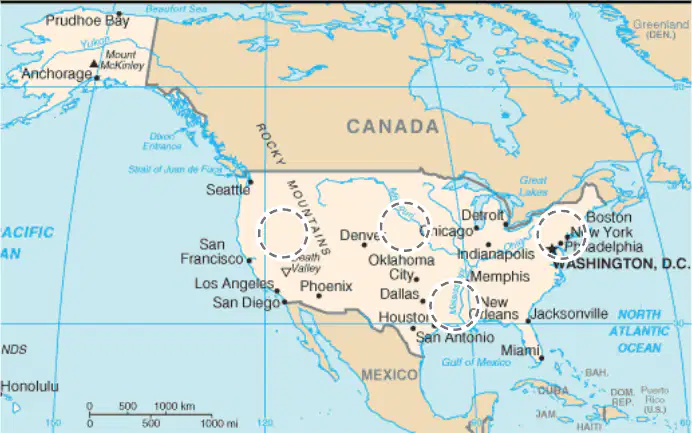
Which region in the United States is heavily populated? Correctly click on the location on the map.
Northeast
Midwest
Mountain West
Great Plains
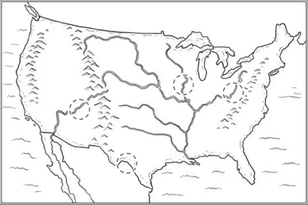
Correctly identify the river that divides the United States from Mexico.
Mississippi River
Colorado River
Rio Grande
Missouri River
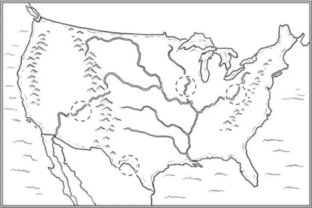
There are two prominent mountain ranges found in North America. Which of the following pairs correctly identifies them?
Rocky Mountains and Appalachian Mountains
Andes Mountains and Sierra Nevada
Himalayas and Alps
Ural Mountains and Pyrenees
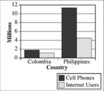
Refer to the graph titled 'Number of Cell Phones and Internet Users for Two Countries.' Which inference is best supported by the data in the graph?
The Philippines and Columbia are located in similar regions of the world.
The Philippines and Columbia have very similar communication systems.
The economy and infrastructure of the Philippines are probably more advanced than Colombia's.
The Columbian economy is probably suffering from border conflicts with its neighbors.
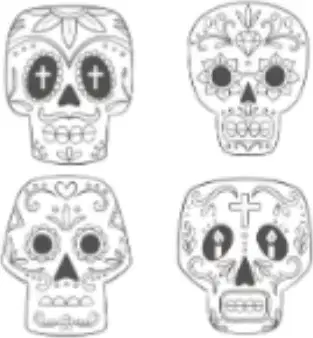
Correctly title the picture below by identifying what event it is celebrating.
Dia de los Muertos
Mexican Independence
Harvest Season
Halloween
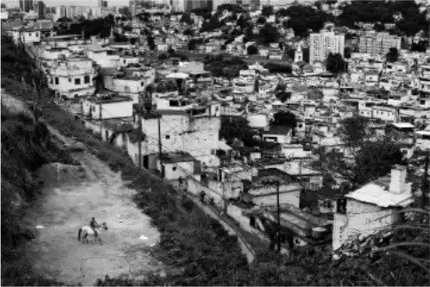
What is the term for the slums of Rio de Janeiro?
Maquiladoras
Favelas
Haciendas
Lojas
Latin America and the Caribbean are very diverse, culturally blended areas. One reason this diversity is the
F. conquest of Aztecs by the Mayans
G. Migration of ancient people from Asia
H. importation of indentured servants from Ireland
J. intermarriage of European settlers and indigenous people
Which of the following correctly list a positive economic and a negative geographic impact of deforestation in the Amazon basin?
A. Logging and its byproducts create thousands of jobs, and indigenous people who live in these areas can take those jobs
B. There is a possibility that thousands of cures can be found in the forest, and erosion from logging is destroying the soil
C. Cities and transportation systems are growing throughout the region, and more medical and health care is available
D. More land is available for agriculture and ranching, and there is a loss of land in natural habitats
Why is a location on the ocean often a good place for a new settlement?
It provides water and natural resources as well as transportation opportunities
It is a safer location for a settlement
It is a location with a high elevation
It is not susceptible to harsh weather
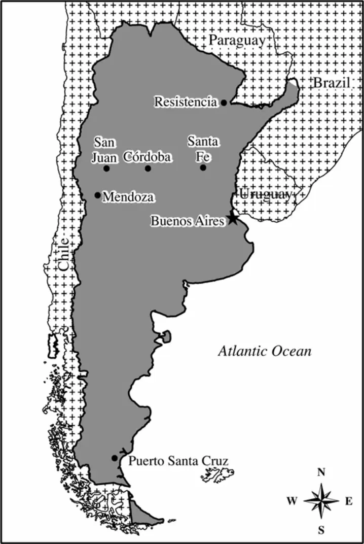
The map above shows that Argentina's largest cities are located MOSTLY —
A. along the Atlantic coast
B. in the southern half of the country
Which physical feature is a natural border between Argentina and Chile?
deserts
rivers
plains
mountains
Which early 1900s construction project of the United States has served as a center of urbanization, transportation, and economic activities in Central America?
Port-au-Prince in Haiti
Panama Canal in Panama City
Bridge of the Americas in El Salvador
Pan-American Highway
mountains are found in Mexico
Sierra Madre
mountains are found in South America.

The Panama Canal created a shortcut between the
What impact did the Ring of Fire have on Chile?
narrow strip of land that connects two larger landmasses with bodies of water on both sides
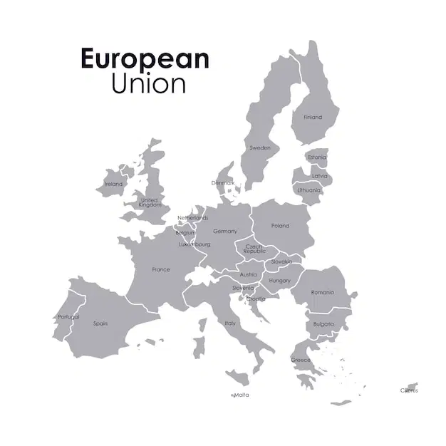
what is the map showing?
European Union
Mediterranean climate most likely experience
warm, dry summers
hot, wet winters.
Hot, humid summers
Under the EU, a common currency was created to promote growth, stability, and economic integration in Europe. What was the name chosen for this currency?
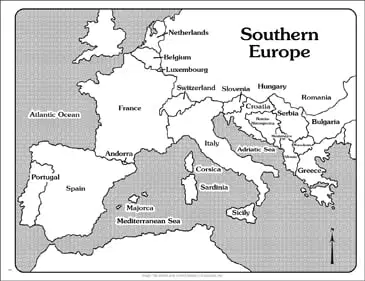
Which two bodies of water are important to the economic development of Southern Europe
Mediterranean Sea, Atlantic Ocean
was a pull factor that led to many immigrants to European nations in recent decades.
How does the climate change as you move from the equator to higher latitudes?
The climate becomes colder

Using the map below, why does the Gulf Stream make climates in the same latitudes warmer in Europe than in Canada?
The Gulf Stream brings warmer water currents.

Imaginary line that separates the Eastern and Western Hemispheres.

Imaginary line that runs east to west around the world.

