
Font size
 Worksheets
Geography Quiz— Grade 11
Total questions: 131
Worksheet time: 1hrs 6mins
Who among the following said that Geography is a concern with description and explanation of the areal differentiation of the Earth’s surface
Herodotus
Eratosthenes
Richard Hartshorne
Galileo
Which one of the following is not a natural science
Pedology
Botany
Geology
Sociology
The regional approach was developed by
Alexander Von Humboldt
Karl Ritter
Ptolemy
Ibn-E-Batuta
When did the Big Bang event take place
13.6 Million Years Ago
13.7 Million Years Ago
4.6 Million Years Ago
4.6 Billion Years Ago
The Crust and Mantle are separated by which of the following discontinuities
Gutenberg Discontinuity
Moho Discontinuity
Conrad Discontinuity
Lehman Discontinuity
What is the main source of magma inside the earth’s surface
Core
Crust
Asthenosphere
Magnetosphere
Which of the following layer is known as NiFe
Mantle
Continental crust
Oceanic crust
Core
The age of the Deccan trap of India is
10 million years
1 billion years
20 million years
60 million years
Which of the following is the youngest physical feature among the given options
Himalayas
Indian peninsula
Deccan traps
Pangaea
Indian plate and Antarctica plate forms which of the following type of boundaries
Convergent boundary
Divergent boundary
Transform boundary
Fault zone
_____ is the science of rocks.
Pedology
Petrology
Pedagogy
Numerology
Which of the following is essential for the formation of sedimentary rocks
Differentiation
Solifluction
Lithification
degassing
Arrangement of minerals or materials of different groups, into alternating thin or thick layers appearing in light and dark shades is called
foliation
lineation
banding
lithification
Rocks which are the result of deposition of fragments of rocks by exogenous rocks
Igneous rocks
Sedimentary rocks
Metamorphic rocks
All of them
Which country among India’s neighbours share longest land boundary
Nepal
Bangladesh
Bhutan
Pakisthan
Which of the following states is not included in the Seven Sisters
Mizoram
Tripura
Nagaland
Sikkim
From Arunachal Pradesh to Gujarat there is a time lag of
24 hours
12 hours
2 hours
30 minutes
Due to which of the following reasons is the Indian Ocean named after India
India has a strategic location along the trans-Indian Ocean routes
No other country has a long coastline on the Indian Ocean as India
India is centrally located at the head of the Indian Ocean
All the above
Which one of the following forms the southern-most tip of the Indian mainland
Indira Point
Kanyakumari
Palk Strait
Kavaratti
A relief which divides two areas drained by the river system is known as
Water divide
River basin
Drainage pattern
Water management
The Ganga has its minimum flow during
August-September
January-June
May-June
July-August
In the final stage before meeting the seas and oceans, river breakup into various streams called as
Tributaries
Deltas
Estuaries
Distributaries
The flow of water through well-defined channels is called
Catchment area
Sewage
Flowage
Drainage
What is the pattern in which the river and its tributaries flow in a manner similar to trees
Dendritic pattern
Radial pattern
Centripetal pattern
Trellis pattern
Who among the following said that Geography is a concern with description and explanation of the areal differentiation of the Earth’s surface.
Herodotus
Eratosthenes
Hettner
Richard Hartshorne
Identify the correct sequence of stages of formation of planets: [i] Small rounded objects developed by the process of cohesion are called planetesimals. [ii] The gravitational force within a nebula leads to formation of core of gas and dust. [iii] Large number of small planetesimals accrete to form fewer large bodies in the form of planets. Choose the correct option.
i, ii, iii
ii, i, iii
iii, i, ii
iii, ii, i
Debris avalanche can be included in the category of:
Landslides
Slow flow mass movements
Rapid flow mass movements
Subsidence
Assertion (A) Thickness of the troposphere is lowest at the equator. Reason (R) At the equator heat is transported at great heights by strong convectional current. Choose the correct option.
A and R are true and R is the correct explanation of A
A and R true but R is not the correct explanation of A
A is false but R is true
A is true but R is false
Which of the following is termed as the normal lapse rate.
The rate of increase of temperature with height
The rate of decrease of temperature with height
The rate of increase of temperature with weight
None of the above
Which of the following pair is not matched correctly.
Insolation – Incoming solar radiation
Albedo – The percentage of visible light reflected by an object
Isotherm – The lines joining the places of equal rainfall
Annual range – The difference between the mean temperature of the warmest and coldest months
Koeppen’s system of classification of climates can be termed as:
Applied
Systematic
Genetic
Empirical
Based on the facts I. Bring cold water into warm area. II. Usually found in the west coast of the continent in the low latitude. III. Also found in the east coast of the continent in the high latitude. Find the characteristic feature of which of these.
Warm ocean current
Cold ocean current
Diurnal tide
Mixed tide
Arrange the following capital towns in a sequence order according to their direction from west to east: (i) Bhopal (ii) Shillong (iii) Jaipur (iv) Ranchi. Choose the correct option.
iii, i, iv, ii
iv, i, iii, ii
ii, iii, iv, i
iii, iv, i, ii
Assertion (A) The distance between two longitudes does not remain the same everywhere. Reason (R) Longitudes are joined at the poles. Choose the correct option.
Both A and R are true and R is the correct explanation of A
Both A and R are true but R is not the correct explanation of A
A is false but R is true
A is true but R is false
Match the following – SL NO 1 Alaknanda with Kali; 2 Alaknanda with Dhauli; 3 Alaknanda with Pindar; 4 Alaknanda with Bhagirathi; PRAYAG options A KarnaPrayag, B DevPrayag, C RudraPrayag, D Vishnu Prayag. Choose the correct option.
1A, 2B, 3C, 4D
1D, 2C, 3B, 4A
1B, 2A, 3D, 4C
1C, 2D, 3A, 4B
Which one of the following phenomenon happens when the sun shines vertically over the Tropic of Cancer in the northern hemisphere.
High pressure develops over North‑western India due to low temperature
Low pressure develops over North‑western India due to high temperature
No changes in temperature and pressure in North‑western India
North‑western cyclonic disturbances occur in the North‑western part of India
Trees like rosewood, ebony and mahogany are found in which of the following forest.
Montane forests
Tropical deciduous forests
Tropical evergreen and semi‑evergreen forests
Tropical thorn forests
Which of the following states are among the high flood prone states of India.
Assam, Maharashtra and Himachal Pradesh
Bihar, Uttar Pradesh and Punjab
West Bengal, Haryana and Sikkim
Assam, West Bengal and Bihar
Assertion – The planet earth initially was a barren, rocky and hot object with a thin atmosphere of hydrogen and helium. Reason – The period, between the 4,600 million years and the present, led to the evolution of life on the surface of the planet. Choose the correct option.
Both Assertion and Reason are correct and Reason is the correct explanation for Assertion
Both Assertion and Reason are correct but Reason is not the correct explanation for Assertion
Only Assertion is correct
Only Reason is correct
Statement I – Mass movements transfer the mass of rock debris down the slopes under the direct influence of gravity. Statement II – Mass movements are very active over weathered slopes rather than over unweathered materials. Choose the correct option.
Only Statement I is correct
Only Statement II is correct
Both statements are correct
Both statements are incorrect
Assertion – Very deep and wide meanders can also be found cut in hard rocks. Reason – Such meanders are called incised or entrenched. Choose the correct option.
Both Assertion and Reason are correct and Reason is the correct explanation for Assertion
Both Assertion and Reason are correct but Reason is not the correct explanation for Assertion
Only Assertion is correct
Only Reason is correct
A deep, long and wide trough or basin with very steep concave high walls at its head as well as in sides is known as
Cirque
Lateral Moraine
Glacial valley
Esker
The mesopause lies between ----------- & ----------- which extends up to a height of 80 km.
The troposphere and the stratosphere
The stratosphere and the mesosphere
The ionosphere and the exosphere
The mesosphere and the thermosphere
The Earth after being heated itself becomes a radiating body and it radiates energy to the atmosphere in long wave form. This energy heats up the atmosphere from below. This process is known as
Solar radiation
Terrestrial radiation
Insolation
Inversion of temperature

Match the column I item Continental Shelf with the appropriate description from column II.
covered with fine-grained sediments like clay and silt
an average gradient of 1° or even less
are relatively steep sided, narrow basins
The depth of this region varies between 200 and 3,000 m

Match the column I item Continental Slope with the appropriate description from column II.
covered with fine-grained sediments like clay and silt
an average gradient of 1° or even less
are relatively steep sided, narrow basins
The depth of this region varies between 200 and 3,000 m

Match the column I item Deep Sea Plain with the appropriate description from column II.
covered with fine-grained sediments like clay and silt
an average gradient of 1° or even less
are relatively steep sided, narrow basins
The depth of this region varies between 200 and 3,000 m

Match the column I item Oceanic Deeps or Trenches with the appropriate description from column II.
covered with fine-grained sediments like clay and silt
an average gradient of 1° or even less
are relatively steep sided, narrow basins
The depth of this region varies between 200 and 3,000 m
Which one of the following is the highest cloud in the sky?
Cirrus
Nimbus
Stratus
Cumulus
Assertion: The actual distance of India measured from north to south extremity is 3,214 km, and that from east to west is only 2,933 km. Reason: This difference is based on the fact that the distance between two longitudes decreases towards the poles.
Both Assertion and Reason are correct and Reason is the correct explanation for Assertion
Both Assertion and Reason are correct but Reason is not the correct explanation for Assertion
Only Assertion is correct
Only Reason is correct
Indian Standard Time is ahead of Greenwich Mean Time by
5 hours
5 hours 20 minutes
5 hours 30 minutes
none of these
On which of the following hill range is the Dodabeta peak situated?
Nilgiri hills
Cardamom hills
Anaimalai hills
Nallamala hills
Which of the following is not included in central highlands?
Satpura ranges
Vindhyan ranges
Kaimur ranges
Mahendragiri ranges
When the streams flow in different directions from a central peak or dome-like structure, a ______ pattern is developed.
Dendritic
Radial
Centripetal
Trellis
The pattern of flow of water in a river channel over a year is known as what?
Regime
Cumecs
Cusecs
None of these
Assertion: Most of the major Peninsular rivers except Narmada and Tapi flow from west to east. Reason: The Shetruniji is one such river which rises near Dalkahwa in Amreli district and flows towards east.
Both Assertion and Reason are correct and Reason is the correct explanation for Assertion
Both Assertion and Reason are correct but Reason is not the correct explanation for Assertion
A is correct; R is not correct
A is false; R is true
Statement I: The physiography or relief of India also affects the temperature, air pressure, direction and speed of wind and the amount and distribution of rainfall. Statement II: The windward sides of Western Ghats and Assam receive high rainfall.
Only statement I is correct
Only statement II is correct
Both statements are correct
Both statements are incorrect
Tidal and deltaic forests are found in which region of India?
Eastern Coast
Western Coast
Rann of Kachchh
Bay of Mannar
Which one of the following figures represents the age of the earth?
4.6 million years
13.7 million years
4.6 billion years
13.7 trillion years
Which of the following processes are gradational processes?
Deposition
Volcanism
Diastrophism
Erosion
Karst topography is prominent in which rocks?
Limestone
Rocks rich in magnesium
Dolomite
Both (A) and (B)
Assertion (A) The work of groundwater can not be seen in all types of rocks. Reason (R) Physical or mechanical removal of materials by moving groundwater is insignificant in developing landforms. Codes:
Both A and R are true and R is the correct explanation of A
Both A and R are true, but R is not the correct explanation of A
A is true, but R is false
A is false, but R is true
Which of the following gases is largely responsible for the greenhouse effect?
Oxygen
CO2
Xenon
Krypton
The energy received by the Earth is known as ….
Incoming solar radiation
Outgoing solar radiation
Scattering
Reflected energy
Coriolis force is the result of
Gravitational pull of the Earth
Gravitational pull of the Moon
Rotation of the Earth
Revolution period of the Earth
Assertion (A) There is huge water crisis in different parts of the world. Reason (R) The renewable water on the Earth is constant while the demand is increasing tremendously. Codes:
Both A and R are true and R is the correct explanation of A
Both A and R are true, but R is not the correct explanation of A
A is true, but R is false
A is false, but R is true
Which one of the following countries shares the longest land frontier with India?
Bangladesh
China
Pakistan
Myanmar
Which of the following countries is included in the Indian subcontinent?
Pakistan
Nepal
Bhutan
All of these
On which of the following hill range is ‘Dodabeta’ peak situated?
Nilgiri hills
Anaimalai hills
Cardamom hills
Nallamala hills
Which of the following are the East flowing rivers of the Peninsula block?
Mahanadi
Krishna
Kaveri
All of these
Which one of the following rivers was known as the ‘Sorrow of Bengal’?
The Gandak
The Son
The Kosi
The Damodar
Which of the following rivers is known as Singi khamban in Tibetan range?
Indus
Brahmaputra
Satluj
Kosi
Assertion (A) Narmada and Tapi flow in rift valley. Reason (B) Narmada and Tapi drain in the Bay of Bengal. Codes:
Both A and R are true and R is the correct explanation of A
Both A and R are true, but R is not the correct explanation of A
A is true, but R is false
A is false, but R is true
Which of the following region receive rainfall in winter season from North-East monsoon?
Punjab
Western Uttar Pradesh
Southern Andhra Pradesh
Goa
How many of the Biosphere reserves from India are recognised by the UNESCO?
one
two
eight
eleven
Assertion (A) The universe is expanding. Reason (R) As time passes galaxies move further and further apart. Choose the correct option:
A and R are true and R is the correct explanation of A.
A and R true but R is not the correct explanation of A.
A is true but R is false.
A is false but R is true.
Identify the correct sequence of stages of formation of planet. [i] Small rounded objects developed by the process of cohesion are called planetesimals. [ii] Large number of small planetesimals accrete to form fewer large bodies in the form of planets. [iii] The gravitational force within a nebula leads to formation of core of gas and dust. Choose the correct option:
i, ii, iii
ii, i, iii
iii, i, ii
iii, ii, i
Debris avalanche can be included in the category of:
Weathering
Mass wasting
Erosion by running water
Aeolian processes
Arrange the correct sequence of Column II (Landform) against Column I (Agent) and choose the correct option: Column I: I. Wind, II. Underground water, III. Running water, IV. Sea Waves. Column II: 1. Rapids, 2. Cliff, 3. Sand dunes, 4. Stalagmite. Options show complete sequences for I–IV mapped to 1–4.
I-3, II-4, III-1, IV-2
I-3, II-1, III-4, I-2
I-2, II-1, III-3, IV-4
I-1, II-2, III-3, IV-4
Which of the following pair is not matched correctly? a) Insolation – Incoming solar radiation b) Albedo – The percentage of visible light reflected by an object c) Isotherm – The lines joining the places of equal rainfall d) Annual range – The difference between the mean temperature of the warmest and coldest months.
a) Insolation – Incoming solar radiation
b) Albedo – The percentage of visible light reflected by an object
c) Isotherm – The lines joining the places of equal rainfall
d) Annual range – The difference between the mean temperature of the warmest and coldest months
Assertion (A): India has 2 hours time difference between the easternmost and westernmost part of the country. Reason (R): Latitudinal variation in India is nearly 30 degrees. Choose the correct option.
Both A and R are true and R is the correct explanation of A
Both A and R are true but R is not the correct explanation of A
A is false but R is true
A is true but R is false
Arrange the following capital towns in sequence order according to their direction from east to west: (i) Jaisalmer (ii) Guwahati (iii) Bhubaneswar (iv) Bangaluru (v) Raipur. Choose the correct option from the sequences provided.
i, iv, iii, ii, v
iv, i, iii, v, ii
ii, iii, iv, i, v
ii, iii, v, iv, i
What is the total length of the Indian coastline?
6100 km
7517 km
7157 km
5717 km
Saddle Peak is situated in which part of Andaman & Nicobar Islands?
North Andaman
Middle Andaman
South Andaman
Great Nicobar
Consider the following and choose the correct answer with the help of given codes: Peaks — I. Mahendragiri, II. Anaimudi, III. Kanchenjunga, IV. Saddle. Hill regions — A. Eastern Ghats, B. North Andaman, C. Himalayas, D. Western Ghats. Select the correct sequence for I–IV.
A B C D
A D C B
D A C B
C D A B
Consider the following and choose the correct answer with the help of given codes: Rivers — I. Alaknanda & Kali, II. Alaknanda & Dhauli, III. Alaknanda & Pindar, IV. Alaknanda & Bhagirathi. Prayag — A. KarnaPrayag, B. DevPrayag, C. RudraPrayag, D. Vishnu Prayag. Select the correct sequence for I–IV.
A B C D
D C B A
D A C B
C D A B
In which of the following states is Loktak Lake situated?
Meghalaya
Manipur
Uttarakhand
Kerala
Which of the following rivers is known as the sorrow of Bihar?
Narmada
Damodar
Kosi
Chambal
Which one of the following phenomena happens when the sun shines vertically over the Tropic of Capricorn in the southern hemisphere?
High pressure develops over North-western India due to low temperature
Low pressure develops over North-western India due to high temperature
No changes in temperature and pressure in North-western India
North-western cyclonic disturbances occur in the North-western part of India
Assertion (A): The planet Earth initially was a barren, rocky and hot object with a thin atmosphere of hydrogen and helium. Reason (R): The period between 4,600 million years ago and the present led to the evolution of life on the surface of the planet. Choose the correct option.
Both (A) and (R) are true, and (R) is the correct explanation of (A)
Both (A) and (R) are true, and (R) is not the correct explanation of (A)
(A) is true, but (R) is false
(A) is false, but (R) is true
Which type of endogenic process is responsible for intense compressional forces leading to mountain building along elongated and narrow belts of the Earth’s crust?
Erosional processes
Volcanic processes
Orogenic processes
Epeirogenic processes
Which process of atmospheric heating involves the horizontal transfer of heat by the movement of air from one region to another?
Conduction
Convection
Advection
Radiation
Consider the following statements regarding the Coriolis Effect: 1. It causes moving air to be deflected to the right in the Northern Hemisphere. 2. It is strongest at the poles and weakest (almost zero) at the Equator. 3. It influences the direction of global wind systems and ocean currents. Which of the statements given above are correct?
1 and 2 only
2 and 3 only
1 and 3 only
1, 2, and 3
What is the term used to describe the rapid decrease in ocean temperature with depth?
Halocline
Thermocline
Pycnocline
Isocline
Which one of the following latitude mark the northern extent of India’s area?
8∘4′N
35∘7′N
6∘45′N
37∘6′N
Which one of the following countries shares the shortest land frontier with India?
Bangladesh
China
Bhutan
Pakistan
Which is the highest mountain peak of Western ghat?
Anaimudi
Dodabeta
Mahendragiri
Malayagiri
Which of the following is Not included in central highlands?
Satpura ranges
Vindhyan ranges
Zaskar range
Kaimur ranges
Consider the following statement: Statement I: The drainage pattern of a region is largely controlled by its geological structure and relief. Statement II: The rivers of the Himalayan region are perennial in nature as they are fed by both rainfall and snowmelt. Which of the statements given above is/are correct?
Only statement I is correct
Only statement II is correct
Both statements are correct
Both statements are incorrect
Match the river and its tributary: Ganga — choose the correct tributary from Tungabhadra, Son, Indravati, Chambal.
Tungabhadra
Son
Indravati
Chambal
Match the river and its tributary: Godavari — choose the correct tributary from Tungabhadra, Son, Indravati, Chambal.
Tungabhadra
Son
Indravati
Chambal
Match the river and its tributary: Krishna — choose the correct tributary from Tungabhadra, Son, Indravati, Chambal.
Tungabhadra
Son
Indravati
Chambal
Match the river and its tributary: Yamuna — choose the correct tributary from Tungabhadra, Son, Indravati, Chambal.
Tungabhadra
Son
Indravati
Chambal

Observe the diagram of streams radiating outward from a central high point with arrows indicating flow direction and answer the question: The drainage pattern shown in the diagram is known as:
Dendritic drainage pattern
Trellis drainage pattern
Radial drainage pattern
Rectangular drainage pattern
Which one of the following was the main objective of Project Tiger?
To eliminate tigers from forest areas
To promote wildlife documentary films
To keep tigers only in zoological parks
To conserve tigers and protect them from illegal hunting
Who proposed the Nebular Hypothesis in its early form?
Immanuel Kant
Albert Einstein
Galileo Galilei
Charles Darwin
Processes involving mountain building through severe folding and affecting long and narrow belts of the earth’s crust are called:
Erosional
Orogenic
Epeirogeny
Volcanic
Which one of the following is NOT an erosional landform?
Cirque
Alluvial Fans
Mushroom rock
U-shaped valley
Match the landform with its agent of formation: Cirque — choose the correct agent from Wind, Glacier, River, Running Water.
Wind
Glacier
River
Running Water
Match the landform with its agent of formation: Sand dunes — choose the correct agent from Wind, Glacier, River, Running Water.
Wind
Glacier
River
Running Water
Match the landform with its agent of formation: Meander — choose the correct agent from Wind, Glacier, River, Running Water.
Wind
Glacier
River
Running Water
Match the landform with its agent of formation: Delta — choose the correct agent from Wind, Glacier, River, Running Water.
Wind
Glacier
River
Running Water
regulating Earth's temperature?
Oxygen
Nitrogen
Carbon dioxide
Argon
Assertion (A): The Earth receives only a small portion of the Sun’s energy. Reason (R): Most of the Sun’s radiation is either absorbed or scattered in space before reaching Earth. Choose the correct option:
Both A and R are true, and R is the correct explanation of A.
Both A and R are true, but R is not the correct explanation of A.
A is true, but R is false.
A is false, but R is true.
Consider the following statements regarding the Coriolis Effect: 1. It causes moving air to be deflected to the right in the Northern Hemisphere. 2. It is strongest at the Equator and weakest at the poles. 3. It influences the direction of global wind systems and ocean currents. Which of the statements given above are correct?
1 and 2 only
2 and 3 only
1 and 3 only
1, 2, and 3
Salinity is the term used to define the total content of dissolved salts in sea water. It is calculated as the amount of salt (in gm) dissolved in _______ of seawater.
100 gm
10 gm
500 gm
1000 gm
What is the significance of the Indian Standard Meridian (82°30′E)?
It passes exactly through the centre of India.
It helps in uniform timekeeping across the country.
It is the natural boundary between northern and southern India.
It determines the summer and winter solstices in India.
Which neighbouring country of India shares the longest land border?
China
Nepal
Pakistan
Bangladesh
Assertion (A): The Peninsular Plateau is considered the oldest landmass of India. Reason (R): It was part of the ancient Gondwana land. Choose the correct option:
Both A and R are true, and R is the correct explanation of A.
Both A and R are true, but R is not the correct explanation of A.
A is true, but R is false.

Match the physiographic divisions with their features: Physiographic Division — a) Northern Mountains, b) Peninsular Plateau, c) Coastal Plains, d) Islands; Feature — 1) Young fold mountains, 2) Igneous and metamorphic rocks, 3) Narrow and level land, 4) Volcanic origin (Andaman & Nicobar). Which feature correctly matches Northern Mountains?
Young fold mountains
Igneous and metamorphic rocks
Narrow and level land
Volcanic origin (Andaman & Nicobar)

Match the physiographic divisions with their features: Physiographic Division — a) Northern Mountains, b) Peninsular Plateau, c) Coastal Plains, d) Islands; Feature — 1) Young fold mountains, 2) Igneous and metamorphic rocks, 3) Narrow and level land, 4) Volcanic origin (Andaman & Nicobar). Which feature correctly matches Peninsular Plateau?
Young fold mountains
Igneous and metamorphic rocks
Narrow and level land
Volcanic origin (Andaman & Nicobar)

Match the physiographic divisions with their features: Physiographic Division — a) Northern Mountains, b) Peninsular Plateau, c) Coastal Plains, d) Islands; Feature — 1) Young fold mountains, 2) Igneous and metamorphic rocks, 3) Narrow and level land, 4) Volcanic origin (Andaman & Nicobar). Which feature correctly matches Coastal Plains?
Young fold mountains
Igneous and metamorphic rocks
Narrow and level land
Volcanic origin (Andaman & Nicobar)

Match the physiographic divisions with their features: Physiographic Division — a) Northern Mountains, b) Peninsular Plateau, c) Coastal Plains, d) Islands; Feature — 1) Young fold mountains, 2) Igneous and metamorphic rocks, 3) Narrow and level land, 4) Volcanic origin (Andaman & Nicobar). Which feature correctly matches Islands?
Young fold mountains
Igneous and metamorphic rocks
Narrow and level land
Volcanic origin (Andaman & Nicobar)
Which river is considered the largest west-flowing river in India?
Narmada
Tapi
Sabarmati
Krishna
If a region experiences heavy rainfall and high runoff, which type of river basin is most likely to develop?
Dendritic
Trellis
Radial
Rectangular
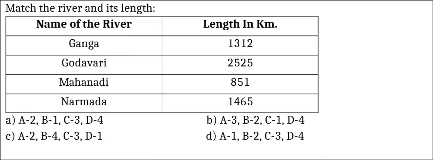
Match the river and its length: Name of the River — Ganga, Godavari, Mahanadi, Narmada; Length in Km — 1312, 2525, 851, 1465. What is the correct length of Ganga?
1312
2525
851
1465
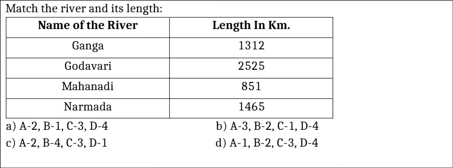
Match the river and its length: Name of the River — Ganga, Godavari, Mahanadi, Narmada; Length in Km — 1312, 2525, 851, 1465. What is the correct length of Godavari?
1312
2525
851
1465
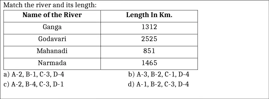
Match the river and its length: Name of the River — Ganga, Godavari, Mahanadi, Narmada; Length in Km — 1312, 2525, 851, 1465. What is the correct length of Mahanadi?
1312
2525
851
1465
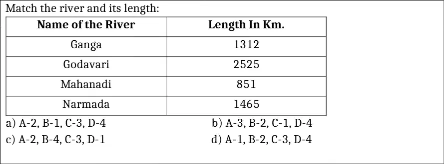
Match the river and its length: Name of the River — Ganga, Godavari, Mahanadi, Narmada; Length in Km — 1312, 2525, 851, 1465. What is the correct length of Narmada?
1312
2525
851
1465
Which of the following winds is responsible for the monsoon rains in India?
Westerlies
Polar Easterlies
Southwest Monsoon winds
Trade winds
Which forest type is known for having trees that shed their leaves in the dry season to conserve water?
Tropical evergreen forests
Tropical deciduous forests
Temperate forests
Coniferous forests

