
Wayground
Seismogram and Epicenter Quiz - Printable ศาสตร์ Worksheets ระดับ 6 - Wayground

Seismogram and Epicenter Quiz

Christopher Youngman

By Christopher Youngman

25 คำถาม

6th - 6th ระดับชั้น

ศาสตร์

19 เล่น

อัปเดตแล้ว ก.ย. 2568

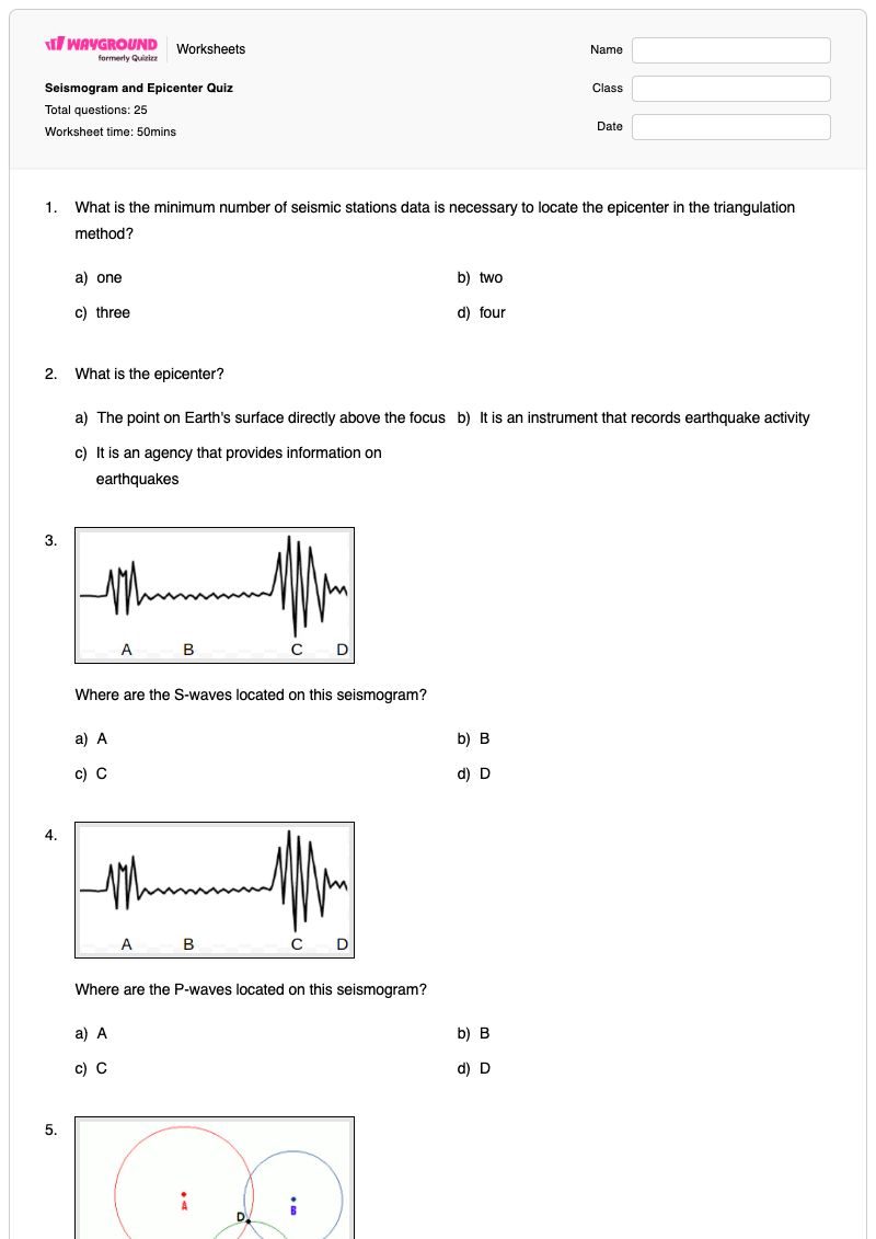
แบบทดสอบเรื่องคลื่นแผ่นดินไหวและจุดศูนย์กลางแผ่นดินไหว เป็นแบบฝึกหัดวิทยาศาสตร์สำหรับนักเรียนชั้นประถมศึกษาปีที่ 6 ที่ตรวจสอบความเข้าใจของนักเรียนเกี่ยวกับวิธีการที่นักแผ่นดินไหววิทยาใช้ข้อมูลคลื่นแผ่นดินไหวเพื่อระบุตำแหน่งจุดศูนย์กลางแผ่นดินไหว แบบฝึกหัดนี้ประกอบด้วยคำถาม 25 ข้อ—แบบเลือกตอบ 24 ข้อ และแบบเติมคำ 1 ข้อ—นักเรียนจะได้ระบุคลื่น P และคลื่น S บนคลื่นแผ่นดินไหว ตีความความแตกต่างของเวลาที่คลื่นมาถึง จดจำคลื่นแผ่นดินไหว และแยกแยะจุดศูนย์กลางแผ่นดินไหวออกจากคำศัพท์อื่นๆ ที่เกี่ยวข้องกับแผ่นดินไหว นอกจากนี้ นักเรียนยังจะได้ประยุกต์ใช้การหาตำแหน่งโดยใช้สามเหลี่ยม โดยการกำหนดจำนวนสถานีตรวจวัดแผ่นดินไหวหรือวงกลมบนแผนที่ที่จำเป็น เปรียบเทียบระยะห่างของสถานีจากจุดศูนย์กลางแผ่นดินไหว และตีความคลื่นแผ่นดินไหวและแผนภาพที่มีป้ายกำกับเพื่อระบุตำแหน่งจุดศูนย์กลางแผ่นดินไหว แบบฝึกหัดที่พิมพ์ได้ฟรีนี้มีเฉลยคำตอบครบถ้วน และเหมาะสำหรับการเรียนการสอนวิทยาศาสตร์ชั้นประถมศึกษาปีที่ 6 การฝึกฝนแบบมีผู้แนะนำ การทบทวน หรือการประเมินความสามารถของนักเรียนในการเชื่อมโยงหลักฐานการมาถึงของคลื่นกับการระบุตำแหน่งแผ่นดินไหว

การตั้งค่าแผ่นงาน

ขนาดตัวอักษร

S
M
L
XL
Waygroundแผ่นงาน

Seismogram and Epicenter Quiz

คำถามทั้งหมด: 25

ชื่อ
ระดับ
วันที่
1.

What is the minimum number of seismic stations data is necessary to locate the epicenter in the triangulation method?

a)

one

b)

two

c)

three

d)

four

2.

What is the epicenter?

a)

The point on Earth's surface directly above the focus

b)

It is an instrument that records earthquake activity

c)

It is an agency that provides information on earthquakes

3.
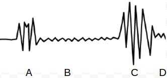
Where are the S-waves located on this seismogram?
a)
A
b)
B
c)
C
d)
D
4.
Where are the P-waves located on this seismogram?
a)
A
b)
B
c)
C
d)
D
5.
Where is the epicenter for this earthquake located based on triangulation?
a)
A
b)
B
c)
C
d)
D
6.

It is a method used to locate the epicenter of an earthquake.

a)

Echolocation

b)

Radar

c)

Experimentation

d)

Triangulation

7.
Which of the four seismic stations is located farthest from the epicenter?

Which of the four seismic stations is located farthest from

the epicenter?

a)

A

b)

B

c)

C

d)

D

8.
How can you tell that location X is closest to the epicenter of the earthquake? (think about distance)

How can you tell that location X is closest to the epicenter of the earthquake? (think about distance)

a)

It has the biggest circle

b)

It has the smallest circle

c)

It is a circle on the map

d)

It is located near the top right corner

9.
Which seismic station has the biggest difference (lag time) in the P wave arrival time and the S wave arrival time?

Which seismic station has the biggest difference (lag time) in the P wave arrival time and the S wave arrival time?

a)

X

b)

Y

c)

Z

10.
What is the difference in arrival times of the P and S waves?

What is the difference in arrival times of the P and S waves?

a)

5 min

b)

1 min

c)

4 min

d)

6 min

11.
Where is the epicenter located?

Where is the epicenter located?

a)

C

b)

D

c)

E

d)

G

12.
What is difference between the arrival times of the P- and S-waves?

What is difference between the arrival times of the P- and S-waves?

(a)  

13.

How many circles are needed to determine the epicenter of an earthquake?

a)

1

b)

2

c)

3

d)

5

14.
The first waves shown on a seismogram are
a)
p waves
b)
s waves
c)
surface waves
d)
aftershock waves
15.
A _____________________________ is the record of an earthquake's seismic waves produced by a seismograph.
a)
seismometer
b)
seismogram
c)
surface wave
d)
volcanometer
16.
The farther a seismic station is from an earthquake, a person will notice that the time between P and S waves (notice the…

The farther a seismic station is from an earthquake, a person will notice that  the time between P and S waves (notice the gap between the top and bottom line)

a)
Increases
b)
Decreases
c)
Same
17.
WHAT IS THE DIFFERENCE IN TIME THAT IT TOOK AN S WAVE AND P WAVE TO TRAVEL 2,000 KM?

WHAT IS THE DIFFERENCE IN TIME THAT IT TOOK AN S WAVE AND P WAVE TO TRAVEL 2,000 KM?

a)

10 MINUTES

b)

12 MINUTES

c)

3 MINUTES

18.
ACCORDING TO THE CHART HOW MANY KILOMETERS DID THE S WAVE TRAVEL IN 12 MINUTES?

ACCORDING TO THE CHART HOW MANY KILOMETERS DID THE S WAVE TRAVEL IN 12 MINUTES?

a)

2,000 KM

b)

4,000 KM

c)

6,000 KM

19.
HOW LONG DID IT TAKE THE P WAVE TO TRAVEL 2000 KM? (Hint: P-wave dot above 2,000Km)

HOW LONG DID IT TAKE THE P WAVE TO TRAVEL 2000 KM? (Hint: P-wave dot above 2,000Km)

a)

2 MIN

b)

4 MIN

c)

6 MIN

20.
Identify Item #3

Identify Item #3

a)

P-wave (Primary wave)

b)

S-wave (Secondary wave)

c)

Body waves

d)

Surface waves

21.
Identify Item #4

Identify Item #4

a)

P-wave (Primary wave)

b)

S-wave (Secondary wave)

c)

Body waves

d)

Surface waves

22.
Which letter shows the location of the EPICENTER?

Which letter shows the location of the EPICENTER?

a)

A

b)

B

23.
Which letter shows the location of the FOCUS?

Which letter shows the location of the FOCUS?

a)

A

b)

B

24.
Which city is the epicenter of the earthquake closest too?

Which city is the epicenter of the earthquake closest too?

a)

San Francisco

b)

Salt Lake City

25.
Which letter shows the start of the P WAVE in the seismogram? REMEMBER: P waves are the fastest waves.

Which letter shows the start of the P WAVE in the seismogram?

REMEMBER: P waves are the fastest waves.

a)

WAVE A

b)

WAVE B

c)

WAVE C

Waygroundแป้นคำตอบ

Seismogram and Epicenter Quiz

คำถามทั้งหมด: 25

1.
c)

three

2.
a)

The point on Earth's surface directly above the focus

3.
c) C
4.
a) A
5.
d) D
6.
d)

Triangulation

7.
c)

C

8.
b)

It has the smallest circle

9.
c)

Z

10.
c)

4 min

11.
b)

D

12.
7 minutes, 7
13.
c)

3

14.
a) p waves
15.
b) seismogram
16.
a) Increases
17.
c)

3 MINUTES

18.
b)

4,000 KM

19.
b)

4 MIN

20.
a)

P-wave (Primary wave)

21.
b)

S-wave (Secondary wave)

22.
a)

A

23.
b)

B

24.
a)

San Francisco

25.
a)

WAVE A

คำถามที่พบบ่อย

แบบฝึกหัดเรื่องแผนภูมิแผ่นดินไหวและจุดศูนย์กลางแผ่นดินไหวครอบคลุมเนื้อหาอะไรบ้าง?

แบบฝึกหัดวิทยาศาสตร์สำหรับนักเรียนชั้นประถมศึกษาปีที่ 6 นี้ ประกอบด้วยคำถามแบบเลือกตอบ 24 ข้อ และคำถามเติมคำในช่องว่าง 1 ข้อ เพื่อประเมินว่านักเรียนตีความคลื่นแผ่นดินไหวอย่างไร ระบุคลื่น P และคลื่น S เปรียบเทียบเวลาการมาถึงของคลื่นทั้งสอง และระบุตำแหน่งศูนย์กลางแผ่นดินไหวได้อย่างไร นอกจากนี้ นักเรียนยังต้องใช้หลักการสามเหลี่ยมในการวิเคราะห์ข้อมูลจากสถานีตรวจวัดแผ่นดินไหว ระยะห่างระหว่างสถานี และวงกลมบนแผนที่เพื่อกำหนดตำแหน่งศูนย์กลางแผ่นดินไหว

ฉันจะใช้แบบฝึกหัดนี้สอนนักเรียนเกี่ยวกับวิธีการระบุตำแหน่งจุดศูนย์กลางแผ่นดินไหวจากคลื่นแผ่นดินไหวได้อย่างไร?

เริ่มแบบฝึกหัดโดยทบทวนว่าคลื่น P ปรากฏก่อนคลื่น S และช่องว่างระหว่างการมาถึงของคลื่นทั้งสองให้ข้อมูลเกี่ยวกับระยะทาง จากนั้นสาธิตแผนภาพคลื่นไหวสะเทือนที่มีป้ายกำกับหนึ่งภาพและแผนภาพการหาตำแหน่งโดยใช้สามเหลี่ยมหนึ่งภาพ โดยขอให้นักเรียนอธิบายว่าข้อมูลจากสถานีตรวจวัดและวงกลมที่ตัดกันช่วยจำกัดตำแหน่งศูนย์กลางแผ่นดินไหวได้อย่างไร ก่อนที่พวกเขาจะทำแบบฝึกหัดที่เหลือด้วยตนเองหรือเป็นคู่

ฉันควรระวังข้อผิดพลาดอะไรบ้างเมื่อนักเรียนทำแบบฝึกหัดเรื่องแผนภูมิแผ่นดินไหวและจุดศูนย์กลางแผ่นดินไหวนี้?

ระวังนักเรียนอาจสับสนระหว่างจุดศูนย์กลางแผ่นดินไหวกับจุดกำเนิดแผ่นดินไหว เครื่องวัดแผ่นดินไหว หรือแผนภาพแผ่นดินไหว หรือสลับลำดับการมาถึงของคลื่น P และคลื่น S ในแผนภาพที่มีป้ายกำกับ นักเรียนอาจอ่านค่าเวลาหน่วงของคลื่น P และ S ผิด เลือกสถานีโดยพิจารณาจากตำแหน่งบนแผนที่แทนที่จะพิจารณาจากระยะทาง หรือลืมไปว่าการหาจุดศูนย์กลางแผ่นดินไหวโดยใช้วิธีสามเหลี่ยมต้องใช้จุดศูนย์กลางแผ่นดินไหวสามจุด

ฉันจะมอบหมายและให้คะแนนแบบทดสอบเรื่องแผนภูมิแผ่นดินไหวและจุดศูนย์กลางแผ่นดินไหวได้อย่างไร?

Wayground จัดทำแบบฝึกหัดนี้ในรูปแบบไฟล์ PDF ที่สามารถพิมพ์ได้ และในรูปแบบแบบทดสอบดิจิทัล โดยมีเฉลยคำตอบครบถ้วนสำหรับคำถามแบบเลือกตอบ 24 ข้อ และคำถามเติมคำในช่องว่าง สำหรับการส่งงานแบบพิมพ์ ครูสามารถสแกนงานของนักเรียนด้วยแอป Wayground for Teachers เพื่อตรวจให้คะแนนได้อย่างมีประสิทธิภาพ

ฉันจะปรับแบบฝึกหัดเรื่องแผนภูมิแผ่นดินไหวและจุดศูนย์กลางแผ่นดินไหวนี้ให้เหมาะสมกับนักเรียนของฉันได้อย่างไร?

ใช้การตั้งค่าขั้นสูงของแบบฝึกหัดเพื่อปรับระยะห่างระหว่างตัวอักษรและขนาดตัวอักษร เพื่อให้ป้ายกำกับกราฟแสดงตำแหน่งแผ่นดินไหว แผนภาพการหาตำแหน่งโดยใช้สามเหลี่ยม และตัวเลือกคำตอบอ่านง่ายขึ้น นอกจากนี้ คุณยังสามารถเปิดใช้งานแบบอักษรที่เหมาะสำหรับผู้ที่มีภาวะดิสเล็กเซีย หรือแปลแบบฝึกหัดเป็นภาษาอื่นโดยคงคำถามเกี่ยวกับข้อมูลแผ่นดินไหวเอาไว้ได้

ฉันจะหาแบบฝึกหัดแบบนี้เพิ่มเติมได้ที่ไหนบน Wayground?

Wayground มีแบบฝึกหัดและโจทย์ฝึกหัดมากมายให้ดาวน์โหลดฟรีในหลากหลายวิชา พร้อมไฟล์ PDF และเฉลยคำตอบ เพื่อช่วยเสริมสร้างทักษะและความเข้าใจในเนื้อหาสำคัญ ดูแหล่งข้อมูลเพิ่มเติมได้ที่ https://wayground.com/en-us/worksheets