Wayground
Continents & Oceans - Printable สังคมศึกษา Worksheets ระดับ 4 - Wayground

Continents & Oceans

Connor Munisteri

สร้างโดย Connor Munisteri

17 คำถาม

4th ระดับชั้น

สังคมศึกษา

อัปเดตแล้ว ก.ย. 2569

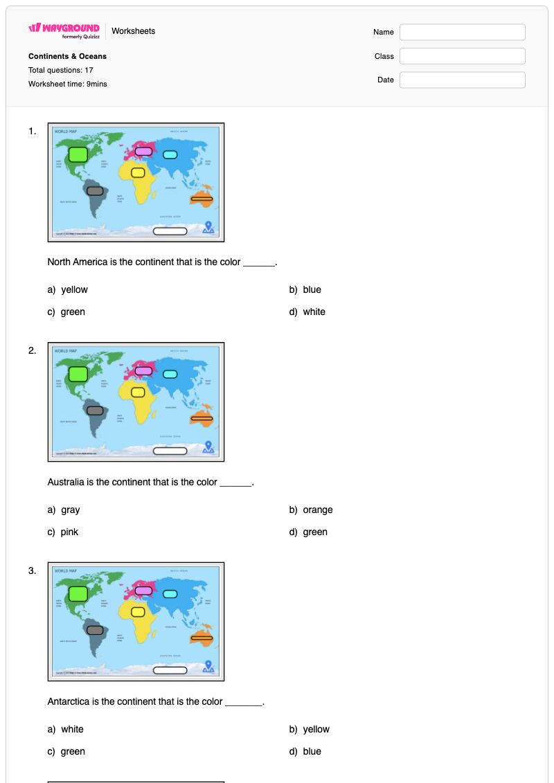
แบบฝึกหัดวิชาสังคมศึกษา ชั้นประถมศึกษาปีที่ 4 นี้ ช่วยให้นักเรียนได้ฝึกฝนการระบุทวีปทั้งเจ็ดและมหาสมุทรทั้งห้าอย่างมีประสิทธิภาพ แบบฝึกหัดประกอบด้วยคำถามแบบเลือกตอบ 17 ข้อ โดยนักเรียนจะต้องจับคู่ทวีปกับสีที่กำหนด ระบุมหาสมุทรจากหมายเลขอ้างอิงบนแผนที่ จดจำจำนวนทวีปและมหาสมุทรทั้งหมด และระบุว่ามหาสมุทรแปซิฟิกเป็นมหาสมุทรที่ใหญ่ที่สุด คำถามเหล่านี้ช่วยเสริมสร้างทั้งคำศัพท์ทางภูมิศาสตร์และหลักการอ่านแผนที่โลก ใช้แบบฝึกหัดที่พิมพ์ได้ฟรีนี้เพื่อตรวจสอบว่านักเรียนสามารถเชื่อมโยงชื่อทวีปกับตำแหน่งที่กำหนดด้วยสี และชื่อมหาสมุทรกับตำแหน่งที่กำหนดด้วยหมายเลขได้หรือไม่ แทนที่จะพึ่งพาเพียงแค่การท่องจำ แบบฝึกหัดนี้เหมาะสำหรับการฝึกฝนด้วยตนเอง การทบทวนภูมิศาสตร์ หรือการประเมินผลสั้นๆ หลังจากการแนะนำทวีปทั้งเจ็ดและมหาสมุทรทั้งห้า แบบฝึกหัดนี้มีเฉลยคำตอบครบถ้วนเพื่อการตรวจสอบและให้ข้อเสนอแนะอย่างมีประสิทธิภาพ

การตั้งค่าแผ่นงาน

ขนาดตัวอักษร

S
M
L
XL
Waygroundแผ่นงาน

Continents & Oceans

คำถามทั้งหมด: 17

ชื่อ
ระดับ
วันที่
1.
North America is the continent that is the color ______.

North America is the continent that is the color ______.

a)

yellow

b)

blue

c)

green

d)

white

2.
Australia is the continent that is the color ______.

Australia is the continent that is the color ______.

a)

gray

b)

orange

c)

pink

d)

green

3.
Antarctica is the continent that is the color _______.

Antarctica is the continent that is the color _______.

a)

white

b)

yellow

c)

green

d)

blue

4.
Europe is the continent that is the color ____.

Europe is the continent that is the color ____.

a)

gray

b)

green

c)

orange

d)

pink

5.
Africa is the continent that is the color ____.

Africa is the continent that is the color ____.

a)

gray

b)

yellow

c)

orange

d)

green

6.
South America is the continent that is the color ____.

South America is the continent that is the color ____.

a)

white

b)

green

c)

gray

d)

blue

7.
Asia is the continent that is the color _____.

Asia is the continent that is the color _____.

a)

blue

b)

orange

c)

green

d)

pink

8.
Which ocean is number 1?

Which ocean is number 1?

a)

Pacific Ocean

b)

Atlantic Ocean

c)

Indian Ocean

d)

Arctic Ocean

9.
Which ocean is number 3?

Which ocean is number 3?

a)

Atlantic Ocean

b)

Indian Ocean

c)

Southern Ocean

d)

Pacific Ocean

10.
Which ocean is number 5?

Which ocean is number 5?

a)

Southern Ocean

b)

Pacific Ocean

c)

Indian Ocean

d)

Atlantic Ocean

11.
Which ocean is number 2?

Which ocean is number 2?

a)

Atlantic Ocean

b)

Pacific Ocean

c)

Indian Ocean

d)

Southern Ocean

12.
Which ocean is number 4?

Which ocean is number 4?

a)

Atlantic Ocean

b)

Arctic Ocean

c)

Southern Ocean

d)

Pacific Ocean

13.

How many continents are there in the world?

a)

5

b)

6

c)

7

d)

8

14.

How many oceans are there in the world?

a)

5

b)

6

c)

7

d)

8

15.

Which ocean is the largest?

a)

Arctic Ocean

b)

Pacific Ocean

c)

Atlantic Ocean

d)

Southern Ocean

16.
What is this symbol?

What is this symbol?

a)

scale

b)

key

c)

compass rose

d)

map

17.
What are the 4 cardinal direction ?

What are the 4 cardinal direction ?

a)

North- East - South - West

b)

Up - Right - Down - Left

c)

sun - fire - wind - Sea

d)

big - small - fat - thin

Waygroundแป้นคำตอบ

Continents & Oceans

คำถามทั้งหมด: 17

1.
c)

green

2.
b)

orange

3.
a)

white

4.
d)

pink

5.
b)

yellow

6.
c)

gray

7.
a)

blue

8.
a)

Pacific Ocean

9.
b)

Indian Ocean

10.
a)

Southern Ocean

11.
a)

Atlantic Ocean

12.
b)

Arctic Ocean

13.
c)

7

14.
a)

5

15.
b)

Pacific Ocean

16.
c)

compass rose

17.
a)

North- East - South - West

คำถามที่พบบ่อย

แบบฝึกหัดเรื่องทวีปและมหาสมุทรครอบคลุมเนื้อหาอะไรบ้าง?

แบบฝึกหัดสำหรับนักเรียนชั้นประถมศึกษาปีที่ 4 นี้ ประกอบด้วยคำถามแบบเลือกตอบ 17 ข้อ เพื่อฝึกฝนการระบุทวีปทั้งเจ็ดโดยใช้สีที่กำหนด และมหาสมุทรทั้งห้าโดยใช้หมายเลขกำกับ นอกจากนี้ยังตรวจสอบความสามารถของนักเรียนในการจดจำจำนวนทวีปและมหาสมุทร และระบุว่ามหาสมุทรแปซิฟิกเป็นมหาสมุทรที่ใหญ่ที่สุด

ฉันจะใช้แบบฝึกหัดนี้สอนเรื่องทวีปทั้งเจ็ดและมหาสมุทรทั้งห้าได้อย่างไร?

ขั้นแรก นำแผนที่โลกที่มีป้ายกำกับมาให้นักเรียนดู และให้นักเรียนลากเส้นตามทวีปที่ระบายสีไว้ และหาหมายเลขของมหาสมุทรที่ระบุไว้ จากนั้นใช้แบบฝึกหัดแบบเลือกตอบเพื่อฝึกฝน โดยให้นักเรียนอธิบายว่าพวกเขาจับคู่สีหรือหมายเลขใดกับทวีปหรือมหาสมุทรได้อย่างไร จบด้วยการอภิปรายคำถามเกี่ยวกับการนับ และข้อที่ระบุว่ามหาสมุทรแปซิฟิกเป็นมหาสมุทรที่ใหญ่ที่สุด

ฉันควรสังเกตข้อผิดพลาดอะไรบ้างเมื่อนักเรียนทำแบบฝึกหัดนี้เสร็จ?

นักเรียนอาจสับสนระหว่างสีที่ระบุไว้กับทวีปที่มีลักษณะคล้ายกัน โดยเฉพาะอย่างยิ่งเมื่อนึกถึงการจับคู่สีทวีปโดยไม่มีแผนที่อยู่ตรงหน้า พวกเขายังอาจสับสนเรื่องจำนวนมหาสมุทร สับสนระหว่างมหาสมุทรห้าแห่งกับทวีปเจ็ดแห่ง หรือเลือกมหาสมุทรอื่นแทนที่จะเป็นมหาสมุทรแปซิฟิกสำหรับคำถามเกี่ยวกับมหาสมุทรที่ใหญ่ที่สุด

ฉันจะมอบหมายและตรวจงานเรื่องทวีปและมหาสมุทรนี้อย่างไร?

คุณสามารถมอบหมายงานบน Wayground ในรูปแบบไฟล์ PDF ที่พิมพ์ได้ หรือเป็นแบบทดสอบดิจิทัล และมีเฉลยคำตอบครบถ้วนสำหรับคำถามแบบเลือกตอบทั้ง 17 ข้อ สำหรับการส่งงานแบบพิมพ์ได้ ให้สแกนงานของนักเรียนด้วยแอป Wayground for Teachers เพื่อให้การตรวจงานง่ายขึ้น ตัวเลือก PDF ยังช่วยสนับสนุนโรงเรียนที่ต้องการลดเวลาการใช้หน้าจอได้อีกด้วย

ฉันจะปรับแบบฝึกหัดนี้ให้เหมาะสมกับนักเรียนของฉันได้อย่างไร?

ในการตั้งค่าขั้นสูงของแบบฝึกหัด ให้ปรับระยะห่างระหว่างตัวอักษรหรือขนาดตัวอักษรเพื่อให้คำถามเกี่ยวกับสีของทวีปและหมายเลขของมหาสมุทรอ่านง่ายขึ้น นอกจากนี้ คุณยังสามารถเปิดใช้งานแบบอักษรที่เหมาะสำหรับผู้ที่มีภาวะดิสเล็กเซีย หรือแปลแบบฝึกหัดเป็นภาษาอื่นได้ เมื่อตัวเลือกเหล่านั้นช่วยให้เข้าถึงคำแนะนำและตัวเลือกแบบปรนัยได้ง่ายขึ้น

ฉันจะหาแบบฝึกหัดแบบนี้เพิ่มเติมได้ที่ไหนบน Wayground?

Wayground นำเสนอชุดแบบฝึกหัดและโจทย์ฝึกหัดฟรีที่ครอบคลุมหลากหลายวิชา พร้อมไฟล์ PDF และเฉลยคำตอบ เพื่อช่วยให้นักเรียนเชี่ยวชาญทักษะและแนวคิดที่สำคัญ ดูแหล่งข้อมูลเพิ่มเติมได้ที่ https://wayground.com/en-us/worksheets