

Wayground
4 Regions of Texas - Printable สังคมศึกษา Worksheets 7th ระดับชั้น - Wayground

4 Regions of Texas

Coach Campbell

สร้างโดย Coach Campbell

20 คำถาม

7th ระดับชั้น

สังคมศึกษา

อัปเดตแล้ว ก.ย. 2569

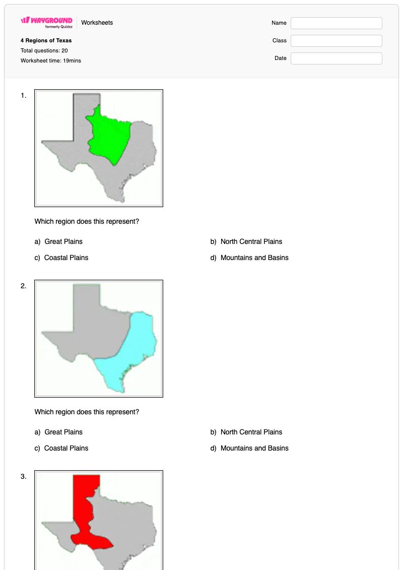
แบบฝึกหัดประวัติศาสตร์สำหรับนักเรียนชั้น ม.1 นี้ ช่วยให้นักเรียนระบุและเปรียบเทียบภูมิภาคหลักทั้งสี่ของรัฐเท็กซัส ได้แก่ ที่ราบชายฝั่ง ที่ราบตอนกลางตอนเหนือ ที่ราบใหญ่ และภูเขาและแอ่งน้ำ แบบฝึกหัดประกอบด้วยคำถามแบบเลือกตอบ 20 ข้อ นักเรียนจะใช้คำอธิบายภูมิภาค ความเชื่อมโยงกับเมืองและสถานที่สำคัญ แม่น้ำ สภาพภูมิอากาศ ประชากร ปริมาณน้ำฝน และลักษณะทางกายภาพ เพื่อเลือกภูมิภาคที่ถูกต้อง คำถามยังช่วยเสริมความเข้าใจเกี่ยวกับภูมิศาสตร์ที่สำคัญของรัฐเท็กซัส เช่น แม่น้ำริโอแกรนด์ ยอดเขากัวดาลูป หุบเขาพาโลดูโร ความเสี่ยงจากพายุเฮอริเคน และรูปแบบประชากรในแต่ละภูมิภาค ใช้แบบฝึกหัดที่พิมพ์ได้ฟรีนี้เพื่อตรวจสอบว่านักเรียนสามารถเชื่อมโยงเบาะแสทางภูมิศาสตร์กับภูมิภาคที่ถูกต้องของรัฐเท็กซัสได้หรือไม่ แทนที่จะพึ่งพาเพียงชื่อที่ท่องจำ มีเฉลยคำตอบครบถ้วนเพื่อการตรวจสอบและตรวจให้คะแนนอย่างมีประสิทธิภาพ

การตั้งค่าแผ่นงาน

ขนาดตัวอักษร

S
M
L
XL
Waygroundแผ่นงาน

4 Regions of Texas

คำถามทั้งหมด: 20

ชื่อ
ระดับ
วันที่
1.
Which region does this represent?
a)
Great Plains
b)
North Central Plains
c)
Coastal Plains
d)
Mountains and Basins
2.
Which region does this represent?
a)
Great Plains
b)
North Central Plains
c)
Coastal Plains
d)
Mountains and Basins
3.
Which region does this represent?
a)
Great Plains
b)
North Central Plains
c)
Coastal Plains
d)
Mountains and Basins
4.
Which region does this represent?
a)
Great Plains
b)
North Central Plains
c)
Coastal Plains
d)
Mountains and Basins
5.
What region of Texas is between the Rio Grande River and the Pecos River?
a)
Mountains and Basins
b)
Central Plains
c)
High Plains
d)
Coastal Plains
6.
What region has the cities of Houston, San Antonio, Dallas, Austin, and Corpus Christi?
a)
Mountains and Basins
b)
High Plains
c)
Coastal Plains
d)
Central Plains
7.
What region of Texas has a high risk of hurricanes?
a)
Mountains and Basins
b)
High Plains
c)
Central Plains
d)
Coastal Plains
8.
Located in the Mountains and Basins, what is the highest point in Texas?
a)
Davis Mountains
b)
Chisos Mountians
c)
Guadalupe Peak
d)
Rocky Mountains
9.
What river forms the boundary between Texas and Mexico?
a)
Red River
b)
Rio Grande River
c)
Lake Travis
d)
Colorado River
10.
What correctly describes the Mountains and Basins region?
a)
Least amount of rain and least populated
b)
Most amount of rain
c)
More people live here than in any other region
d)
Largest region
11.
Texas Region with flat, treeless plains and grasslands, Palo Duro Canyon?
a)
Coastal Plains
b)
North Central Plains
c)
Great Plains
d)
Mountains and Basins
12.
Texas Region where Dallas is located?
a)
Coastal Plains
b)
North Central Plains
c)
Great Plains
d)
Mountains and Basins
13.
Texas Region where the city Ft. Worth is located? (the largest city in that region)
a)
Coastal Plains
b)
North Central Plains
c)
Great Plains
d)
Mountains and Basins
14.
Texas Region with the smallest population?
a)
Coastal Plains
b)
North Central Plains
c)
Great Plains
d)
Mountains and Basins
15.
Texas Region where the Lake Caddo is located?
a)
Coastal Plains
b)
North Central Plains
c)
Great Plains
d)
Mountains and Basins
16.
Texas Region where the cities Lubbock and Amarillo are located?
a)
Coastal Plains
b)
North Central Plains
c)
Great Plains
d)
Mountains and Basins
17.
What is the climate like in the Mountains and Basins region?
a)
Cool and dry
b)
Hot and dry
c)
Hot and wet
d)
Cool and wet
18.
What are regions?
What are regions?
a)
Bodies of water
b)
Areas of land with physical features that set them apart from other areas of land
c)
A group of people with a shared set of beliefs, goals and religious customs.
d)
People who study the past.
19.
The Great Plains Region offered what type of economic activities?
a)
climate
b)
birds
c)
ocean
d)
farm crops
20.
The Red River makes the border on the Northern part of Texas.
a)
TRUE
b)
FALSE
Waygroundแป้นคำตอบ

4 Regions of Texas

คำถามทั้งหมด: 20

1.
b) North Central Plains
2.
c) Coastal Plains
3.
a) Great Plains
4.
d) Mountains and Basins
5.
a) Mountains and Basins
6.
c) Coastal Plains
7.
d) Coastal Plains
8.
c) Guadalupe Peak
9.
b) Rio Grande River
10.
a) Least amount of rain and least populated
11.
c) Great Plains
12.
a) Coastal Plains
13.
b) North Central Plains
14.
d) Mountains and Basins
15.
a) Coastal Plains
16.
c) Great Plains
17.
b) Hot and dry
18.
b) Areas of land with physical features that set them apart from other areas of land
19.
d) farm crops
20.
a) TRUE

คำถามที่พบบ่อย

แบบฝึกหัดนี้ครอบคลุมเนื้อหาอะไรบ้างเกี่ยวกับสี่ภูมิภาคของรัฐเท็กซัส?

แบบฝึกหัดประวัติศาสตร์ชั้น ม.1 นี้ประกอบด้วยคำถามแบบเลือกตอบ 20 ข้อ เพื่อประเมินว่านักเรียนสามารถระบุที่ราบชายฝั่ง ที่ราบตอนกลางตอนเหนือ ที่ราบใหญ่ และภูเขาและแอ่งต่างๆ จากข้อมูลทางภูมิศาสตร์ได้หรือไม่ นักเรียนจะต้องเชื่อมโยงแต่ละภูมิภาคกับลักษณะทางภูมิศาสตร์ เช่น เมือง แม่น้ำ ปริมาณน้ำฝน ประชากร ความเสี่ยงจากพายุเฮอริเคน ยอดเขากัวดาลูป และหุบเขาพาโลดูโร เพื่อสร้างความรู้ด้านภูมิศาสตร์ของรัฐเท็กซัสที่อิงตามสถานที่ตั้ง

ฉันจะใช้แบบฝึกหัดนี้ในการสอนเรื่องภูมิภาคทั้งสี่ของรัฐเท็กซัสได้อย่างไร?

แนะนำชื่อภูมิภาคทั้งสี่โดยใช้แผนที่หรือแผนภูมิประกอบการสอน จากนั้นให้นักเรียนจัดเรียงเบาะแสในใบงานเป็นหมวดหมู่ เช่น ลักษณะทางกายภาพ เมือง ทางน้ำ สภาพภูมิอากาศ และจำนวนประชากร หลังจากที่นักเรียนตอบคำถามแบบเลือกตอบเสร็จแล้ว ให้พูดคุยกันว่าทำไมเบาะแสต่างๆ เช่น แม่น้ำริโอแกรนด์ ยอดเขากัวดาลูป หุบเขาพาโลดูโร และความเสี่ยงจากพายุเฮอริเคน จึงชี้ไปยังภูมิภาคใดภูมิภาคหนึ่ง ขอให้นักเรียนอธิบายเบาะแสที่สนับสนุนคำตอบที่เลือกแต่ละข้อ แทนที่จะเพียงแค่บอกชื่อภูมิภาค

ฉันควรระวังข้อผิดพลาดอะไรบ้างเมื่อนักเรียนทำแบบฝึกหัดเกี่ยวกับภูมิภาคต่างๆ ของรัฐเท็กซัสนี้?

นักเรียนอาจเลือกภูมิภาคจากชื่อสถานที่ที่คุ้นเคยโดยไม่ตรวจสอบเบาะแสอื่นๆ โดยเฉพาะอย่างยิ่งในคำถามที่เกี่ยวข้องกับดัลลัส ฟอร์ตเวิร์ธ ฮิวสตัน ซานอันโตนิโอ ออสติน คอร์ปัสคริสตี หรือทะเลสาบแคดโด พวกเขาอาจสับสนแม่น้ำริโอแกรนด์กับแหล่งน้ำอื่นๆ ที่ระบุไว้ มองข้ามความแตกต่างระหว่างที่ราบใหญ่และที่ราบตอนกลางเหนือ หรือพลาดไปว่าแบบฝึกหัดเชื่อมโยงภูเขาและแอ่งน้ำกับพื้นที่ที่มีปริมาณน้ำฝนน้อยและประชากรน้อยที่สุด ทบทวนเบาะแสที่แตกต่างกันในแต่ละข้อที่เลือกผิด

ฉันจะมอบหมายและให้คะแนนแบบฝึกหัดเกี่ยวกับสี่ภูมิภาคของรัฐเท็กซัสได้อย่างไร?

คุณสามารถมอบหมายแบบฝึกหัดนี้เป็นไฟล์ PDF ที่พิมพ์ได้ หรือเป็นแบบทดสอบดิจิทัลบน Wayground แบบฝึกหัดนี้มีเฉลยคำตอบครบถ้วน และสามารถตรวจงานส่งของนักเรียนได้โดยการสแกนงานของนักเรียนด้วยแอป Wayground for Teachers ตัวเลือกไฟล์ PDF ยังช่วยสนับสนุนห้องเรียนที่ลดเวลาการใช้หน้าจอในขณะที่นักเรียนฝึกฝนการระบุภูมิภาคต่างๆ ของรัฐเท็กซัสได้อีกด้วย

ฉันจะปรับแบบฝึกหัดเรื่องสี่ภูมิภาคของเท็กซัสนี้ให้เหมาะสมกับนักเรียนของฉันได้อย่างไร?

สำหรับข้อสอบแบบเลือกตอบ ให้ใช้การตั้งค่าขั้นสูงของแบบฝึกหัดเพื่อปรับระยะห่างระหว่างตัวอักษรและขนาดตัวอักษร เพื่อให้ชื่อภูมิภาคและคำใบ้ทางภูมิศาสตร์อ่านง่ายขึ้น นอกจากนี้ คุณยังสามารถเลือกใช้แบบอักษรที่เหมาะสำหรับผู้ที่มีภาวะดิสเล็กเซีย หรือแปลแบบฝึกหัดเป็นภาษาอื่นได้ หากตัวเลือกเหล่านั้นช่วยให้เข้าถึงคำถามและตัวเลือกคำตอบได้ดียิ่งขึ้น

ฉันจะหาแบบฝึกหัดแบบนี้เพิ่มเติมได้ที่ไหนบน Wayground?

Wayground มีแบบฝึกหัดและโจทย์ฝึกหัดมากมายให้ดาวน์โหลดฟรีในหลากหลายวิชา พร้อมไฟล์ PDF และเฉลยคำตอบ เพื่อช่วยให้นักเรียนพัฒนาทักษะและความเข้าใจในแนวคิดสำคัญๆ ดูแหล่งข้อมูลเพิ่มเติมได้ที่ https://wayground.com/en-us/worksheets