

Wayground
Earthquakes - Printable ศาสตร์ Worksheets 10th - 10th ระดับชั้น - Wayground

Earthquakes

Conan McCormack

By Conan McCormack

20 คำถาม

10th - 10th ระดับชั้น

ศาสตร์

324 เล่น

อัปเดตแล้ว ก.ย. 2569

แบบฝึกหัดวิทยาศาสตร์สำหรับนักเรียนชั้นมัธยมศึกษาปีที่ 4 เรื่องแผ่นดินไหว ประกอบด้วยคำถามแบบเลือกตอบ 20 ข้อ เพื่อประเมินความเข้าใจพื้นฐานเกี่ยวกับแผ่นดินไหว นักเรียนจะได้ระบุความหมายของรอยเลื่อน จุดกำเนิดแผ่นดินไหว และจุดศูนย์กลางแผ่นดินไหว แยกแยะคุณสมบัติของคลื่น P และคลื่น S ตีความสิ่งที่กราฟเวลาเดินทางแสดง และเชื่อมโยงการกระจายตัวของแผ่นดินไหวกับขอบมหาสมุทรแปซิฟิก คำถามยังครอบคลุมถึงการปลดปล่อยพลังงานยืดหยุ่น ขนาดของแผ่นดินไหว และมาตราความรุนแรงของแผ่นดินไหวแบบโมเมนต์ด้วย

การตั้งค่าแผ่นงาน

ขนาดตัวอักษร

S
M
L
XL
Waygroundแผ่นงาน

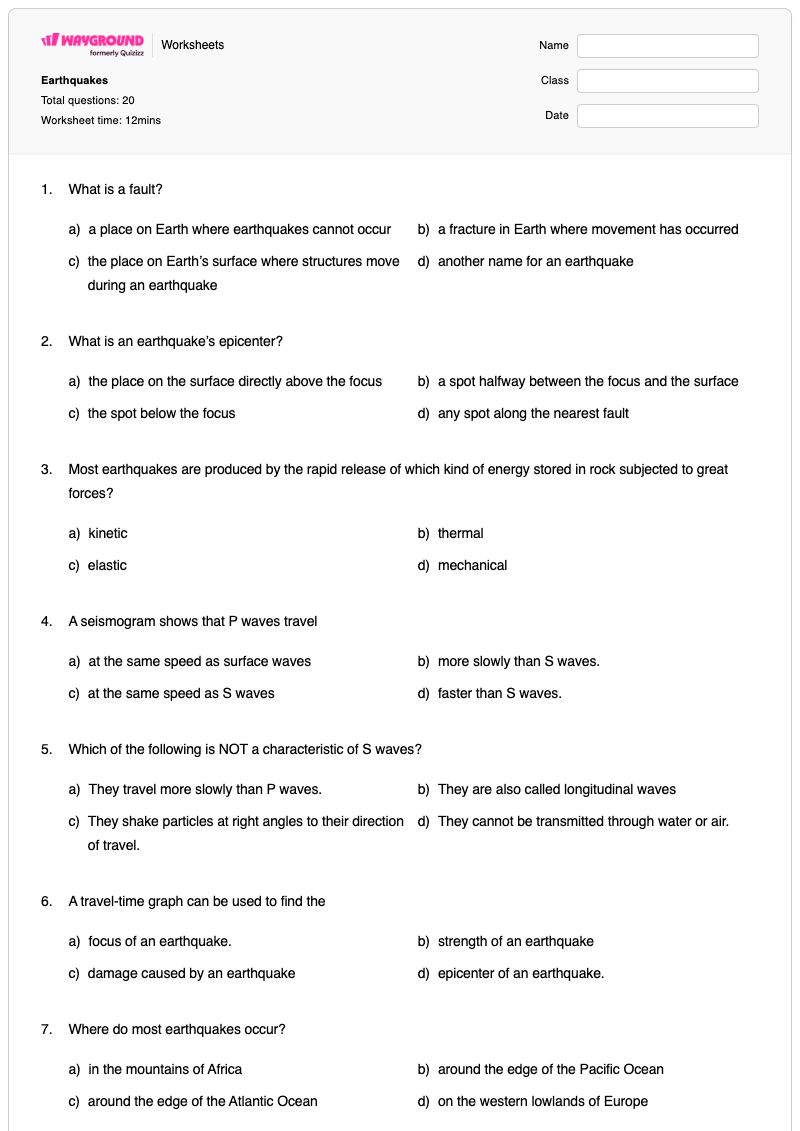
Earthquakes

คำถามทั้งหมด: 20

ชื่อ
ระดับ
วันที่
1.

What is a fault?

a)

a place on Earth where earthquakes cannot occur

b)

a fracture in Earth where movement has occurred

c)

the place on Earth’s surface where structures move during an earthquake

d)

another name for an earthquake

2.

What is an earthquake’s epicenter?

a)

the place on the surface directly above the focus

b)

a spot halfway between the focus and the surface

c)

the spot below the focus

d)

any spot along the nearest fault

3.

Most earthquakes are produced by the rapid release of which kind of energy stored in rock subjected to great forces?

a)

kinetic

b)

thermal

c)

elastic

d)

mechanical

4.

A seismogram shows that P waves travel

a)

at the same speed as surface waves

b)

more slowly than S waves.

c)

at the same speed as S waves

d)

faster than S waves.

5.

Which of the following is NOT a characteristic of S waves?

a)

They travel more slowly than P waves.

b)

They are also called longitudinal waves

c)

They shake particles at right angles to their direction of travel.

d)

They cannot be transmitted through water or air.

6.

A travel-time graph can be used to find the

a)

focus of an earthquake.

b)

strength of an earthquake

c)

damage caused by an earthquake

d)

epicenter of an earthquake.

7.

Where do most earthquakes occur?

a)

in the mountains of Africa

b)

around the edge of the Pacific Ocean

c)

around the edge of the Atlantic Ocean

d)

on the western lowlands of Europe

8.

An earthquake’s magnitude is a measure of the

a)

size of seismic waves it produces.

b)

amount of shaking it produces.

c)

size of surface waves it produces.

d)

damage it causes.

9.

What measurement for earthquake do scientists use most often today?

a)

seismic scale

b)

Richter scale

c)

moment magnitude scale

d)

epicenter magnitude scale

10.

The moment magnitude is calculated using all of the following factors EXCEPT for the

a)

surface area of a fault

b)

magnitude of past earthquakes in the area.

c)

average displacement along a fault.

d)

rigidity of rock in the area.

11.

Liquefaction occurs when

a)

large waves wash over coastal areas and destroystructures

b)

earthquakes occur in the ocean and damage ships at sea.

c)

loose, saturated soil turns into liquid that can’t support buildings.

d)

mud slides downhill and buries buildings.

12.

A tsunami can occur when there is vertical movement at a fault under

a)

a mountain range.

b)

            the San Andreas Fault.

c)

the ocean floor.

d)

a small inland lake.

13.

Violent shaking from an earthquake can cause soil and rock on slopes to move and cause a

a)

fault

b)

landslide

c)

tsunami

d)

sinkhole

14.

Which of the following is used to determine earthquake risk?

a)

strain in rocks near faults

b)

height of ocean waves after earthquakes

c)

changes in the color of rocks near faults

d)

hydrogen gas emissions near fractures

15.

Earth’s thin, rocky outer layer is its

a)

core

b)

mantle

c)

crust

d)

outer core

16.

The Earth’s core is made of an alloy of

a)

iron and nickel.

b)

copper and iron.

c)

zinc and magnesium.

d)

iron and zinc.

17.

What does Earth’s crust and uppermost mantle form?

a)

asthenosphere

b)

hydrosphere

c)

lithosphere

d)

atmosphere

18.

Earth’s inner core is solid because of

a)

the composition of its rock.

b)

its great diameter.

c)

extreme cold.

d)

immense pressure.

19.

What is the Moho?

a)

the boundary between the outer and inner core

b)

the boundary between the crust and the mantle

c)

the material of which the mantle is composed

d)

an area of the mantle that will not transmit seismic waves

20.

The continental crust is made largely of

a)

gneiss

b)

granite

c)

basalt

d)

limestone

Waygroundแป้นคำตอบ

Earthquakes

คำถามทั้งหมด: 20

1.
b)

a fracture in Earth where movement has occurred

2.
a)

the place on the surface directly above the focus

3.
c)

elastic

4.
d)

faster than S waves.

5.
b)

They are also called longitudinal waves

6.
d)

epicenter of an earthquake.

7.
b)

around the edge of the Pacific Ocean

8.
a)

size of seismic waves it produces.

9.
c)

moment magnitude scale

10.
b)

magnitude of past earthquakes in the area.

11.
c)

loose, saturated soil turns into liquid that can’t support buildings.

12.
c)

the ocean floor.

13.
b)

landslide

14.
a)

strain in rocks near faults

15.
c)

crust

16.
a)

iron and nickel.

17.
c)

lithosphere

18.
d)

immense pressure.

19.
b)

the boundary between the crust and the mantle

20.
b)

granite

คำถามที่พบบ่อย

แบบฝึกหัดเรื่องแผ่นดินไหวนี้ครอบคลุมเนื้อหาอะไรบ้าง?

แบบฝึกหัดวิทยาศาสตร์สำหรับนักเรียนชั้น ม.4 นี้ ประกอบด้วยคำถามแบบเลือกตอบ 20 ข้อ เพื่อสร้างความเข้าใจเกี่ยวกับโครงสร้างของแผ่นดินไหว คลื่นแผ่นดินไหว การวัด และอันตรายจากแผ่นดินไหว นักเรียนจะสามารถแยกแยะความแตกต่างระหว่างรอยเลื่อน จุดกำเนิดแผ่นดินไหว และจุดศูนย์กลางแผ่นดินไหว เปรียบเทียบคลื่น P และคลื่น S ระบุว่ากราฟเวลาเดินทางช่วยในการระบุตำแหน่งจุดศูนย์กลางแผ่นดินไหวได้อย่างไร และประยุกต์ใช้แนวคิดต่างๆ เช่น ขนาดแผ่นดินไหว การเกิดปรากฏการณ์ดินเหลว สึนามิ ดินถล่ม และความเสี่ยงจากแผ่นดินไหว

ฉันจะใช้แบบฝึกหัดนี้ในการสอนแนวคิดเกี่ยวกับแผ่นดินไหวได้อย่างไร?

หลังจากที่นักเรียนได้เรียนรู้คำศัพท์เกี่ยวกับรอยเลื่อน จุดกำเนิดแผ่นดินไหว จุดศูนย์กลางแผ่นดินไหว และคลื่นแผ่นดินไหวแล้ว ให้เริ่มทำแบบฝึกหัดนี้ ให้นักเรียนอธิบายเหตุผลในการเลือกคำตอบสำหรับคำถามเกี่ยวกับคลื่น P และคลื่น S จากนั้นใช้ข้อมูลเกี่ยวกับกราฟเวลาเดินทางของคลื่น ขนาดแผ่นดินไหว การเกิดปรากฏการณ์ดินเหลว และสึนามิ เพื่อเชื่อมโยงกระบวนการทางแผ่นดินไหวกับอันตรายจากแผ่นดินไหว

ฉันควรระวังข้อผิดพลาดอะไรบ้างเมื่อนักเรียนทำแบบฝึกหัดเกี่ยวกับแผ่นดินไหวนี้?

นักเรียนอาจสับสนระหว่างจุดกำเนิดแผ่นดินไหวกับจุดศูนย์กลางแผ่นดินไหว หรือเข้าใจผิดว่ารอยเลื่อนคือจุดบนพื้นผิวโลกที่อยู่เหนือจุดกำเนิดแผ่นดินไหว ควรสังเกตการเปลี่ยนแปลงคุณสมบัติของคลื่น P และคลื่น S โดยเฉพาะอย่างยิ่งการระบุว่าคลื่น S เป็นคลื่นตามยาว หรือสันนิษฐานว่าคลื่น S เดินทางผ่านน้ำและอากาศ นักเรียนอาจสับสนระหว่างขนาดของแผ่นดินไหว (magnitude) กับความเสียหายหรือการสั่นสะเทือน และสับสนระหว่างปรากฏการณ์ดินเหลว (liquefaction) กับดินถล่มหรือสึนามิ

ฉันจะมอบหมายและให้คะแนนแบบฝึกหัดเรื่องแผ่นดินไหวนี้อย่างไร?

แบบฝึกหัดนี้มีให้ดาวน์โหลดในรูปแบบไฟล์ PDF สำหรับพิมพ์ และเป็นแบบทดสอบดิจิทัลบน Wayground โดยมีเฉลยคำตอบครบถ้วนสำหรับคำถามแบบเลือกตอบทั้ง 20 ข้อ คุณสามารถตรวจงานที่ส่งในรูปแบบไฟล์ PDF ได้โดยการสแกนงานของนักเรียนด้วยแอป Wayground for Teachers ในขณะที่แบบทดสอบดิจิทัลรองรับการมอบหมายงานและการตรวจให้คะแนนทางออนไลน์

ฉันจะปรับแบบฝึกหัดเรื่องแผ่นดินไหวนี้ให้เหมาะสมกับนักเรียนของฉันได้อย่างไร?

ใช้การตั้งค่าขั้นสูงของแบบฝึกหัดเพื่อปรับระยะห่างระหว่างตัวอักษรหรือขนาดตัวอักษร เพื่อให้คำถามแบบเลือกตอบ 20 ข้ออ่านง่ายขึ้น นอกจากนี้ คุณยังสามารถเปิดใช้งานแบบอักษรที่เหมาะสำหรับผู้ที่มีภาวะดิสเล็กเซีย หรือแปลคำศัพท์เกี่ยวกับแผ่นดินไหวและตัวเลือกคำตอบเป็นภาษาอื่นได้ตามความเหมาะสม

ฉันจะหาแบบฝึกหัดแบบนี้เพิ่มเติมได้ที่ไหนบน Wayground?

Wayground นำเสนอชุดแบบฝึกหัดและโจทย์ฝึกหัดฟรีที่ครอบคลุมทุกวิชา พร้อมไฟล์ PDF และเฉลยคำตอบ เพื่อช่วยให้นักเรียนเชี่ยวชาญทักษะและแนวคิดที่สำคัญ ดูแหล่งข้อมูลเพิ่มเติมได้ที่ https://wayground.com/en-us/worksheets