
Wayground
continents and oceans - Printable สังคมศึกษา Worksheets ระดับ 5 - Wayground

continents and oceans

Andy Waesch

สร้างโดย Andy Waesch

19 คำถาม

5th ระดับชั้น

สังคมศึกษา

อัปเดตแล้ว ก.ย. 2569

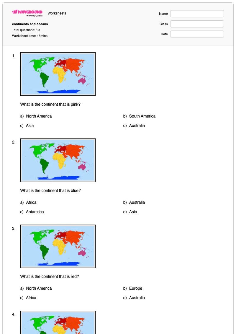
แบบฝึกหัดภูมิศาสตร์สำหรับชั้นประถมศึกษาปีที่ 5 นี้ ช่วยให้นักเรียนระบุทวีปทั้งเจ็ดจากคำใบ้ที่ใช้รหัสสี และเชื่อมโยงแต่ละทวีปกับเบาะแสทางภูมิศาสตร์ที่เกี่ยวข้อง แบบฝึกหัดประกอบด้วยคำถามแบบเลือกตอบ 19 ข้อ ทบทวนจำนวนทวีปและมหาสมุทร ระบุทวีปที่เกี่ยวข้องกับทะเลทรายซาฮารา สัตว์ป่าในเขตขั้วโลก ป่าฝน โคอาลา จิงโจ้ และเมืองประวัติศาสตร์ของยุโรป และให้นักเรียนระบุมหาสมุทรที่ตำแหน่งหมายเลข 3 นักเรียนจะสร้างพื้นฐานความรู้ทางภูมิศาสตร์โลกโดยการแยกแยะทวีปออกจากมหาสมุทร และใช้เบาะแสทางกายภาพ สภาพภูมิอากาศ วัฒนธรรม และตำแหน่งที่ตั้งที่สามารถจดจำได้เพื่อเลือกคำตอบที่ถูกต้อง แบบฝึกหัดนี้เหมาะสำหรับการฝึกฝนแบบมีผู้แนะนำ การทบทวนด้วยตนเอง หรือการประเมินความเข้าใจของนักเรียนเกี่ยวกับทวีปและมหาสมุทรอย่างรวดเร็ว เป็นแบบฝึกหัดที่พิมพ์ได้ฟรีพร้อมเฉลย และยังสามารถใช้งานแบบดิจิทัลผ่าน Wayground ได้อีกด้วย

การตั้งค่าแผ่นงาน

ขนาดตัวอักษร

S
M
L
XL
Waygroundแผ่นงาน

continents and oceans

คำถามทั้งหมด: 19

ชื่อ
ระดับ
วันที่
1.
What is the continent that is pink?
a)
North America
b)
South America
c)
Asia
d)
Australia
2.
What is the continent that is blue?
a)
Africa
b)
Australia
c)
Antarctica
d)
Asia
3.
What is the continent that is red?
a)
North America
b)
Europe
c)
Africa
d)
Australia
4.
What is the continent that is dark green?
a)
North America
b)
South America
c)
Europe
d)
Australia
5.
What is the continent that is yellow?
a)
Africa
b)
Australia
c)
Asia
d)
Antarctica
6.
What is the continent that is orange?
a)
Africa
b)
Australia
c)
Antarctica
d)
Asia
7.
What is the continent that is light green?
a)
North America
b)
South America
c)
Africa
d)
Australia
8.
How many continents are there in the world?
a)
4
b)
5
c)
6
d)
7
9.
How many oceans are there in the world?
a)
7
b)
6
c)
5
d)
4
10.
Which continent is home of the Sahara Desert and is considered the hottest?
a)
South America
b)
Europe
c)
Africa
d)
Australia
11.
On this continent, you can find animal species such as penguins, seals and some birds. This is the coldest continent.
a)
North America
b)
Antarctica
c)
South America
d)
Europe
12.
This continent is covered by large rainforests and is the wettest.
a)
North America
b)
Asia
c)
South America
d)
Africa
13.
This is the smallest continent, farthest away from the others where you may find koalas and kangaroos.
a)
Europe
b)
Africa
c)
South America
d)
Australia
14.
This continent contains major historic cities like Paris, London and Rome.
a)
Africa
b)
Europe
c)
Asia
d)
North America
15.
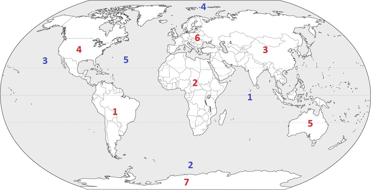
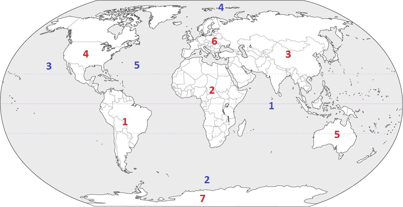
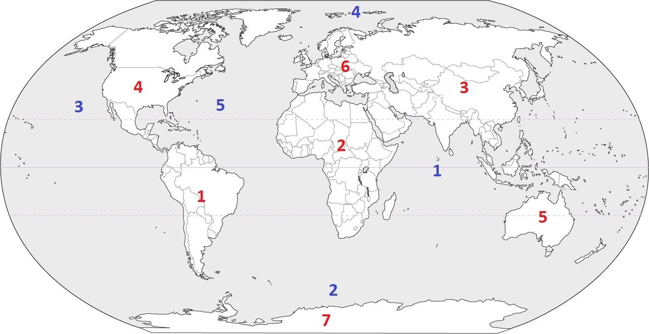
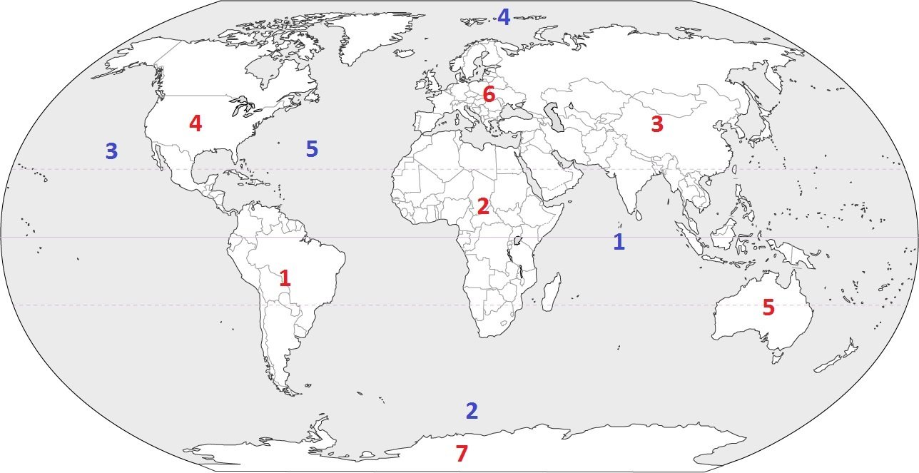
Identify the ocean at location #3
a)
Atlantic Ocean
b)
Arctic Ocean
c)
Pacific Ocean
d)
Indian Ocean
16.
Identify the ocean at location #5
a)
Atlantic Ocean
b)
Southern Ocean
c)
Pacific Ocean
d)
Arctic Ocean
17.
Identify the ocean at location #2
a)
Indian Ocean
b)
Pacific Ocean
c)
Southern Ocean
d)
Arctic Ocean
18.
Identify the ocean at location #1
a)
Southern Ocean
b)
Arctic Ocean
c)
Atlantic Ocean
d)
Indian Ocean
19.
Identify the ocean at location #1
a)
Southern Ocean
b)
Arctic Ocean
c)
Atlantic Ocean
d)
Indian Ocean
Waygroundแป้นคำตอบ

continents and oceans

คำถามทั้งหมด: 19

1.
d) Australia
2.
c) Antarctica
3.
b) Europe
4.
b) South America
5.
a) Africa
6.
d) Asia
7.
a) North America
8.
d) 7
9.
c) 5
10.
c) Africa
11.
b) Antarctica
12.
c) South America
13.
d) Australia
14.
b) Europe
15.
c) Pacific Ocean
16.
a) Atlantic Ocean
17.
c) Southern Ocean
18.
d) Indian Ocean
19.
d) Indian Ocean

คำถามที่พบบ่อย

แบบฝึกหัดเรื่องทวีปและมหาสมุทรครอบคลุมเนื้อหาอะไรบ้าง?

แบบฝึกหัดสำหรับนักเรียนชั้นประถมศึกษาปีที่ 5 นี้ ประกอบด้วยคำถามแบบเลือกตอบ 19 ข้อ เพื่อช่วยเสริมสร้างความรู้ความเข้าใจเกี่ยวกับทวีปทั้งเจ็ดและมหาสมุทรทั้งห้า นักเรียนจะต้องระบุทวีปจากคำใบ้ที่ใช้รหัสสี จับคู่ทวีปกับเบาะแส เช่น ทะเลทรายซาฮารา สัตว์ขั้วโลก ป่าฝน และเมืองสำคัญในยุโรป และระบุชื่อมหาสมุทรที่แสดงอยู่ในตำแหน่งหมายเลข 3

ฉันจะใช้แบบฝึกหัดนี้ในการสอนเรื่องทวีปและมหาสมุทรได้อย่างไร?

เริ่มต้นด้วยการทบทวนทวีปทั้งเจ็ดและมหาสมุทรทั้งห้า จากนั้นให้นักเรียนใช้คำใบ้ที่มีรหัสสีเพื่อระลึกถึงชื่อของแต่ละทวีป ต่อมา ให้นักเรียนอธิบายว่าเบาะแสต่างๆ เช่น สภาพอากาศหนาวเย็นของทวีปแอนตาร์กติกา โคอาลาและจิงโจ้ของออสเตรเลีย หรือทะเลทรายซาฮาราของแอฟริกา สนับสนุนคำตอบของพวกเขาอย่างไร ใช้คำถามเกี่ยวกับมหาสมุทรข้อที่ 3 เพื่อเชื่อมโยงการท่องจำกับการฝึกอ่านแผนที่

ฉันควรสังเกตข้อผิดพลาดอะไรบ้างเมื่อนักเรียนทำแบบฝึกหัดนี้เสร็จ?

นักเรียนอาจสับสนทวีปที่มีชื่อหรือตำแหน่งที่ไม่คุ้นเคย โดยเฉพาะยุโรป เอเชีย และแอฟริกา เมื่อตอบคำถามเกี่ยวกับสีและเบาะแสทางภูมิศาสตร์ นอกจากนี้ พวกเขาอาจเลือกมหาสมุทรหกหรือเจ็ดแห่งแทนที่จะเป็นห้าแห่งตามที่แบบฝึกหัดกำหนด หรืออาจสับสนระหว่างมหาสมุทรกับทวีปในข้อที่เกี่ยวกับตำแหน่ง ตรวจสอบว่านักเรียนใช้เบาะแสทั้งหมดหรือไม่ แทนที่จะเลือกคำตอบจากรายละเอียดเพียงอย่างเดียว

ฉันจะมอบหมายและตรวจงานใบงานเรื่องทวีปและมหาสมุทรนี้อย่างไร?

แบบฝึกหัด 19 ข้อนี้มีให้ดาวน์โหลดในรูปแบบไฟล์ PDF ที่สามารถพิมพ์ได้ และเป็นแบบทดสอบดิจิทัลบน Wayground โดยมีเฉลยคำตอบครบถ้วน สำหรับการส่งงานแบบพิมพ์ ครูสามารถสแกนงานของนักเรียนด้วยแอป Wayground for Teachers เพื่อช่วยในการตรวจให้คะแนน นอกจากนี้ รูปแบบที่สามารถพิมพ์ได้ยังช่วยสนับสนุนห้องเรียนที่ต้องการลดเวลาการใช้หน้าจออีกด้วย

ฉันจะปรับแบบฝึกหัดเรื่องทวีปและมหาสมุทรนี้ให้เหมาะสมกับนักเรียนของฉันได้อย่างไร?

ในการตั้งค่าขั้นสูงของแบบฝึกหัด ให้ปรับระยะห่างระหว่างตัวอักษรหรือเลือกขนาดตัวอักษรที่ใหญ่ขึ้นเพื่อให้คำถามเกี่ยวกับการระบุสีและเบาะแสทางภูมิศาสตร์อ่านง่ายขึ้น นอกจากนี้ คุณยังสามารถเปิดใช้งานแบบอักษรที่เหมาะสำหรับผู้ที่มีภาวะดิสเล็กเซีย หรือแปลแบบฝึกหัดเป็นภาษาอื่นโดยคงรูปแบบคำถามแบบเลือกตอบไว้ได้

ฉันจะหาแบบฝึกหัดแบบนี้เพิ่มเติมได้ที่ไหนบน Wayground?

Wayground มีแบบฝึกหัดและโจทย์ฝึกหัดมากมายให้ดาวน์โหลดฟรีในหลากหลายวิชา พร้อมไฟล์ PDF และเฉลยคำตอบ เพื่อช่วยเสริมสร้างทักษะและความเข้าใจในเนื้อหาสำคัญ ดูแหล่งข้อมูลเพิ่มเติมได้ที่ https://wayground.com/en-us/worksheets