

 แผ่นงาน
Factors that Influence Climate
คำถามทั้งหมด: 20
Prevailing (a) carry warm, moist air over land.
A (a) is a small area with climate conditions that differ from those around them.
The presence of (a) in the path of prevailing winds can influence where precipitation falls.
Earth's surface is divided into three geographical zones based on (a) .

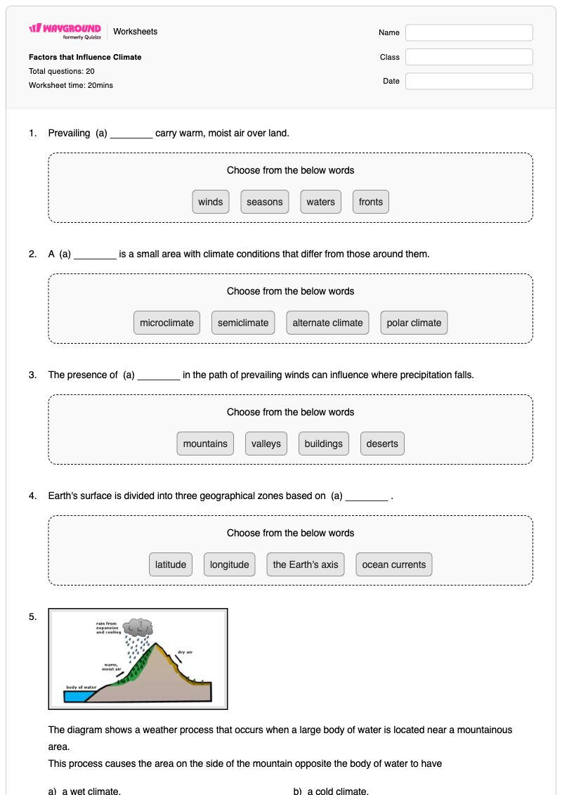
The diagram shows a weather process that occurs when a large body of water is located near a mountainous area.
This process causes the area on the side of the mountain opposite the body of water to have
a wet climate.
a cold climate.
an icy climate.
a dry climate.
If an area has a very cold climate, it is most likely that the area
is close to the equator.
will support tropical plants.
does not get much sunlight.
is close to the ocean.
Some coastal regions of the world have cooler summers and warmer winters than inland regions at the same latitude. What accounts for this difference in climates?
Coastal areas receive more sunlight.
Coastal areas are always flat.
Prevailing winds moderate the weather.
The ocean moderates air temperatures.
A city along the coast of the Atlantic Ocean experiences a seasonal high of 76°F in the summer. The city experiences a seasonal low of 23°F in the winter.
Another city is 60 miles inland and at the same latitude and elevation. This city will probably experience (a) summer highs and (b) winter lows.
The parts of the Earth near the equator receive more sunlight than the north or south poles.
How does this impact the climate at the equator?
It makes the climate warmer.
It makes the climate rainy.
It makes the climate dry.
It makes the climate cooler.
The fact that water heats and cools more slowly than land causes many different types of weather.
What is the primary source of heat for land and water?
energy from the Sun
energy from electricity
heat from friction in the air
heat from inside the Earth
The equator tends to contain regions with hot climates. However, the Rwenzori Mountains, which are located close to the equator, are covered in ice caps.
Why is the climate of the Rwenzori Mountains not hot?
Regions away from the ocean are cooler.
Clouds form a cold blanket over the mountains.
The mountains block radiation from the Sun.
Temperatures decrease with elevation.
In which of the following ways can mountains influence climate?
Mountains have a higher elevation than surrounding areas. Because these areas are closer to the sun, they enjoy a warmer climate.
Mountains have no affect on the climate of an area.
Mountains cause air to rise. The rising air cools, resulting in condensation and precipitation.
Mountains interfere with moving air. The air moves up the mountain, and circles back down, eventually causing tornadoes.
Which of the following best explains why the latitude of a region influences its climate?
The latitude of a region determines its proximity to the ocean.
The latitude of a region determines the land forms present in the area.
The latitude of a region determines how much sunlight the area receives.
The latitude of a region determines its elevation above sea level.

The Sierra Nevada mountain range is located primarily in California. Warm, moist air from the Pacific Ocean travels up the western side of the mountain range, causing precipitation, and drying out as it reaches the top of the mountains.
As the dry air comes down the eastern side of the mountain range, it causes a rain shadow. The Great Basin region of Nevada is located in this rain shadow. How does this affect the climate of the Great Basin region of Nevada?
The rain shadow effect causes the Great Basin region to have very cold winters.
The rain shadow effect causes frequent flooding in the Great Basin region.
The rain shadow effect causes frequent tornadoes in the Great Basin region.
The rain shadow effect causes the Great Basin region to have a very dry climate.
Regions at different latitudes around the world receive different amounts of solar radiation. Polar regions receive the least amount of solar radiation, while the equator receives the most.
How does this most likely affect the global climate?
The global climate is mostly cold.
The global climate is mostly warm.
Polar regions experience colder climates.
Equatorial regions experience colder climates.
The condition of the atmosphere at a certain time and place is called (a)
Long-term patterns of weather in any part of the world is referred to as (a)
What geographical zone do we live in here in South Dakota?
Polar zone
Temperate zone
Tropical zone
End zone
In India, they have seasonal winds called monsoons that affect...
temperature
precipitation
density
happiness
If you live near the ocean, in a marine climate like Astoria, what kind of winters would you expect?
Harsh, extreme winters
Mild winters
No winters at the beach.
Winters with no precipitation
แป้นคำตอบFactors that Influence Climate
คำถามทั้งหมด: 20
a dry climate.
does not get much sunlight.
The ocean moderates air temperatures.
It makes the climate warmer.
energy from the Sun
Temperatures decrease with elevation.
Mountains cause air to rise. The rising air cools, resulting in condensation and precipitation.
The latitude of a region determines how much sunlight the area receives.
The rain shadow effect causes the Great Basin region to have a very dry climate.
Polar regions experience colder climates.
Temperate zone
precipitation
Mild winters