

Wayground
Caribbean South America - Printable สังคมศึกษา Worksheets 8th ระดับชั้น - Wayground

Caribbean South America

Lauren Obaugh

สร้างโดย Lauren Obaugh

20 คำถาม

8th ระดับชั้น

สังคมศึกษา

อัปเดตแล้ว ก.ย. 2569

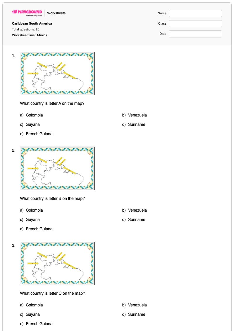
แบบฝึกหัดวิชาสังคมศึกษา ชั้น ม.2 เรื่อง แคริบเบียน อเมริกาใต้ เป็นแบบฝึกหัดที่สามารถพิมพ์ได้ฟรี ช่วยพัฒนาทักษะการอ่านแผนที่และภูมิศาสตร์ระดับภูมิภาค นักเรียนจะได้ระบุประเทศต่างๆ ในแคริบเบียน อเมริกาใต้ จากตำแหน่งที่ระบุไว้บนแผนที่ เชื่อมโยงชื่อประเทศกับเมืองหลวง ระบุความสัมพันธ์ของเส้นศูนย์สูตรกับประเทศโคลอมเบีย และจดจำลักษณะทางภูมิศาสตร์ที่สำคัญที่แสดงบนแผนที่ แบบฝึกหัดนี้มีทั้งหมด 20 ข้อ ประกอบด้วยคำถามแบบเลือกตอบ 18 ข้อ คำถามจับคู่ 1 ข้อ และกิจกรรมจำแนกประเภท 1 ข้อ แบบฝึกหัดนี้ช่วยให้นักเรียนแยกแยะความแตกต่างระหว่างภูมิศาสตร์การเมืองและภูมิศาสตร์กายภาพ โดยใช้หลักฐานจากแผนที่เพื่อระบุตำแหน่งและความสัมพันธ์ เหมาะสำหรับใช้ในการแนะนำหรือทบทวนประเทศ เมืองหลวง ละติจูด และลักษณะทางภูมิศาสตร์ของภูมิภาคในชั้นเรียน ใช้เป็นแบบฝึกหัดอิสระ หรือใช้เป็นการประเมินผลอย่างรวดเร็ว แบบฝึกหัดนี้มีให้ดาวน์โหลดเป็นไฟล์ PDF ฟรี และมีเฉลยคำตอบครบถ้วนเพื่อการตรวจสอบและให้ข้อเสนอแนะอย่างมีประสิทธิภาพ

การตั้งค่าแผ่นงาน

ขนาดตัวอักษร

S
M
L
XL
Waygroundแผ่นงาน

Caribbean South America

คำถามทั้งหมด: 20

ชื่อ
ระดับ
วันที่
1.
What country is letter A on the map?

What country is letter A on the map?

a)

Colombia

b)

Venezuela

c)

Guyana

d)

Suriname

e)

French Guiana

2.
What country is letter B on the map?

What country is letter B on the map?

a)

Colombia

b)

Venezuela

c)

Guyana

d)

Suriname

e)

French Guiana

3.
What country is letter C on the map?

What country is letter C on the map?

a)

Colombia

b)

Venezuela

c)

Guyana

d)

Suriname

e)

French Guiana

4.
What country is letter D on the map?

What country is letter D on the map?

a)

Colombia

b)

Venezuela

c)

Guyana

d)

Suriname

e)

French Guiana

5.
What country is letter E on the map?

What country is letter E on the map?

a)

Colombia

b)

Venezuela

c)

Guyana

d)

Suriname

e)

French Guiana

6.
What capital is located at Letter A

What capital is located at Letter A

a)

Bogota

b)

Caracas

c)

Georgetown

d)

Paramaribo

e)

Cayenne

7.
What capital is located at Letter B

What capital is located at Letter B

a)

Bogota

b)

Caracas

c)

Georgetown

d)

Paramaribo

e)

Cayenne

8.
What capital is located at Letter C

What capital is located at Letter C

a)

Bogota

b)

Caracas

c)

Georgetown

d)

Paramaribo

e)

Cayenne

9.
What capital is located at Letter D

What capital is located at Letter D

a)

Bogota

b)

Caracas

c)

Georgetown

d)

Paramaribo

e)

Cayenne

10.
What capital is located at Letter E

What capital is located at Letter E

a)

Bogota

b)

Caracas

c)

Georgetown

d)

Paramaribo

e)

Cayenne

11.
What major line of latitude runs through Colombia in South America?

What major line of latitude runs through Colombia in South America?

a)

Tropic of Cancer

b)

Equator

c)

Tropic of Capricorn

d)

Prime Meridian

12.
What geographic feature is found at Letter A on the map

What geographic feature is found at Letter A on the map

a)

Pacific Ocean

b)

Andes Mountains

c)

Caribbean Sea

d)

Orinoco River

e)

Atlantic Ocean

13.
What geographic feature is found at Letter B on the map

What geographic feature is found at Letter B on the map

a)

Pacific Ocean

b)

Andes Mountains

c)

Caribbean Sea

d)

Orinoco River

e)

Atlantic Ocean

14.
What geographic feature is found at Letter C on the map

What geographic feature is found at Letter C on the map

a)

Pacific Ocean

b)

Andes Mountains

c)

Caribbean Sea

d)

Orinoco River

e)

Atlantic Ocean

15.
What geographic feature is found at Letter D on the map

What geographic feature is found at Letter D on the map

a)

Pacific Ocean

b)

Andes Mountains

c)

Caribbean Sea

d)

Orinoco River

e)

Atlantic Ocean

16.
What geographic feature is found at Letter E on the map

What geographic feature is found at Letter E on the map

a)

Pacific Ocean

b)

Andes Mountains

c)

Caribbean Sea

d)

Orinoco River

e)

Atlantic Ocean

17.

Match the following places with the correct description

Llanos

grassland found in South America

Tepuis

sandstone resistant to erosion

Andes Mountains

longest mountain system in the world

Angels Falls

world's highest waterfall

18.

Organize these facts between Climate and Resources

จัดหมวดหมู่ดังต่อไปนี้

located near equator impacts temperatures

lots of rain and vegetation due to location

height of elevation impacts it

rice, coffee, sugarcane, and bananas

oil

timber

Climate
Resources
19.
What country is EAST of Suriname on the map?

What country is EAST of Suriname on the map?

a)

Colombia

b)

Venezuela

c)

Guyana

d)

French Guiana

20.
What country is WEST of Venezuela on the map?

What country is WEST of Venezuela on the map?

a)

Colombia

b)

Venezuela

c)

Guyana

d)

French Guiana

Waygroundแป้นคำตอบ

Caribbean South America

คำถามทั้งหมด: 20

1.
a)

Colombia

2.
c)

Guyana

3.
e)

French Guiana

4.
d)

Suriname

5.
b)

Venezuela

6.
c)

Georgetown

7.
a)

Bogota

8.
b)

Caracas

9.
e)

Cayenne

10.
d)

Paramaribo

11.
b)

Equator

12.
b)

Andes Mountains

13.
c)

Caribbean Sea

14.
a)

Pacific Ocean

15.
e)

Atlantic Ocean

16.
d)

Orinoco River

17.

Llanos

 - 

grassland found in South America

, 

Tepuis

 - 

sandstone resistant to erosion

, 

Andes Mountains

 - 

longest mountain system in the world

, 

Angels Falls

 - 

world's highest waterfall

18.
Climate

located near equator impacts temperatures

lots of rain and vegetation due to location

height of elevation impacts it

Resources

rice, coffee, sugarcane, and bananas

oil

timber

19.
d)

French Guiana

20.
a)

Colombia

คำถามที่พบบ่อย

แบบฝึกหัดเกี่ยวกับแคริบเบียนและอเมริกาใต้ครอบคลุมเนื้อหาอะไรบ้าง?

แบบฝึกหัดวิชาสังคมศึกษา ชั้น ม.2 นี้ ใช้คำถามบนแผนที่พร้อมป้ายกำกับ เพื่อประเมินความสามารถของนักเรียนในการระบุประเทศในแถบแคริบเบียนและอเมริกาใต้ เชื่อมโยงตำแหน่งบนแผนที่กับเมืองหลวง รับรู้ความสัมพันธ์ของเส้นศูนย์สูตรกับประเทศโคลอมเบีย และระบุลักษณะทางภูมิศาสตร์ แบบฝึกหัดนี้มีทั้งหมด 20 ข้อ ประกอบด้วยคำถามแบบเลือกตอบ 18 ข้อ กิจกรรมจับคู่ 1 กิจกรรม และกิจกรรมจัดกลุ่ม 1 กิจกรรม ซึ่งต้องให้นักเรียนตีความป้ายกำกับบนแผนที่และจัดเรียงข้อมูลทางภูมิศาสตร์

ฉันจะใช้แบบฝึกหัดนี้ในการสอนภูมิศาสตร์เกี่ยวกับแคริบเบียนและอเมริกาใต้ได้อย่างไร?

เริ่มใช้แบบฝึกหัดโดยให้นักเรียนแยกข้อมูลบนแผนที่ออกเป็นภูมิศาสตร์การเมือง—ประเทศและเมืองหลวง—และภูมิศาสตร์กายภาพ รวมถึงละติจูดและลักษณะภูมิประเทศหรือแหล่งน้ำ ทำกิจกรรมที่ระบุชื่อสถานที่บนแผนที่ร่วมกันสักสองสามข้อ โดยขอให้นักเรียนอธิบายว่าตำแหน่งบนแผนที่สนับสนุนคำตอบแต่ละข้ออย่างไร จากนั้นจึงมอบแบบฝึกหัดที่เหลือซึ่งเป็นแบบเลือกตอบ จับคู่ และจำแนกประเภท ให้นักเรียนทำด้วยตนเองหรือภายใต้การแนะนำ ทบทวนข้อผิดพลาดโดยขอให้นักเรียนเปรียบเทียบประเทศ เมืองหลวง และลักษณะภูมิประเทศที่อยู่ใกล้เคียง แทนที่จะท่องจำชื่อที่แยกจากกัน

ฉันควรระวังข้อผิดพลาดอะไรบ้างเมื่อนักเรียนทำแบบฝึกหัดเกี่ยวกับภูมิภาคแคริบเบียนและอเมริกาใต้ชุดนี้?

นักเรียนอาจสับสนระหว่างข้อที่ระบุประเทศกับข้อที่ระบุเมืองหลวง เนื่องจากทั้งสองข้อใช้ตำแหน่งบนแผนที่ที่มีตัวอักษรและตัวเลือกคำตอบที่ซ้ำซ้อนกัน นอกจากนี้ พวกเขาอาจเลือกประเทศหรือเมืองหลวงที่อยู่ใกล้เคียงโดยไม่ได้ตรวจสอบตำแหน่งของป้ายกำกับ หรือสับสนระหว่างเส้นละติจูดกับลักษณะทางภูมิศาสตร์เมื่อตอบคำถามเกี่ยวกับเส้นศูนย์สูตร ในระหว่างการทบทวน ให้นักเรียนอธิบายว่าคำตอบแต่ละข้อระบุชื่อประเทศ เมืองหลวง เส้นละติจูด หรือลักษณะทางภูมิศาสตร์ และตรวจสอบว่าตัวเลือกการจับคู่และการจัดประเภทของพวกเขาเป็นไปตามหมวดหมู่เดียวกัน

ฉันจะมอบหมายและให้คะแนนแบบฝึกหัดเกี่ยวกับภูมิภาคแคริบเบียนและอเมริกาใต้ได้อย่างไร?

Wayground จัดเตรียมแบบฝึกหัดนี้ในรูปแบบไฟล์ PDF ที่สามารถพิมพ์ได้ และแบบทดสอบดิจิทัล พร้อมเฉลยคำตอบครบถ้วนสำหรับทั้ง 20 ข้อ สามารถมอบหมายแบบทดสอบดิจิทัลสำหรับการตอบคำถามออนไลน์ หรือพิมพ์แบบฝึกหัดบนแผนที่เพื่อฝึกฝนบนกระดาษ การส่งงานในรูปแบบไฟล์พิมพ์สามารถตรวจได้โดยการสแกนงานของนักเรียนด้วยแอป Wayground for Teachers รูปแบบไฟล์พิมพ์ยังช่วยสนับสนุนโรงเรียนที่ต้องการลดเวลาการใช้หน้าจอได้อีกด้วย

ฉันจะปรับแบบฝึกหัดเกี่ยวกับภูมิภาคแคริบเบียนและอเมริกาใต้ให้เหมาะสมกับนักเรียนของฉันได้อย่างไร?

ใช้การตั้งค่าขั้นสูงของแบบฝึกหัดเพื่อปรับระยะห่างระหว่างตัวอักษรและขนาดตัวอักษร เพื่อให้คำถามเกี่ยวกับแผนที่ที่มีป้ายกำกับ ตัวเลือกคำตอบ การจับคู่ และกิจกรรมการจำแนกประเภทอ่านง่ายขึ้น นอกจากนี้ คุณยังสามารถเปิดใช้งานแบบอักษรที่เหมาะสำหรับผู้ที่มีภาวะดิสเล็กเซีย หรือแปลแบบฝึกหัดเป็นภาษาอื่นได้ เมื่อตัวเลือกเหล่านั้นช่วยให้เข้าถึงคำศัพท์ทางภูมิศาสตร์และทิศทางได้ง่ายขึ้น โปรดคงป้ายกำกับแผนที่และหมวดหมู่คำตอบไว้ให้มองเห็นได้ขณะปรับรูปแบบแบบฝึกหัด

ฉันจะหาแบบฝึกหัดแบบนี้เพิ่มเติมได้ที่ไหนบน Wayground?

Wayground มีแบบฝึกหัดและโจทย์ฝึกหัดมากมายให้ดาวน์โหลดฟรีในหลากหลายวิชา พร้อมไฟล์ PDF และเฉลยคำตอบ เพื่อช่วยให้นักเรียนพัฒนาทักษะและความเข้าใจในแนวคิดสำคัญๆ ดูแหล่งข้อมูลเพิ่มเติมได้ที่ https://wayground.com/en-us/worksheets