

Wayground
Unit 2: Weathering, Erosion, Deposition, and Landforms - Printable พลศึกษา Worksheets ระดับ 6 - Wayground

Unit 2: Weathering, Erosion, Deposition, and Landforms

Jamie Gomez

สร้างโดย Jamie Gomez

14 คำถาม

6th ระดับชั้น

พลศึกษา

อัปเดตแล้ว ก.พ. 2569

แบบฝึกหัดวิทยาศาสตร์สำหรับนักเรียนชั้นประถมศึกษาปีที่ 6 นี้ ช่วยให้นักเรียนแยกแยะความแตกต่างระหว่างการผุพังทางกายภาพและทางเคมี และเชื่อมโยงกระบวนการแต่ละอย่างกับสาเหตุต่างๆ เช่น การกัดเซาะ สิ่งมีชีวิต ออกซิเจน และกรดในน้ำบาดาล นักเรียนยังจะได้ฝึกคิดเกี่ยวกับวิธีการที่ลมและน้ำเคลื่อนย้ายและสะสมตะกอน รวมถึงเหตุผลที่อนุภาคหนักกว่าตกตะกอนก่อน และการเกิดของลักษณะภูมิประเทศต่างๆ เช่น พัดตะกอน ดินดอนสามเหลี่ยมปากแม่น้ำ เนินทราย ดินเลสส์ หลุมยุบ และธารน้ำแข็ง แบบฝึกหัดประกอบด้วย 14 ข้อ แบ่งเป็นคำถามแบบเลือกตอบ 12 ข้อ และคำถามแบบเลือกคำตอบ 2 ข้อ นักเรียนจะได้ตีความแผนภาพและรูปภาพ ระบุลักษณะภูมิประเทศ เปรียบเทียบกระบวนการผุพัง จดจำรูปแบบการสะสม และประยุกต์ใช้คำศัพท์กับตัวอย่างต่างๆ เช่น ความลาดชันของเนินทรายและการถล่มของถ้ำ แบบฝึกหัดนี้เหมาะสำหรับการทบทวนวิทยาศาสตร์โลก การฝึกฝนด้วยตนเอง หรือการตรวจสอบความเข้าใจหลังการเรียนการสอน แบบฝึกหัดนี้มีให้ดาวน์โหลดเป็นไฟล์ PDF ฟรี และมีเฉลยคำตอบครบถ้วนเพื่อการตรวจสอบที่มีประสิทธิภาพ

การตั้งค่าแผ่นงาน

ขนาดตัวอักษร

S
M
L
XL
Waygroundแผ่นงาน

Unit 2: Weathering, Erosion, Deposition, and Landforms

คำถามทั้งหมด: 14

ชื่อ
ระดับ
วันที่
1.

What are the two ways that rocks are broken down into smaller pieces?

a)

chemical weathering and physical weathering

b)

physical weathering and precipitation

c)

chemical weathering and dissolving

d)

abrasion and erosion

2.

What is the difference between chemical and physical weathering?

a)

they both the same

b)

physcial changes the composition of rocks and chemical does not

c)

chemical changes the composition of rocks and physical breaks them down into smaller pieces

d)

physical changes the composition of rocks and chemical breaks them down into smaller pieces

e)

physical breaks down rocks and chemical does too

3.

Wind picks up sediment from the ground and carries it aloft. As the wind slows, it deposits the sediment in other places, sometimes forming dunes. Which type of sediment will be dropped and deposited first as the wind slows?

a)

the biggest

b)

the lightest

c)

the smallest

d)

the heaviest

4.
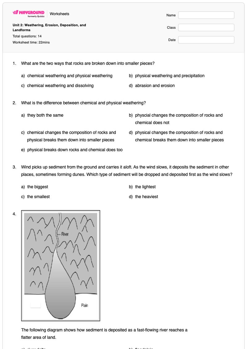
The following diagram shows how sediment is deposited as a fast-flowing river reaches a flatter area of land.

The following diagram shows how sediment is deposited as a fast-flowing river reaches a

flatter area of land.

a)

river delta

b)

floodplain

c)

alluvial fan

d)

oxbow lake

e)

beach

5.

What are some ways that animals contriute to physical weathering? Must choose all correct answers.

a)

animals borrow causing abrasion

b)

animal movememnt exposes rocks to wind and water

c)

animals release acids that change the chemical composition of rocks

d)

animal casue acid precipitation

6.

What living organisms contribute to physical weathering?

a)

Plants

b)

animals

c)

plants and animals

d)

neither

7.

Which is the steepest side of a dune?

a)

the slip face

b)

the side facing the ocean

c)

the side facing away from the ocean

d)

the windward face

8.
The roof of a cave eroded and became thinner over time. The roof then collapsed and the landform shown in the figure was…

The roof of a cave eroded and became thinner over time. The roof then collapsed and the landform shown in the figure was formed.

a)

canyon

b)

delta

c)

cavern

d)

sinkhole

e)

glacier

9.

What formation results when a river deposits sediment and it slows down as it enters a large body of water?

a)

dune

b)

alluvial fan

c)

delta

d)

bay

e)

floodplain

10.

Which is a cause of chemical weathering? Chose all that apply.

a)

oxygen and acids in living things

b)

gravity

c)

ice and wind

d)

wind

e)

acids in groundwater

11.
What is the largest lake in Florida? Use the diagram.

What is the largest lake in Florida? Use the diagram.

a)

Lake Apopka

b)

Lake Istokpoga

c)

Lake Kissimmee

d)

Lake Okeechobee

12.
What is the landform show in the image?

What is the landform show in the image?

a)

alpine glacier

b)

glacial drift

c)

glacial cirque

d)

continental glacier

13.

Besides forming sand dunes, wind also changes the soil over large regions of Earth by depositing dust. What kind of landform is produced by deposits of fine, wind-blown sediment?

a)

creep

b)

dune

c)

glacier

d)

loess

e)

desert concrete

14.
What is the landform show in the image?

What is the landform show in the image?

a)

alpine glacier

b)

glacial drift

c)

glacial cirque

d)

continental glacier

Waygroundแป้นคำตอบ

Unit 2: Weathering, Erosion, Deposition, and Landforms

คำถามทั้งหมด: 14

1.
a)

chemical weathering and physical weathering

2.
c)

chemical changes the composition of rocks and physical breaks them down into smaller pieces

3.
d)

the heaviest

4.
c)

alluvial fan

5.
a)

animals borrow causing abrasion

, b)

animal movememnt exposes rocks to wind and water

6.
c)

plants and animals

7.
a)

the slip face

8.
d)

sinkhole

9.
c)

delta

10.
a)

oxygen and acids in living things

, e)

acids in groundwater

11.
d)

Lake Okeechobee

12.
a)

alpine glacier

13.
d)

loess

14.
a)

alpine glacier

คำถามที่พบบ่อย

แบบฝึกหัดเรื่องการผุกร่อน การกัดเซาะ และการสะสมตะกอนนี้ ช่วยให้นักเรียนชั้นประถมศึกษาปีที่ 6 เรียนรู้อะไรบ้าง?

แบบฝึกหัดวิทยาศาสตร์ชั้นประถมศึกษาปีที่ 6 ชุดนี้มี 14 ข้อ ช่วยเสริมสร้างความสามารถของนักเรียนในการแยกแยะความแตกต่างระหว่างการผุพังทางกายภาพ ซึ่งทำให้หินแตกเป็นชิ้นเล็กๆ กับการผุพังทางเคมี ซึ่งเปลี่ยนแปลงองค์ประกอบของหิน แบบฝึกหัดนี้ยังมีทั้งแบบเลือกตอบและเลือกคำตอบที่ถูกต้อง และยังช่วยให้นักเรียนระบุสาเหตุของการผุพัง อธิบายว่าลมและน้ำพัดพาตะกอนมาได้อย่างไร และใช้แผนภาพหรือรูปภาพเพื่อจำแนกลักษณะภูมิประเทศ เช่น พัดตะกอน ดินดอนสามเหลี่ยมปากแม่น้ำ หลุมยุบ ดินเลส และธารน้ำแข็ง

ฉันจะใช้แบบฝึกหัดนี้ในการสอนเรื่องการผุพัง การกัดเซาะ การสะสมตัว และลักษณะภูมิประเทศได้อย่างไร?

เริ่มด้วยการให้นักเรียนจัดเรียงตัวอย่างออกเป็น การผุพังทางกายภาพ การผุพังทางเคมี การกัดเซาะ และการสะสมตัว จากนั้นใช้คำถามที่อิงจากแผนภาพและรูปภาพเพื่ออธิบายว่าทำไมตะกอนที่มีน้ำหนักมากจึงสะสมตัวก่อน วิธีที่แม่น้ำก่อให้เกิดพัดตะกอนหรือดินดอนสามเหลี่ยมปากแม่น้ำ และวิธีการระบุลักษณะภูมิประเทศ เช่น เนินทราย หลุมยุบ และธารน้ำแข็ง ทบทวนคำถามแบบเลือกตอบสองข้อร่วมกัน เพื่อให้นักเรียนอธิบายว่าเหตุใดสาเหตุที่เลือกแต่ละข้อจึงอยู่ในกระบวนการนั้น

ฉันควรสังเกตข้อผิดพลาดอะไรบ้างเมื่อนักเรียนทำแบบฝึกหัดนี้เสร็จ?

ระวังนักเรียนที่สับสนระหว่างการผุพังทางกายภาพและการผุพังทางเคมี โดยเฉพาะอย่างยิ่งการมองว่าการเปลี่ยนแปลงองค์ประกอบของหินเป็นการผุพังทางกายภาพ พวกเขาอาจสับสนระหว่างพัดตะกอนกับดินดอนสามเหลี่ยมปากแม่น้ำ เลือกด้านรับลมแทนที่จะเป็นด้านลื่นของเนินทราย หรือเลือกตัวเลือกที่เป็นไปได้ทุกข้อในคำถามแบบเลือกตอบโดยไม่ตรวจสอบว่าตัวเลือกนั้นก่อให้เกิดการผุพังทางกายภาพหรือทางเคมีกันแน่ นอกจากนี้ รูปภาพและแผนภาพอาจแสดงให้เห็นถึงความสับสนระหว่างธารน้ำแข็งบนเทือกเขาแอลป์ ลักษณะทางธรณีวิทยาที่เกิดจากธารน้ำแข็ง หลุมยุบ และลักษณะภูมิประเทศอื่นๆ

ฉันจะมอบหมายและให้คะแนนแบบฝึกหัดเรื่องการผุกร่อนและลักษณะภูมิประเทศนี้ได้อย่างไร?

บน Wayground คุณสามารถกำหนดให้เป็นไฟล์ PDF ที่พิมพ์ได้ หรือเป็นแบบทดสอบดิจิทัล และใช้เฉลยคำตอบที่สมบูรณ์เพื่อตรวจสอบคำตอบแบบเลือกตอบ 12 ข้อ และคำตอบแบบเลือกหลายข้อ 2 ข้อ การส่งงานแบบพิมพ์ได้ยังสามารถตรวจได้โดยการสแกนงานของนักเรียนด้วยแอป Wayground for Teachers รูปแบบที่พิมพ์ได้นี้ยังช่วยสนับสนุนโรงเรียนที่กำลังลดเวลาการใช้หน้าจอได้อีกด้วย

ฉันจะปรับแบบฝึกหัดเรื่องการผุกร่อนและลักษณะภูมิประเทศนี้ให้เหมาะสมกับนักเรียนของฉันได้อย่างไร?

ใช้การตั้งค่าขั้นสูงของแบบฝึกหัดเพื่อปรับระยะห่างระหว่างตัวอักษรและขนาดตัวอักษร เพื่อให้คำจำกัดความของการผุกร่อน ตัวเลือกลักษณะภูมิประเทศ และคำแนะนำตามแผนภาพอ่านง่ายขึ้น นอกจากนี้ คุณยังสามารถเปิดใช้งานแบบอักษรที่เหมาะสำหรับผู้ที่มีภาวะดิสเล็กเซีย หรือแปลแบบฝึกหัดเป็นภาษาอื่นโดยยังคงรูปแบบคำถามแบบเลือกตอบและเลือกหลายข้อเอาไว้ได้

ฉันจะหาแบบฝึกหัดฟรีแบบนี้เพิ่มเติมได้ที่ไหนบน Wayground?

Wayground มีแบบฝึกหัดและโจทย์ฝึกหัดมากมายให้ดาวน์โหลดฟรีในหลากหลายวิชา พร้อมไฟล์ PDF และเฉลยคำตอบ เพื่อช่วยให้นักเรียนพัฒนาทักษะและความเข้าใจในแนวคิดสำคัญๆ ดูแหล่งข้อมูลเพิ่มเติมได้ที่ https://wayground.com/en-us/worksheets