
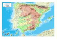
España y Europa. Mapa físico

Flashcard
•
Geography
•
6th Grade
•
Practice Problem
•
Hard

REBECA DE LA SIERRA
FREE Resource
Student preview

10 questions
Show all answers
1.
FLASHCARD QUESTION
Front
¿Qué es un sistema montañoso?
Back
Conjunto de montañas que se considera como una unidad
2.
FLASHCARD QUESTION
Front
¿Cómo se llama el sistema montañoso que separa España de Francia?
Back
Pirineos
3.
FLASHCARD QUESTION
Front
¿Cuál es el sistema montañoso marcado en rojo?

Back
Macizo Galaico
4.
FLASHCARD QUESTION
Front
Imagina que te encuentras en las Islas Canarias, ¿Cuál de los siguientes picos se encuentra en una de sus islas?
Back
Teide
5.
FLASHCARD QUESTION
Front
Es un río de la vertiente mediterránea.
Back
Ter
6.
FLASHCARD QUESTION
Front
La imagen señala...

Back
Mar Menor
7.
FLASHCARD QUESTION
Front
La imagen señala...

Back
Golfo de Cádiz

Access all questions and much more by creating a free account
Create resources
Host any resource
Get auto-graded reports

Continue with Google

Continue with Email

Continue with Microsoft
or continue with

%20(1).png)
Apple

Others
Already have an account?


