
MOUNTAINS, HILL & MAPS
Presentation
•
Geography
•
6th Grade
•
Practice Problem
•
Medium

Irene Odame
Used 30+ times
FREE Resource
12 Slides • 7 Questions
1
MOUNTAINS, HILL & MAPS

2
Mountains and Hills are areas of high ground.
A Mountain is an area of high ground that rises 300 metres above sea level.
While a Hill is an area of high ground that is less than 300 metres above sea level
3
Examples of mountains include Mount Everest in Nepal which is the highest mountain in the world, Mount Kilimanjaro in Tanzania the highest mountain in Africa, Mountain Afadzato in Ghana, Mount Fuji in Japan, Ben Nevis in Scotland, Aconcagua Mountain in Argentina.
Examples of Hills include Cypress Hill, Signal Hill in Cape Town and Shai Hills in Ghana.
4
Multiple Choice
If the ground rises more than 300 metres above sea level it is called a
Hill
Mountain
5
Open Ended
Mention any two mountains that you know.
6
A map is almost essential when walking up on a mountain, but a map is flat so how do we show mountains, hills and other land forms on a map.
There are two main ways of showing these features on maps.
7
TYPES OF MAPS
There are two main types of maps used to show mountains and hills these are: Topographic Maps and Relief Maps
Topographic Maps show the natural features of the land such a hills mountains, lakes and rivers as well as things that are made by people such as roads and towns.
A Relief Map shows only how high or low the different parts of a region, country or continents are.
8
The height of the land is shown by using different colours usually shades of brown and green. All land areas of the same level are given the same colour therefore such a map needs a key.
When we say Mount Everest is 8863 metres high, we mean that its height is 8863 metres above sea level.
9

A Topographic map of Nigeria showing lakes, rivers mountains and hills. ( Obodu Mountain)
10

A Relief Map of North and West Africa.
11
Fill in the Blanks
Type answer...
12
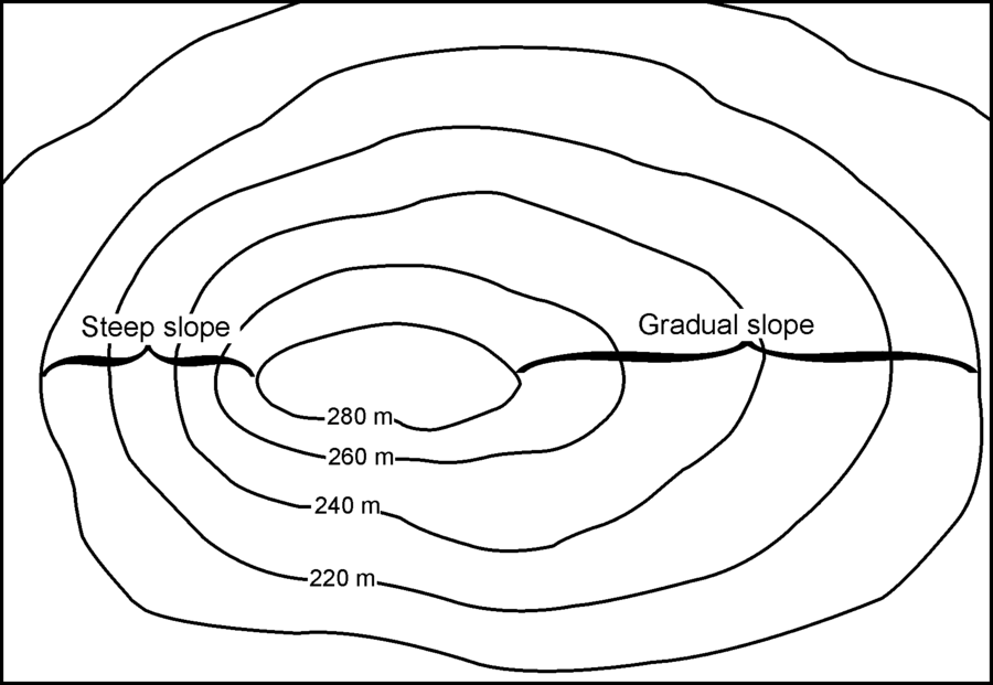
Contour Lines
Another way of showing mountains and hills on a map is by using contour lines.
Contour lines are lines joining places of equal heights above sea level.
Note: They are exactly the same, they do not cross each other. Contour lines make it possible to show the height and shape of mountains, the depths of the ocean bottom, and the steepness of slopes.
13
Contour Line Showing a hill because it is less than 300m above sea level.
14
Multiple Select
Contour lines are lines that join places of equal heights above sea level.
True
False
15
Multiple Choice

This Contour line shows a .....
Hill
Map
Mountain
16
Multiple Choice
If contour lines are close together, then the slope is ....
Gentle
Flat
Steep
17
Importance of Mountains and Highlands
Minerals: Mountains and highlands often contain minerals like gold, diamond, bauxite and manganese. Countries mine these minerals and sell them for foreign exchange which is used to develop the country.
Rocks for Construction: Mountains often contain rocks or stones that can be quarried and used for the construction of roads, bridges, dams and buildings. The rocks are also broken down into small chippings which are used for terrazzo designs on buildings.
18
Importance of Mountains and Highlands
Cooler Climates: Mountain tops and highlands have cooler climates and more comfortable weather. This is because the higher you go, the cooler it becomes. In hot climates like Ghana, many people like to live in highland areas
Wind Breaks: Mountains and highlands serve as windbreaks by controlling the movement of the wind. Sometimes, they protect settlements against strong winds which can damage buildings.
19
Open Ended
List Three importance of mountains and highlands.
MOUNTAINS, HILL & MAPS
Show answer
Auto Play
Slide 1 / 19
SLIDE
Similar Resources on Wayground

14 questions
Polygons on the Coordinate Plane
Presentation
•
6th Grade
14 questions
Lesson 7: Analyzing Character Development
Presentation
•
6th Grade
15 questions
tape diagram
Presentation
•
6th Grade
15 questions
Distributive Property
Presentation
•
6th Grade
15 questions
Measures of Center
Presentation
•
6th Grade
15 questions
Solution, Colloid and Suspension
Presentation
•
6th Grade
18 questions
The Silk Road Vocabulary
Presentation
•
6th Grade
14 questions
Q1, Q3, IQR
Presentation
•
6th Grade
Popular Resources on Wayground
11 questions
Hallway & Bathroom Expectations
Quiz
•
6th - 8th Grade
10 questions
HCS SCI 03 Summer School Assessment 2
Quiz
•
3rd Grade
11 questions
Home Scope
Quiz
•
7th - 8th Grade
12 questions
2026 TAP Technology in the Classroom
Presentation
•
Professional Development
15 questions
HCS SCI 05 Summer School Assessment 2 Review
Quiz
•
5th Grade
15 questions
HCS SCI 04 Summer School Review 2
Quiz
•
4th Grade
59 questions
Geometry Unit 3 Review
Quiz
•
9th - 12th Grade
14 questions
FAST ELA READING SMAPLE TEST MATERIALS
Passage
•
3rd Grade