Search Header Logo
Geography Handbook

Geography Handbook

Assessment

Presentation

Geography

7th Grade

Medium

Created by

Harold Smith

Used 31+ times

FREE Resource

7 Slides • 56 Questions

1

Geography Handbook

Geography with Mr. Smith

Slide image

2


Geography is the study of the physical of the Earth and how humans affect the natural world.

3


4

Grid

Geographers use a pattern of imaginary lines that circle the globe in east -west and north-south directions.

5

Multiple Choice

A grid is

1

study of the grass.

2

study of water.

3

study of the patterns of imaginary lines that circle the globe.

4

study of the rivers and lakes that flow through the universe.

6

Slide image

7

https://youtu.be/0z9_t8DMk5k

https://youtu.be/0z9_t8DMk5k

8


9

Multiple Select

Which of these make up the hemisphere?

1

Northern

2

Southern

3

Eastern

4

Western

5

Grid

10

Multiple Choice

______________ are features on Earth's surface that are formed by ______________.

1

Maps, cartographers

2

Lagoons, waterfalls

3

Landforms, nature

4

Hills, mountains

11

Multiple Choice

Shows distances on a map

1

map key

2

ruler

3

map scale

4

latitude

12

Multiple Choice

A type of map that shows landforms and bodies of water

1

climate map

2

physical map

3

resource map

4

political map

13

Multiple Choice

The imaginary line halfway between the North Pole and South Pole.

1

latitude

2

Prime Meridian

3

equator

4

longitude

14

Multiple Choice

Lines that go across a map or around a globe. They run east and west.

1

latitude

2

equator

3

longitude

4

vertical

15

Multiple Choice

A type of map that includes boundaries, cities, and states

1

climate map

2

physical map

3

political map

4

population map

16

Multiple Choice

Lines that go up and down on a map or globe. They run north and south.

1

longitude

2

vertical

3

latitude

4

horizontal

17

Multiple Choice

Separates the Earth into east and west hemispheres

1

longitude

2

equator

3

latitude

4

Prime Meridian

18

Multiple Select

This tells what the symbols on a map stand for

1

map key

2

map scale

3

legend

4

title

19

Multiple Choice

A term that means "half of the Earth"

1

longitude

2

equator

3

latitude

4

hemisphere

20

Multiple Choice

The directions that are midway between two cardinal directions.

1

intermediate directions

2

cardinal directions

3

GPS directions

4

location

21

Multiple Choice

Question image

What is the name of the large body of water between Africa, Asia and Europe?

1

Atlantic Ocean

2

Black Sea

3

Caribbean Sea

4

Mediterranean Sea

22

Multiple Choice

A POLITICAL MAP shows the boundaries between each country. Select the POLITICAL MAP.

1
2

23

Multiple Choice

A PHYSICAL MAP shows what the land looks like in a country. Select the picture of a PHYSICAL MAP.

1
2

24

Multiple Choice

The EQUATOR is an imaginary line around the middle of the Earth?

1

True

2

False

25

Multiple Choice

North, south, east and west are known as the 
1
compass rose
2
cardinal directions
3
map
4
GPS

26

Multiple Choice

Question image
Start at the school and walk home to your neighborhood, which direction are you walking?
1
south
2
north
3
east
4
southwest

27

Multiple Choice

Question image

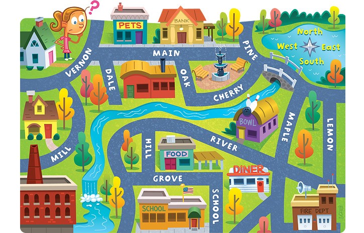
Look at the map what is directly EAST of the barn?
1
the neighborhood
2
the school
3
the forest
4
the airport

28

Multiple Choice

Question image
The star is a symbol for
1
a city
2
the police
3
the road
4
the river

29

Multiple Choice

Question image
Use the map key to answer the questions.  The triangles are a symbol for?
1
Mountains
2
River
3
Railroad
4
River

30

Multiple Choice

Question image
Which color continent is the United States?
1
orange
2
yellow
3
green
4
blue

31

Multiple Choice

Question image
The picture on the right of this map are part of the 
1
map key
2
compass rose
3
cardinal directions
4
a globe

32

Multiple Choice

Question image
What is this a picture of?
1
map
2
Earth
3
globe
4
compass rose

33

Multiple Choice

A symbol is
1
a map
2
a globe
3
a picture or thing that stand for something else
4
geography

34

Fill in the Blanks

Type answer...

35

Multiple Choice

Earth's surface that is divided into seven large masses.

1

hemispheres

2

equator

3

degrees

4

continents

36

Multiple Select

How do you feel about your knowledge of Lesson 5 Geography Handbook.

1

1- I don't understand

2

2- I somewhat understand

3

3- I understand it but can't teach it.

4

I understand and I can teach it.

37

Multiple Choice

The east-west lines in the grid are lines of

1

longitude

2

latitude

3

lateral

4

degrees

38

Poll

Which of these mean latitude?

parallels

degrees

meridians

minutes

39

Fill in the Blanks

Type answer...

40

Multiple Choice

Prime Meridian is an imaginary line that divides the globe into

1

north and south halves

2

north

3

south

4

East and west halves

41

Multiple Select

Which one of these features are map features?

1

compass rose

2

Scale

3

Title and Locator map

4

degrees

5

legend

42

Multiple Choice

Which of the following is not something that can be distorted on a map
1
size and shape
2
legends or keys
3
distance and direction

43

Multiple Choice

Question image
What is this?
1
A North Arrow
2
A Scale
3
A Compass Rose
4
A Legend

44

Multiple Choice

Which "map essential" can also be called a key?
1
locator map
2
scale 
3
legend
4
directional indicator

45

Multiple Choice

Which "map essential" shows where in the world the area on the map is located?
1
legend
2
title
3
locator map
4
scale

46

Multiple Choice

What term describes the "stretching" that happens when we try to make a flat map out of our round Earth?
1
stretch
2
distortion
3
shape
4
direction

47

Multiple Choice

Question image
The bank is ____ of the pet store.
1
East
2
North
3
West
4
South

48

Multiple Choice

Question image
The fire dept. is ______ of the school.
1
South
2
East
3
North
4
West

49

Multiple Choice

Question image
Lemon street runs _____________.
1
East and West
2
North and South
3
South and West
4
North and East

50

Multiple Choice

Question image
The school is ____ of the pet store.
1
North
2
South
3
East
4
West

51

Multiple Choice

What is the name for the line of latitude that measures 0°?
1
Prime Meridian
2
Tropic of Cancer
3
Tropic of Capricorn
4
Equator

52

Multiple Choice

What unit do we use to measure lines of latitude and longitude?
1
Degrees
2
Miles
3
Feet
4
Inches

53

Multiple Choice

What is the name of the 0° longitude line?
1
Equator
2
Arctic Circle
3
Tropic of Cancer
4
Prime Meridian

54

Multiple Choice

If you're having trouble figuring out what the symbols on a map represent, where would you look?

1

The back of the map.

2

The title of the map

3

The map legend

4

The compass rose

55

Multiple Select

Political Maps show...

1

countries

2

states

3

Rivers

4

boundaries

56

Multiple Select

Physical maps show...

1

Deserts

2

Mountains

3

Rivers

4

countries

57

Multiple Choice

Question image

______ map shows geographic features such as deserts, rivers, oceans, mountains

1

independent

2

physical

3

geographic

4

resource

58

Multiple Choice

What is a scale bar for?
1
to know the cardinal points
2
to know the symbology of a map
3
to know distances in a map
4
to know the political divisions

59

Multiple Choice

Which part of a map lets you know the symbology in it?
1
compass rose
2
capital
3
scale bar
4
key

60

Multiple Choice

Which part of a map helps you find the cardinal point of a place.
1
scale bar
2
compass rose
3
key
4
title

61

Multiple Choice

Which maps divides boundaries or borders, and shows roads?
1
Political map
2
Physical map
3
Vegetation map
4
Historical map

62

Multiple Choice

Which map shows the mountains and lakes on it?
1
Vegetation map
2
Contour map
3
Physical map
4
Historical map

63

Multiple Choice

Question image
How many continents are on the Earth?
1
7
2
4
3
5
4
2

Geography Handbook

Geography with Mr. Smith

Slide image

Show answer

Auto Play

Slide 1 / 63

SLIDE

Discover more resources for Geography