Search Header Logo
Tracking Tropical Cyclone

Tracking Tropical Cyclone

Assessment

Presentation

Science

8th Grade

Practice Problem

Easy

Created by

Ms. Alajid

Used 27+ times

FREE Resource

23 Slides • 29 Questions

1

Tracking of Tropical Cyclone

Slide image

2

Recall

Slide image

3

Multiple Choice

Question image

1. Which is better source of tropical cyclone?

1

a. Water vapor

2

b Landmasses

3

c. Ocean

4

Multiple Choice

Question image

2. Why do Philippines prone to typhoon?

1

a. Philippines is near the equator it receives direct sunlight and evaporation is faster

2

b. The Philippines ocean are warm which is 25.6 degrees suitable for the formation of typhoon

3

c. It surrounded by large bodies of water

4

d. The Philippines has cold ocean water suitable for the formation of typhoon

5

Multiple Choice

Question image

3.Landmasses and bodies of water affects typhoon. Which of these differentiate the characteristics of landmasses and bodies of water?

1

a. Landmasses have more water vapor than bodies of water.

2

b. Landmasses produce strong wind and heavy rain while bodies of water cannot

3

c. Landmasses strengthen typhoon while bodies of water disrupt the spin of a typhoon

4

d. Landmasses disrupt the spin of a typhoon while bodies of water strengthen typhoon.

6

Multiple Choice

Question image

4. Which of the following is the MOST probable cause why typhoons die out as it hit the landmass?

1

a. Its pressure remains constant

2

b. Its wind speed is affected by steep mountains

3

c. Its wind speed will be affected by the barrier trees

4

d. It has not enough fast rising water vapor to sustain it

7

Open Ended

1. Do you think typhoons can form in latitude away from the equator? Why or why not?

8

Study the map below. They tell us the tracks of four cyclones that enter the PAR in the past years.

Slide image

9

Open Ended

Question image

Where did the tropical cyclone s form? in land or in water?

10

Open Ended

Question image

What can you say about the temperatures of bodies of water in the vicinity of the Philippines? is the water warm or cold?

11

Open Ended

Question image

In what direction did the tropical cyclones move?

12

Open Ended

Question image

Which part of the Philippines was hit by the four (4) tropical cyclones?

13

Open Ended

Question image

In the case of Agaton, Yoyong, and Huaning, where did they die out? Near land or in the middle of the ocean?

14

LEARNING OBJECTIVES

  • 1. Trace and Plot the track of the tropical cyclone that enter the PAR using a map and tracking data

  • 2. Understand the importance of tracking the tropical cyclone 

  • 3. Realized the effects of tropical cyclone and find ways how to lessen its effects

15

VOCABULARY WORDS

  • PAR- Philippine Area of the Philippines, the imaginary boundary in the pronouncement of incoming and outgoing of typhoon.

  • PAG-ASA-national institution dedicated to provide flood and typhoon warnings, public weather forecasts and advisories, meteorological, astronomical, climatological, and other specialized information and services primarily for the protection of life and property 

  • Wind Speed-describes how fast the air is moving past a certain point. 

  • Air pressure-the force exerted onto a surface by the weight of the air

16

Picture Analysis

What does the picture show?

Slide image

17

Picture Analysis

What do you think is inside the tropical cyclone?

Slide image

18

Picture Analysis

Explain what the picture is all about.

Slide image

19

Acivity no. 1 Track the location of Tropical Storm Sendong and plot each latitude – longitude pair on the map with the PAR.

  • Procedure: Use the latitude and longitude (lat-long) in the table below to track the Location of Sendong. Plot each lat-long pair on the map with the PAR.

20

Slide image

21

Open Ended

1. Where did tropical storm Sendong start form?

22

Open Ended

2. When did tropical storm Sendong enter the PAR?

23

Open Ended

3. When did tropical storm Sendong leave the PAR?

24

Open Ended

4. In what direction did tropical storm Sendong move?

25

Open Ended

5. Was your province hit by tropical storm Sendong?

26

Slide image

27

Activity no. 2 Dissecting A Tropical Cyclone

28

What can you say about the two given illustrations?

  • The top one shows a tropical cyclone as seen at an angle. White rain bands move around the center or “eye”.

  • The bottom illustration shows a cross-section of a tropical cyclone. It is like slicing it in half and looking at it from the side.

Slide image

29

Location E is within the eye of the tropical cyclone. Location F is within the clouds surrounding the eye. The clouds at F make up the eye wall. The wind speeds at the two locations are:

  • Location E- Wind speed (km/hr)=10

  • Location F- Wind speed( km/hr)= 200

  • Guide Question: Compare the wind speed within the eye and at the eyewall. What can you say?

Slide image

30

Activity no.3 Use the latitude and longitude (lat-long) in the table below to track the location of Tropical storm “Auring”. ( DUJUAN) on Feb.20 as its latest track as monitored by PAG-ASA.  Plot each lat-long pair on the map with the PAR.

31

Slide image

32

Slide image

33

Open Ended

Question image

What is the initial position of tropical cyclone Auring? Is it inside or outside the PAR?

34

Open Ended

Question image

Where do tropical cyclone Auring develop? Near land or in the middle of the ocean?

35

Open Ended

Question image

What are the places affected by tropical storm Auring on Feb.22, 2021

36

Open Ended

Question image

What is the direction of the tropical cyclone Auring?

37

Open Ended

Question image

According to the latest track of the tropical cyclone Auring will it affect the province of Cavite?

38

Open Ended

Question image

What precautionary measures will you do before it arrives?

39

Activity 5 Using the map of tropical storm track determine the latitude and longitude of the given storm

40

Tropical storm Sendong


Slide image

41

Open Ended

Where is the Location of tropical storm Sendong on 16 Dec 2011

42

Tropical storm Pablo


Slide image

43

Open Ended

Where is the Location of tropical storm Pablo on 16 Dec 2012

44

Super typhoon Yolanda


Slide image

45

Open Ended

Where is the Location of super typhoon Yolanda on 18 Sept 2018

46

Assessment

47

Multiple Choice

Which statement is INCORRECT about tracking the typhoon?

1

A. Predicting the path as to where a typhoon will take its course.

2

B. It involves using a single weather instrument to predict its strength and movement.

3

C. It involves determining the position and strength of high-and-low pressure areas.

4

D. It involves predicting the movements of typhoons within 5 to 7 days, and in 6 to 12 hours whenever there is a storm.

48

Multiple Choice

Which best explains why the air in the surroundings moves towards the eye during the formation of typhoons?

1

A. Typhoons have no air pressure in the middle thus, pulling the air towards it.

2

B. Typhoons have normal air pressure in the middle thus, pulling the air towards it.

3

C. Typhoons have lower air pressure in the middle thus, pulling the air towards it.

4

D. Typhoons have higher air pressure in the middle thus, pulling the air towards it.

49

Multiple Choice

How often PAGASA monitors the weather and predicts typhoon movement in the Philippines?

1

A. daily

2

B. monthly

3

C. Yearly

4

D. Quarterly

50

Multiple Choice

Which part of the typhoon is a quiet, calm area at the center of it.

1

A. Eye

2

B. Eyewall

3

C. Rain band

4

D. outer rain band

51

Open Ended

As a student who has a concern on climate change and global warming. what should you do to lessen or minimize the effects of tropical cyclone?

52

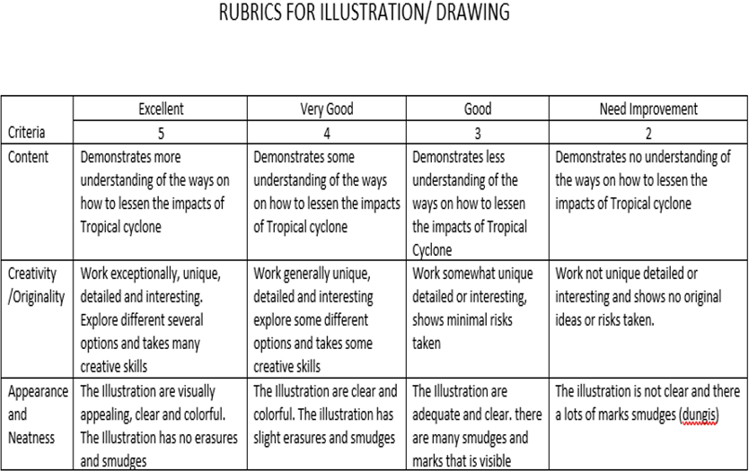
Rubrics for Illustration/Drawing

Illustrate or draw ways on how to lessen the impacts or effects of tropical cyclones. Submit your output at my deped gmail account. On or before Feb.26, 2021


Slide image

Tracking of Tropical Cyclone

Slide image

Show answer

Auto Play

Slide 1 / 52

SLIDE