
Latitude and Longitude
Presentation
•
Geography
•
6th - 8th Grade
•
Practice Problem
•
Medium

Jessica Kweitel
Used 55+ times
FREE Resource
11 Slides • 4 Questions
1
Understanding Location

2
3
4
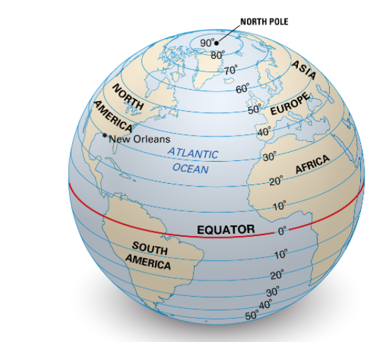
Latitude
Lat is Flat
Lines of latitude are imaginary lines that run around the earth’s circumference.
They run parallel to each other so they are known as the parallels of latitude.
The most important line of latitude is the equator and divides the world into North and South.

5
Multiple Choice

Which streets are parallel on the following map of the CBD
6
Important
Latitude is measured in degrees North and degrees South.
North Pole is 90° N
7
Multiple Choice

what latitude is the Equator?
8
IMPORTANT NOTES
North Pole – 90° N
Arctic Circle – 66.5° N
Tropic of Cancer – 23.5° N
Equator – 0°
Tropic of Capricorn – 23.5° S
Antarctic Circle – 66.5° S
South Pole – 90° S

9
IMPORTANT NOTES
North Pole – 90° N
Arctic Circle – 66.5° N
Tropic of Cancer – 23.5° N
Equator – 0°
Tropic of Capricorn – 23.5° S
Antarctic Circle – 66.5° S
South Pole – 90° S
10
What does changing your latitude change?
Latitude influences CLIMATE
Solar radiation is stronger and more direct at the equator. This means that places at the equator are hotter than places near the Poles.

11
CLIMATE - Draw and label into your book or draw the Key
Tropical is Red
Temerate is green
Polar is light blue

12
Multiple Choice

What does this represent
13
Lines of Longitude
Also called meridians
Run North South direction
0 degrees is the Prime Meridian
Prime Meridian runs through Greenwhich England
Furthest apart at equator and meet at the poles...
Therefore...they are NOT parallel.

14
Multiple Choice
15
What do meridian lines of longitude do?
Influence time zone
There are 24 hours in a day and 24 time zones. Each zone is 15° wide.
There are 24 hours in a day and 24 time zones. Each zone is 15° wide.

Understanding Location
Show answer
Auto Play
Slide 1 / 15
SLIDE
