Search Header Logo
Contour lines

Contour lines

Assessment

Presentation

Geography

5th - 10th Grade

Medium

Created by

#Serbianspirit #Serbianspirit

Used 254+ times

FREE Resource

7 Slides • 11 Questions

1

Contour lines

​Done by:

​Mr. Milos Vidosavljevic

​Geography Teacher

​SAIS - UAQ - UAE

​September 2021

media
media

2

Lesson objectives:

​,, I can''

​- Define a contour line on a Topographic map

​- Identify different types of contour line

​- Identify the importance of Contour lines

3

Open Ended

What do you know about contour lines? 

4

​Contour lines are the most common method of showing relief and elevation on a standard Topographic map. It is drawn to show places of equal heights. Contour lines we can find only on a Topographic map where they can give us information about elevation, shape and a slope of an area.

Contour lines are imaginary lines joining places of equal elevation above mean sea level.

media

5

​There are 3 different types of contour lines:

1. Index

​2. Intermediate

​3. Supplementary

media

6

1. Index contour lines

​These lines are ticker than other contour lines and they are labeled with the number of elevation. Index contours occur every fifth contour line.

media

7

2. Intermediate contour line

​These contour lines are falling between index contour lines, they are finer, tiner than index lines and they don't have their elevations given. There are normally 4 Intermediate lines between two index contour lines.

media

8

​3. Supplementary contour line

​These lines resemble dashes. They show changes in elevation of at least one half the contour interval.

media

9

Open Ended

Question image

Label Index and Intermediate contour line.

10

Multiple Choice

The distance between contour lines is known as

1

Lines

2

Interval

3

Interval lines

4

Contours intervals

11

Multiple Choice

Question image

Every fifth contour line, usually darker is referred to as

1

Contour

2

Index contour lines

3

Intermediate contour line

12

Multiple Choice

Question image

The contour interval

1

20m

2

60m

3

10m

4

5m

13

Multiple Choice

Question image

What are these maps called?

1

Line Maps

2

Topographic Maps

3

Circle Maps

4

Mountain Maps

14

Multiple Choice

Question image

How many peaks are on the map? (hill tops)

1

4

2

3

3

2

4

1

15

Multiple Choice

_____________ is the height above sea level.

1

elevation

2

relief

3

contour

4

topography

16

Multiple Choice

Question image

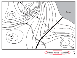
What is the elevation at Position A?

1

1600

2

1500

3

20

4

240

17

Multiple Choice

Question image

What is the elevation at position B?

1

1500

2

1600

3

20

4

240

18

Open Ended

Question image

EXIT TICKET: 

1. Identify 3 types of Contour lines

2. Explain one of the contour line types.

3. What contour lines are showing to us?

Contour lines

​Done by:

​Mr. Milos Vidosavljevic

​Geography Teacher

​SAIS - UAQ - UAE

​September 2021

media
media

Show answer

Auto Play

Slide 1 / 18

SLIDE