
G9 - Topographic maps - Elevation and Slope
Presentation
•
Geography
•
5th - 10th Grade
•
Easy
#Serbianspirit #Serbianspirit
Used 105+ times
FREE Resource
5 Slides • 11 Questions
1
Topographic maps - Elevation and Slope
Done by:
Mr. Milos Vidosavljevic
Geography Teacher
SAIS - UAQ - UAE
September 2021
2
Lesson objectives:
,, I can''
- Define elevation and slope
- Identify the importance of contour lines in showing elevation and slope on a Topographic map
3
Open Ended
What do you know about the elevation and the slope?
4
Many maps are showing elevation but only Topographic maps are showing elevation in details for the whole area presented on the map.
Elevation is the height of an object above the sea level. The elevation at the sea level is zero (0). Elevation is generally reported in meters or feet. Usually, elevation is shown by contour lines.
5
Multiple Choice
The height above sea level is called
topographic
contour
elevation
depth
6
Multiple Choice
What is the elevation of point B?
800 ft
850 ft
900 ft
1000 ft
7
Multiple Choice
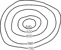
Determine the contour interval:
5 m
10 m
15 m
20 m
8
Draw
Draw your understanding of the Elevation?
9
Slope
The rate of rise or fall of a terrain feature is known as its slope. The speed at which things or people can move is affected by the slope of the ground or an area feature. This slope can be determined from the map by studying the contour lines.
The closer the contour lines are the steeper the slope is. The farther apart the contour lines are the gentler the slope is.
10
Open Ended
Critical thinking: How the slope can affect hikers?
11
12
Multiple Choice
If contour lines are close together, then the slope is
gentle
steep
flat
going up and down
13
Multiple Choice
Which one is the steepest?
2
1
4
14
Multiple Choice
What do contour lines that are farther apart represent?
waterfall
steep area
gentle slope
river
15
Match
Contour lines close together
Contour lines far apart
Fall or a rise of a terrain
The difference between the lowest and the highest point
Zero meters
Steep slope
Gentle slope
Slope
Elevation
Sea level
Steep slope
Gentle slope
Slope
Elevation
Sea level
16
Open Ended
EXIT TICKET:
1. Explain elevation?
2. Explain slope?
Topographic maps - Elevation and Slope
Done by:
Mr. Milos Vidosavljevic
Geography Teacher
SAIS - UAQ - UAE
September 2021
Show answer
Auto Play
Slide 1 / 16
SLIDE
Similar Resources on Wayground
11 questions
IPDI 1 (Clash of Civilization)
Presentation
•
KG
8 questions
Health
Presentation
•
6th - 10th Grade
11 questions
KETAHANAN PANGAN
Presentation
•
KG
15 questions
Grade 9 - Geography - Map symbols
Presentation
•
5th - 10th Grade
9 questions
Reading Strategies
Presentation
•
6th - 8th Grade
12 questions
Irony
Presentation
•
6th - 9th Grade
10 questions
light
Presentation
•
6th - 10th Grade
13 questions
Flag Football
Presentation
•
6th - 9th Grade
Popular Resources on Wayground
20 questions
Math Review
Quiz
•
3rd Grade
15 questions
Fast food
Quiz
•
7th Grade
20 questions
Context Clues
Quiz
•
6th Grade
20 questions
Inferences
Quiz
•
4th Grade
19 questions
Classifying Quadrilaterals
Quiz
•
3rd Grade
20 questions
Figurative Language Review
Quiz
•
6th Grade
20 questions
Equivalent Fractions
Quiz
•
3rd Grade
10 questions
Identify Fractions, Mixed Numbers & Improper Fractions
Quiz
•
3rd - 4th Grade
Discover more resources for Geography
20 questions
State and Capital (States 1-20)
Quiz
•
5th Grade
50 questions
US States & Capitals
Quiz
•
7th Grade
40 questions
Flags of the World
Quiz
•
KG - Professional Dev...
71 questions
Final Review 2026
Quiz
•
9th Grade
28 questions
Tri 3 Final- Asia
Quiz
•
8th Grade
41 questions
Tri 3 Mapping
Quiz
•
8th Grade
16 questions
Tri 3 Final- Misc
Quiz
•
8th Grade
15 questions
Tri 3 Review- Middle East
Quiz
•
8th Grade