Search Header Logo
G9 - Contour lines - types of landforms

G9 - Contour lines - types of landforms

Assessment

Presentation

Geography

5th - 10th Grade

Medium

Created by

#Serbianspirit #Serbianspirit

Used 91+ times

FREE Resource

7 Slides • 10 Questions

1

Contour lines - types of landforms

Done by:

​Mr. Milos Vidosavljevic

​Geography Teacher

​SAIS - UAQ - UAE

​September 2021

media

2

​Lesson objectives:

​- Define new vocabulary terms related to the lesson

​- Explain how contours represent different types of landforms.

3

Open Ended

What is the importance of Contour lines on a Topographic map?

4

Hill - a hill is an area that rises almost uniformly from the surrounding land. From a hilltop, the ground slopes down in all directions. A topographic map shows a hill by contour lines forming concentric circles. The inside of the most minor closed loop is the hilltop.

media

5

Plateau - is ​a widely stretched flat topped highland, with relatively steeper slopes. The middle part of contour lines presenting a plateau is widely stretched.

media

6

​HILL - PLATEAU COMPARSION

media

7

A ​Valley - is stretched out groove in the land, usually formed by streams and rivers. A valley begins with high ground, on three sides and usually has a course of running water through it.

​Contour lines forming a valley are either U-shaped or V-shaped. To determine the direction water is flowing we have to look at the contour lines. The closed and of the contour line (U OR V SHAPE) always points upstream or toward high ground.

8

media

River valley presented with contour lines

9

Draw

Draw an example of a Hill, Plateau, and valley by using the contour lines. Name them below.

10

Multiple Choice

Question image

Is point A at the bottom or the top of the hill?

1

Bottom

2

Top

11

Multiple Choice

Question image

Match the topographic map to its profile picture.

1
2
3
4

12

Multiple Choice

Question image

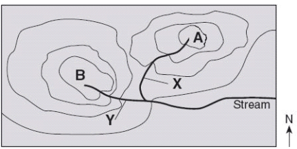
Which direction is the stream flowing?

1

northward

2

southward

3

westward

4

eastward

13

Multiple Choice

Question image

Match 4

1

C

2

D

3

E

4

F

14

Multiple Choice

Question image

Match 2

1

B

2

C

3

D

4

E

15

Multiple Choice

Question image

Match 1 

1

A

2

B

3

C

4

D

16

Multiple Choice

Question image

The image shows a topographic map.

Which statement best describes the location marked by the X?

1

It is at the bottom of a large pit.

2

It is at the top of a hill.

3

It is on the side of a mountain.

4

It is in a deep cave.

17

Open Ended

Question image

EXIT TICKET: 

1. What are 2 things you learned today?

2. Explain the meaning of plateau.   

Contour lines - types of landforms

Done by:

​Mr. Milos Vidosavljevic

​Geography Teacher

​SAIS - UAQ - UAE

​September 2021

media

Show answer

Auto Play

Slide 1 / 17

SLIDE