Search Header Logo
Gr 9 Review  - Map Reading and Skills

Gr 9 Review - Map Reading and Skills

Assessment

Presentation

Geography, Social Studies

9th - 12th Grade

Easy

Created by

Brian Daley

Used 3+ times

FREE Resource

7 Slides • 31 Questions

1

Gr 9 Geo in Review

media

This is a review on Map reading Skills and content that was to be covered specifically in Gr 7

2

Types of Maps

Latitude vs Longitude

Landforms​

What is a Map?

Map vs Globe

Features of a Map

Distance

Direction​

​Mapping and Map Reading Skills

Some text here about the topic of discussion

3

media

4

​MAP VS GLOBE

Some text here about the topic of discussion

5

Multiple Choice

Question image

A 3D sphere that shows a map of the earth is called a...

1

globe

2

continent

3

country

4

ball

6

Multiple Choice

A map has ___________that stand for objects.

1

compass roses

2

directions

3

map keys

4

symbols

7

Multiple Choice

What part of a map shows what the symbols mean?

1

map key

2

political map

3

physical map

4

compass rose

8

Multiple Choice

Question image

What is this map element called?

1

Legend

2

Star Guide

3

Cardinal Diamond

4

Compass Rose

9

Multiple Choice

Question image

What direction is missing?

1

north

2

south

3

east

4

west

10

​COMPASS DIRECTION

Some text here about the topic of discussion

11

Multiple Choice

Which of the following is NOT a cardinal direction?

1

north

2

south

3

southeast

4

west

12

Multiple Choice

Question image
In which direction would you have to travel to go from the bank to the hospital?
1
North
2
South
3
East
4
West

13

Multiple Choice

Question image

What cardinal direction goes in the yellow box?

1

east

2

west

3

south

4

north

14

Multiple Choice

Question image

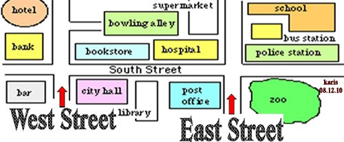
In which direction would you have to travel to go from city hall to the bowling alley?

1
North
2
South
3
East
4
West

15

Multiple Choice

What does the four main points on the compass is called?

1

Direction points

2

cardinal points

3

regional points

16

Multiple Choice

Question image

Which letter represents south west?

1

A

2

H

3

F

4

D

17

Multiple Choice

Question image

What CONTINENT is north of Africa?

1

Antarctica

2

South America

3

Europe

4

Australia

18

Multiple Choice

Question image

What CONTINENT is southeast of Asia?

1

Africa

2

Europe

3

Australia

4

Antarctica

19

Multiple Choice

What are the 4 intermediate directions?

1

North, East, West, South

2

West, Southwest, North, Northwest

3

Southeast, Southwest, Northeast, Northwest

20

Multiple Choice

What are the 4 cardinal directions?

1

Northeast, Northwest, Southeast, Southwest

2

North, East, South, West

3

Westeast, Northsouth, Southnorth, Northeast

21

​TYPES OF MAPS

Some text here about the topic of discussion

22

Multiple Choice

Question image

Major cities and capital cities noted on map is called a....

1

Physical Map

2

Political Map

23

Multiple Choice

Question image

A map that shows physical features of the land is called a...

1

Physical Map

2

Political Map

24

Multiple Choice

Something you would find on a physical map is...

1

a highway

2

a lake

3

a different subject

4

a border between states or countries

25

Multiple Choice

What type of map would you use if you wanted to find the countries bordering France?

1
Political
2
Physical
3

Road

4

Population

26

Multiple Choice

Shows what the temperatures and rainfall or snow is like in an area.

1

Physical Map

2

Political Map

3

Climate Map

4

Road Map

27

Multiple Choice

This type of map shows where gold and silver is located

1

Political Map

2

Physical Map

3

Natural Resource Map

4

Climate Map

28

Some text here about the topic of discussion

LONGITUDE AND LATITUDE

29

Multiple Choice

What shape is the planet Earth?
1
Circle
2
hemisphere
3
sphere
4
cone

30

Multiple Select

Latitude lines on a globe are labeled-
1

south to north

2

east to west

3

north to south

4

west to east

31

Multiple Choice

Question image
1
The map show the lines of longitude.
2
The map shows the lines of latitude.

32

Multiple Choice

Question image
Latitude and longitude are measured in ________.
1

cups

2

gallons

3

degrees

4

Fahrenheit

33

Multiple Choice

Question image
What is the name of the line at zero degrees longitude?
1

Equator

2

Prime Meridian

3

International Date Line

4

North Pole

34

Multiple Choice

A _______________ is exactly half of the earth.
1
Equator
2
Hemisphere
3
Tropic of Cancer
4
Arctic Circle

35

Multiple Choice

Lines of longitude are also called  ____________.
1
Hemispheres
2
Meridians
3
parallels
4
International Date Lines

36

Multiple Choice

The equator divides the Earth into what two hemispheres?

1

Eastern and Southern

2

Northern and Southern

3

Western and Eastern

4

Northern and Western

37

Multiple Choice

Question image

A 3D sphere that shows a map of the earth is called a...

1

globe

2

continent

3

country

4

ball

38

Poll

How do you feel about what you know just learnt?

Very Confident

Fairly Confident

Slightly Confident

Not Confident

Gr 9 Geo in Review

media

This is a review on Map reading Skills and content that was to be covered specifically in Gr 7

Show answer

Auto Play

Slide 1 / 38

SLIDE