Science
Presentation
•
•
Practice Problem
•
Hard
Kyle Oakes
FREE Resource
21 Slides • 72 Questions
1
Multiple Select
What two possible techniques could scientists have used to create this map of the ocean ridges?
detecting new landforms
observing from underwater vehicles
monitoring sound waves
comparing mountain ranges
surveying land levels
2
Multiple Choice
Complete the sentence:
Volcanoes can form on _______________________
the ocean floor or land
plate movement
glaciers and icebergs
state boundaries
3
Multiple Choice
A landform is a physical feature on the Ocean’s surface.
True
False
4
Multiple Choice
Plateaus, valleys, canyons, and mountains are all examples of:
Highlands
Mantle areas
Landforms
Hydrosphere
5
Multiple Choice
A landform that rises high above the Earth’s surface:
Hill
Valley
Mountain
Plateau
6
Multiple Choice
A close-up look at Earth shows you many natural features on the surface. These features are called...
highlands
landforms
7
Multiple Choice
A natural elevation of the Earth’s surface, smaller than a mountain...
Hill
Valley
Mountain
Plateau
8
Multiple Choice
Which shows the elevation of an area using contour lines?
Mountains
Faults
Topographical map
Cartographer
9
Multiple Choice
A deep valley with high, steep sides...
Hill
Valley
Mountain
Canyon
10
Multiple Choice
Latitude and longitude are used to:
Find a location of a specific place or landform feature on a map.
Determine the shape of the Earth.
11
Multiple Choice
Where a body of water meets land...
Ocean
Lake
Coast
River
12
Multiple Choice
An area with very little precipitation...
Hill
Desert
Canyon
Plateau
13
Multiple Choice
The flattest part of the ocean floor is called...
abyssal plain
continental shelf
14
Multiple Choice
The abyssal plains cover about ___ percent of the Earth’s surface.
40
50
60
70
15
Multiple Choice
Earth’s outer layer is called...
Crust
Mantle
Outer core
Inner core
16
Multiple Choice
A map that shows the elevation of an area using shades is called:
Topographical map.
Relief map
Physical map
17
Multiple Choice
The place where two plates meet is called...
Plate boundary
Volcanic plates
18
Multiple Choice
Is used to describe how far north or south a place is from the equator:
Latitude
Longitude
Prime Meridian
19
Multiple Choice
The deepest part of the Ocean floor is called:
Seamount
Trench
20
Multiple Choice
An opening on Earth’s surface where melted rock or gases are forced out is called:
Earthquake
Volcano
21
Multiple Choice
What is a topographic map?
shows elevation of an are using lines
an opening in the earth's surface where gas and rock are forced out
a sudden movement of the earth's crust
a large landmass
22
Multiple Choice
What is an earthquake?
a sudden movement of the earth's crust
a very large piece of the earth's crust
used to describe how far north or south a place is from the equator
a large landmass
23
Multiple Choice
What is latitude?
used to describe how far east or west a place is from the Prime Meridian
shows elevation of an area using lines
used to describe how far north or south a place is from the equator
a sudden movement of the earth's crust
24
Multiple Choice
What is longitude?
a large landmass
used to describe how far east or west a place is from the prime meridian
a physical feature of the earth's surface
used to describe how far north or south a place is from the equator
25
Multiple Choice
What is a volcano?
a very large piece of the earth's crust
a sudden movement of the earth's surface
a large landmass
an opening in the earth's surface where melted rock or gases are forced out
26
Fill in the Blanks
Type answer...
27
Multiple Choice
a process in which a force acts on a rock and breaks it into smaller pieces
erosion
sediment
rate of erosion
weathering
28
Multiple Choice
If you see contour lines on a map that are very close together, which of the following landforms is most likely in that location on the map?
a flat, sandy beach
a mountain
the plains
29
Multiple Choice
How do contour lines on a map show a flat plain on a map?
The contour lines are far apart for a plain.
The contour lines are very close together to show a flat plain.
The contour lines are wide and short to show a flat plain.
The contour lines are long and narrow to show a flat plain.
30
Multiple Choice
A volcano is most likely to occur __________.
in a valley
on land
near the boundaries of tectonic plates
underwater
31
Multiple Choice
How do scientists create a map of the ocean floor?
Scientists compare mountain ranges.
Scientists use sonar or sound waves to map the ocean floor's features.
Scientists measure land levels.
Scientists look for new landforms.
32
Multiple Choice
How would a map of the land and the ocean be similar?
Both maps show plant life.
Both maps show earthquakes.
Both maps show valleys and mountains.
33
Multiple Choice
A river, delta, mountain, valley, plains, and plateau are all examples of ________________.
the Earth's mantle.
landforms.
the hydrosphere.
34
Multiple Choice
A landform is __________________.
part of the hydrosphere.
the core of the Earth.
molten rocker beneath the Earth's surface.
a feature of the Earth's surface.
35
Multiple Choice
Sediments are tiny bits of soil or rock that have been broken down and deposited.
True
False
36
Multiple Select
Which are deposit most of the sediments?
Water
Wind
37
Multiple Choice
Sedimentary rock forms from sediments that are not pressed together in layers.
True
False
38
Multiple Choice
Fossils, remains or imprints of living things from the
Past
Present
39
Multiple Choice
A type of rock made from molten lava
igneous rock
sedimentary rock
metamorphic rock
fossil
40
Multiple Choice
Rock formed from particles in the environment that settle to form layers
igneous rock
sedimentary rock
metamorphic rock
fossil
41
Multiple Choice
A type of rock formed by great pressure and very high temperatures
igneous rock
sedimentary rock
metamorphic rock
fossil
42
Multiple Choice
Mineralized remains or evidence of plants and animals that lived long ago
igneous rock
sedimentary rock
metamorphic rock
fossil
43
Multiple Choice
This organism is dissolved in the Earth and leaves a 3D indentation
trace fossil
mold fossil
true form fossil
cast fossil
44
Multiple Choice
Impressions such as footprints, burrows, or nests once made by living organisms
trace fossil
mold fossil
true form fossil
cast fossil
45
Multiple Choice
Mineralized sediment fills a cavity and recreates the shape of the remains.
trace fossil
mold fossil
true form fossil
cast fossil
46
Multiple Choice
This fossil is formed when the dead plant or animal IS the fossil.
trace fossil
mold fossil
true form fossil
cast fossil
47
Multiple Choice
Which layer contains fossils of the oldest organisms? Explain your answer.
Layer A because it has the weirdest creature
Layer D because it's on the top
Layer A because it's on the bottom
Layer D because dinosaurs are old
48
49
50
Multiple Choice
Tiny bits of soil or rock that have been broken down and deposited are called ________?
deposits
sediments
layers
rocks
51
52
53
Multiple Choice
Where are fossils preserved in?
metamorphic rocks
The Rock
sedimentary rocks
igneous rocks
54
55
56
Multiple Choice
Fossils found closer to the surface are usually ____________ than the other fossils deeper below.
older
brighter
newer
darker
57
58
59
Multiple Choice
What can affect the formation and patterns found in rock layers?
earth forces
dark forces
energy
sedimentary rocks
60
61
62
Multiple Choice
How are canyons formed?**
water slowly removes rock particles
cliffs decide to break off
volcanoes melt the rocks
63
Multiple Choice
The oldest layer of rock is layer _________________, and the youngest layer of rock is layer ____________________.
1; 5
2;4
3;2
4;3
64
65
Multiple Choice
Weathering is the ________ process that breaks down materials into smaller pieces.
fast
slow
neutral
speedy
66
67
68
Multiple Choice
The action of rocks and sediments grinding and wearing away surfaces is called _________.
weathering
cracks
abrasion
polishing
69
70
Multiple Select
What three things can cause chemical weathering?
water
ash
oxygen
abrasion
living things
71
72
Multiple Choice
The movement of weathered materials from one place to another is called ________?
erosion
weathering
deposition
73
74
Multiple Choice
What causes material to move?
mud
gravity
land
rock
75
76
Multiple Choice
Sediments that build up turns into a landform called _______?
island
peninsula
delta
beach
77
78
Multiple Choice
What do you call deposits of wind-blown sand?
sand dune
beach
mountain
sand castle
79
80
Multiple Choice
An area of shoreline made of material deposited by waves is called a _______.
beach
sand dune
ocean
cliff
81
82
Multiple Choice
What forms where snow collects quickly and melts slowly?
avalanche
hill
glaciers
83
84
Multiple Choice
Too much rain can have negative effects on some wildlife.
true
false
85
Multiple Choice
______________________ is the study of Earth's shapes and features.
interval
topography
elevation
contour
86
Multiple Choice
______________________ are lines that connect areas of the same elevation and eventually form a closed loop.
contour lines
parallel lines
intersecting lines
relief lines
87
Multiple Choice
_______________ is the distance between contour lines that represent the difference in elevation points.
topography
topographic map
contour lines
contour intervals
88
Multiple Choice
_____________ is the height above sea level.
elevation
relief
contour
topography
89
Multiple Choice
The closer the contour lines are together, the ______________ the slope.
thinner
wider
flatter
steeper
90
Multiple Choice
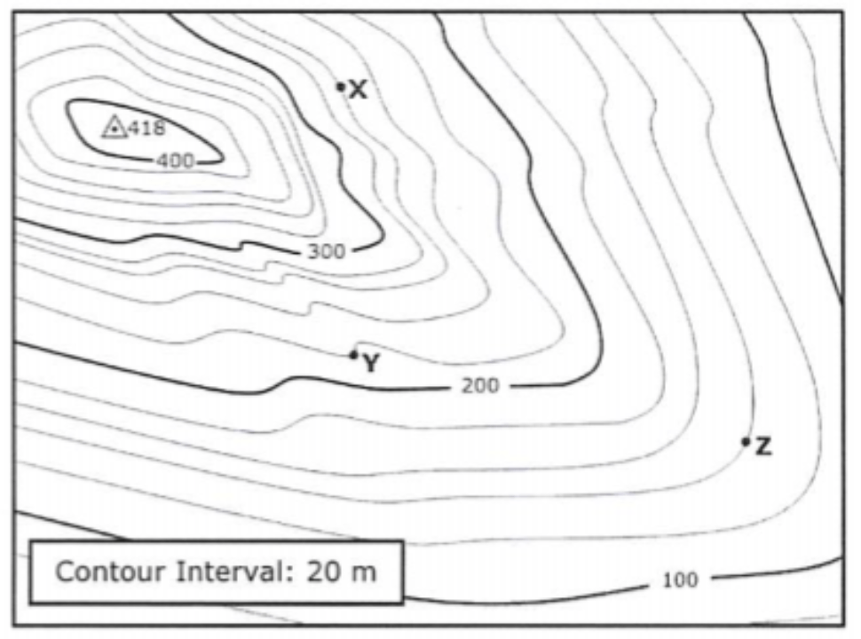
What is the elevation of point X?
240 meters
250 meters
260 meters
270 meters
91
Multiple Choice
What is the elevation of point Y?
220 meters
210 meters
200 meters
215 meters
92
Multiple Choice
What is the elevation of point Z?
130 meters
135 meters
140 meters
150 meters
93
Multiple Choice
What is the difference in elevation between points X and Y?
30 meters
20 meters
40 meters
10 meters
What two possible techniques could scientists have used to create this map of the ocean ridges?
detecting new landforms
observing from underwater vehicles
monitoring sound waves
comparing mountain ranges
surveying land levels
Show answer
Auto Play
Slide 1 / 93
MULTIPLE SELECT

Similar Resources on Wayground
85 questions
World Geography review
Presentation
•
7th - 8th Grade
85 questions
BAB 11-KITAR SEMULA
Presentation
•
8th Grade
87 questions
Hydraulic brakes ppt
Presentation
•
9th - 12th Grade
87 questions
Chapter 7 - System Life Cycle
Presentation
•
8th - 9th Grade
85 questions
B1 Tema 3. Producción y costes
Presentation
•
11th Grade
87 questions
Practice FSA 5th grade Reading
Presentation
•
5th Grade
87 questions
WWI DC
Presentation
•
University
87 questions
Communism in China
Presentation
•
7th Grade - University
Popular Resources on Wayground
10 questions
Safety Day 2026 – Student Review
Quiz
•
9th Grade
21 questions
Continents and Oceans
Quiz
•
6th Grade
20 questions
Parts of Speech
Quiz
•
5th Grade
16 questions
Subject & Predicate
Quiz
•
5th Grade
25 questions
Multiplication Facts
Quiz
•
5th Grade
12 questions
Map Skills
Quiz
•
3rd Grade
22 questions
Continents and Oceans
Quiz
•
5th Grade
15 questions
Rounding Decimals
Quiz
•
5th Grade
Discover more resources for
26 questions
SLIME!!!!!
Quiz
•
KG - 12th Grade
20 questions
Place Value
Quiz
•
KG - 3rd Grade
4 questions
K-2 Force and Motion Lesson
Presentation
•
KG - 2nd Grade
12 questions
Tone and Mood
Presentation
•
KG
10 questions
Day and Night Patterns
Quiz
•
KG
20 questions
Disney Characters
Quiz
•
KG
12 questions
Nouns and Verbs
Quiz
•
KG - 2nd Grade
15 questions
Short Vowels
Quiz
•
KG - 2nd Grade