
Search Header Logo
  1. Resource Library
  2. Social Studies
  3. Geography
  4. Geography Review
Geography Review

Geography Review

Assessment

Presentation

•

Social Studies

•

5th Grade

•

Practice Problem

•

Medium

Created by

Madalena Piccininni

Used 10+ times

FREE Resource

0 Slides • 12 Questions

1

Multiple Select

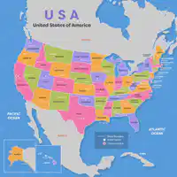
What are the names of the 5 U.S. Regions?

1

West

2

Southwest

3

Northeast

4

Southeast

5

Middle West

2

Multiple Choice

What is a road map?

1

shows something found in nature that is useful for people in the area

2

shows cities, streets, highways, and points of interest

3

a map that shows how many people live in the area

4

a map that shows how high or low land is by using colors

3

Multiple Choice

What is Georgraphy?

1

the scientific study of material remains (such as tools, pottery, jewelry, stone walls, and monuments) of past human life and activities

2

a science dealing with the life of past geologic periods as known from fossil remains

3

the branch that deals with living organisms

4

the study of earth

4

Multiple Choice

What are the 4 cardinal directions?

1

North, South, East,West, Northeast, Southeast

2

North, South, East,West

3

Northeast, Southeast

4

North, South

5

Multiple Choice

What are the INTERMEDIATE directions?

1

North, South

2

North, South, West, East

3

Northeast, Northwest, Southeast, Southwest

4

Northeast, Southeast

6

Multiple Select

Question image

Which materials are natural resources from this map?

1

coal

2

straws

3

trees/forest

4

gold

7

Multiple Choice

  1. Which one of these are examples of precipitation?

1

snow

2

rain

3

sleet

4

all of the above

8

Multiple Choice

Latitude and Longitude lines cross to form a _______________.

1

rectangles

2

grid

3

triangle

4

trapezoid

9

Multiple Choice

What U.S. Region is New York located in?

1

Southeast

2

Middle West

3

West

4

Northeast

10

Multiple Choice

What is a climate map?

1

shows the weather patterns of a particular area over time

2

shows countries, capitals, and boundaries

3

shows landforms and bodies of water, such as mountains, deserts, plains, rivers, and oceans

4

shows how high or low land is by using colors

11

Multiple Choice

Latitude lines run ________ and __________

1

North and South

2

East and West

3

diagonal

4

criss-cross

12

Multiple Choice

Longitude lines run ________ and ________.

1

East and West

2

diagonal

3

North and South

4

criss-cross

pattern-tertiary

What are the names of the 5 U.S. Regions?

1

West

2

Southwest

3

Northeast

4

Southeast

5

Middle West

Show answer

Auto Play

Slide 1 / 12

MULTIPLE SELECT
