
Geography of Sea Asia
Presentation
•
Geography
•
7th Grade
•
Hard

Joseph Anderson
FREE Resource
11 Slides • 24 Questions
1
Physical Geography of Southeast Asia
*and a little bit about East Asia too
7.2.1 PR Places and Regions in Asia
7.2.2 ER Environment and Resources in Asia

2
Southeast Asia is located...
south of China and east of India
between the Indian Ocean and the Pacific Ocean
mostly in the tropical zone (between the Tropic of Cancer and the Tropic of Capricorn)

3
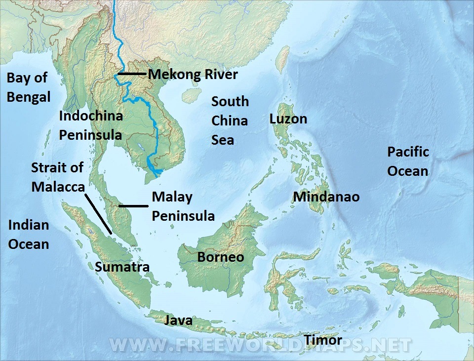
Physical Features of Southeast Asia
The mainland countries of SE Asia are on the Indochina Peninsula.
An archipelago is an island chain. Indonesia and the Philippines are archipelagos in Southeast Asia.
Major islands in the archipelagos include Borneo, Sumatra, Java and Timor in Indonesia, and Luzon and Mindanao in the Philippines.
4
Major Bodies of Water in SE Asia
The Mekong is a major river.
The Bay of Bengal and Indian Ocean lie to the west of SE Asia.
The South China Sea lies between Indochina and the Philippines.
The Pacific Ocean lies to the east.
The Strait of Malacca is the main shipping channel between the Indian and Pacific oceans.
5
Multiple Select
6
Multiple Select
7
Multiple Choice
8
Multiple Choice

This is a map of Southeast Asia. What is the name of the peninsula located at number 3?
9
Multiple Choice
This is a map of Southeast Asia. Which number correctly identifies the island of Borneo?
10
Multiple Choice
This is a map of Southeast Asia. Which number correctly identifies the Strait of Malacca?
11
Multiple Choice
This is a map of Southeast Asia. Which number correctly identifies the Mekong River?
12
SE Asian nations on Indochina peninsula:
Myanmar
Thailand
Laos
Cambodia
Vietnam
*Malaysia (on the peninsula)

13
SE Asian nations on island archipelagos:
*Malaysia (on island of Borneo)
Singapore
Brunei
Indonesia
East Timor
Philippines
14
Major cities in SE Asia
A megacity is a city with a population of over 10 million. There are three in Southeast Asia.
Jakarta, Indonesia (34 million)
Manila, Philippines (23 million)
Bangkok,Thailand (14 million)
Singapore (not a megacity - independent city-state)

15
Multiple Choice

Which number correctly identifies the location of the country of Myanmar or Burma?
16
Multiple Choice
Which number correctly identifies the location of the country of Laos?
17
Multiple Choice
Which number correctly identifies the location of the country of Vietnam?
18
Multiple Choice
Which number correctly identifies the location of the country of Thailand?
19
Multiple Choice
Which number correctly identifies the location of the country of Cambodia?
20
Multiple Choice
Which number correctly identifies the location of city-state of Singapore?
21
Multiple Choice
Which number correctly identifies the location of country of Brunei?
22
Multiple Choice
Which number correctly identifies the location of country of Malaysia?
23
Multiple Choice
Which number correctly identifies the location of country of Indonesia?
24
Multiple Choice
Which number correctly identifies the location of country of the Philippines?
25
Biomes of SE Asia (Climate/Vegetation)
Because most of SE Asia is located in the tropics, it is mostly tropical rainforest that is hot and humid or wet most of the year.
Most rainfall comes from the monsoon season in the summer months from April to September.
The monsoons allow rice and tea to be grown in this region.

26
Biomes of East Asia (Climate/Vegetation)
East Asia is located north of the Tropic of Cancer in the northern temperate zone. This means the temperatures are fairly mild, with warm summers and cool winters, except in highlands and deserts.
The western part of China is mountains and deserts. The eastern part, plus Korea and Japan are temperate forests.

27
Multiple Choice

Which answer best explains why the climate of Southeast Asia is more hot and humid than the climate of East Asia?
28
Multiple Choice
How does monsoon season impact Southeast Asia?
29
Agriculture in East and Southeast Asia
Rice farming began in China in ancient times and spread to Korea, Japan and Southeast Asia. Tea is also a major crop.
In flat lands, rice is grown in flooded fields called paddies.
In hilly areas, like much of SE Asia, terraces, like steps, are cut into the hillside to grow rice.

30
Natural Resources of East and SE Asia
Japan is poor in natural resources and exports technology to get the resources it needs (oil, etc.)
China is very rich in natural resources, including many minerals such as coal.
SE Asia is rich in rubber and minerals like tin, lead, etc.
The Strait of Malacca is a very important shipping channel.

31
Multiple Select
32
Multiple Choice

What form of agriculture practiced in parts of Southeast Asia is being shown in this picture?
33
Multiple Choice
34
Multiple Choice
35
Multiple Choice

Why does Singapore's location give it an advantage in world trade?
Physical Geography of Southeast Asia
*and a little bit about East Asia too
7.2.1 PR Places and Regions in Asia
7.2.2 ER Environment and Resources in Asia
Show answer
Auto Play
Slide 1 / 35
SLIDE
