

IGCSE Hazards-Revision

Presentation
•
Geography
•
KG - Professional Development
•
Easy

Aimee Cooper
Used 1+ times
FREE Resource
34 Slides • 22 Questions
1

2
Types of hazards
We can group natural hazards into different categories depending on what causes them.
Geophysical hazards are caused by movements of the Earth.
Hydrological hazards are linked to water.
Climatological hazards happen because of long-term weather patterns.
Meteorological hazards are linked to short-term weather events.
Finally, biological hazards are caused by living things. Sorting hazards into these categories helps us understand their causes and how we can respond to them.

3
Categorize
Earthquakes
Tsunamis
Volcanoes
Landslides
Floods
Avalanches
Drought
Wildfires
Extreme Temperatures
Storms
Disease epidemics
Insect plagues
What type of hazard are these?
4
Open Ended

What factors effect the severity of a hazard?
5

6
Open Ended

What trends does it show?
How reliable is the data?
What other factors could explain the trend shown?
7
Open Ended
Explain why lower income countries (LICs) have a higher death rate than higher income countries (HICs) during natural hazards
(4)
8
LICs often have a higher death rate during natural hazards because they have lower levels of development and wealth. This means they can’t respond as quickly or effectively as HICs. Education levels may also be lower, so people might not know what to do in an emergency. Population density is often high, so more people are affected in a small area. In addition, weaker buildings and poor healthcare services make it harder for people to survive after the event.
Example Answer

9
Draw
Draw your own diagram of the structure of the earth. Label all the main layers.
10

Earth has 4 main layers:
Crust – thin, rocky, solid (5–70 km)
Mantle – thick, semi-solid, moves slowly (2,900 km)
Outer Core – liquid iron & nickel, very hot (2,200 km)
Inner Core – solid metal ball, hottest (1,200 km)

11
Draw
Task: Draw and label a simple convection current diagram.
Arrows to show rising and sinking mantle
Direction of plate movement
Crust and mantle labels
12

Why Do Plates Move? – Convection Currents
The movement of tectonic plates is driven by convection currents in the mantle.
This works like this:
Heat from the Earth's core causes hot mantle rock to rise.
As it reaches the surface, it cools and spreads out, dragging plates with it.
Cooler material sinks back down, creating a continuous cycle.
These currents cause plates to move in different directions and interact at their boundaries.

13
Categorize
Oceanic crust sinks beneath continental crust
Creates explosive volcanoes and strong earthquakes
The Andes Mountains are found here
Crust is destroyed at this boundary
The Himalayas were formed here
Two continental plates crash into each other
Fold mountains are created
No volcanoes, only powerful earthquakes
The San Andreas Fault is located here
Plates slide past each other
Plates move away from each other
Magma rises to form new crust
New land forms at a mid-ocean ridge
The Mid-Atlantic Ridge is found here
Creates shield volcanoes and gentle eruptions
No crust is created or destroyed
Magma rises due to subduction
The Pacific Plate and North American Plate meet here
Crust is pushed upwards to form mountains
Iceland formed at this boundary

Match each statement to the correct plate boundary type.
14
Destructive (Convergent) Plate Boundaries
At destructive boundaries, two plates move towards each other. An oceanic plate (which is denser) sinks beneath a continental plate. This is called subduction.
As the oceanic plate melts, magma rises and causes explosive volcanoes. The movement also causes strong earthquakes.
Example: Nazca Plate and South American Plate (Andes Mountains)

15
Constructive (Divergent) Plate Boundaries
At constructive boundaries, plates move away from each other. As they separate, magma rises from the mantle and cools, creating new crust.
This can form shield volcanoes, often under oceans. The eruptions are usually gentle.
Example: North American and Eurasian Plates (Mid-Atlantic Ridge / Iceland)

16
Collision Plate Boundaries
At collision boundaries, two continental plates move towards each other. Neither plate can sink, so the land is pushed upwards to form fold mountains.
There is no subduction, so no volcanoes, but there are often powerful earthquakes.
Example: Indo-Australian and Eurasian Plates (Himalayas)

17

At conservative boundaries, plates slide past each other in opposite or similar directions. They can get stuck and build up pressure.
When the pressure is released, it causes sudden, violent earthquakes. There are no volcanoes because there’s no magma involved.
Example: North American and Pacific Plates (San Andreas Fault)
Conservative (Transform) Plate Boundaries

18
Hotspots
Hotspots are areas where magma from deep within the mantle rises through a thin part of the crust.
Unlike plate boundaries, hotspots are located in the middle of tectonic plates.
Example: The Hawaiian Islands were formed by volcanic eruptions from a hotspot in the middle of the Pacific Plate.

19
20
Open Ended

Describe the distribution of tectonic hazards
21
Reorder
Explain how an earthquake happens.
Two plates are moving past eachther
They get stuck and start building up pressure as strain energy
suddenly, the pressure gets too much and the rocks slip
the stored energy is released in seismic waves
seismic waves travel through the earth shaking everything. This is an earthquake
22


OH-SO GEOGRAPHY
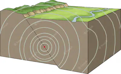
What is an earthquake?
Two huge rock masses push into each other. The rock stores up this energy as strain power.
But suddenly the pressure gets too much. One rock gives way and slips. The stored energy is released in waves.

23


OH-SO GEOGRAPHY
Seismic waves travel through the earth in all directions, shaking everything. This shaking is called an earthquakes.
24


OH-SO GEOGRAPHY
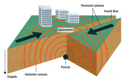
The focus of the earth is the point where the waves start.
The epicenter is the point directly above it on the Earth's surface. This is where the force of the earthquake is strongest.
25
Match
The focus
the epicenter
strain energy
underground where the seismic waves start
above the ground where the damage is strongest
rocks store the build up of pressure.
underground where the seismic waves start
above the ground where the damage is strongest
rocks store the build up of pressure.
26
Open Ended
How are earthquakes measured?
27
Richter Scale
Measures earthquake magnitude
Logarithmic – Each increase of 1 = 10x more powerful
E.g. Mag. 7 is 10x stronger than Mag. 6
The largest earthquake recorded: 1960 Chile, Mag. 9.5

28
Seismograph
This measures the magnitude of a tremor (how powerful it is) using an instrument called a seismograph.
On the Richter Scale, magnitude is expressed in whole numbers and decimal fractions. Although the Richter Scale has no upper limit, the largest earthquake ever recorded was in 1960 in Chile. It measured 9.5 on the Richter Scale.

29
Mercalli Scale
Measures damage felt and observed by people
Subjective – e.g. furniture shaking, buildings falling
Scale of I (not felt) to X(total destruction)

30
Open Ended

What factors determine how destructive an earthquake is?
31
Magnitude
The magnitude of an earthquake is a key factor in how much damage it causes.
🔹 Measured on a logarithmic scale (e.g. Richter or Moment Magnitude).
🔹 Each step up = ~30× more energy released.
🔹 Higher magnitude = more powerful seismic waves = greater destruction.

32
Distance from the Epicentre
The epicentre is the point on the Earth’s surface directly above the focus.
🔹 The closer a location is to the epicentre, the more intense the shaking.
🔹 Damage decreases with distance from the epicentre – seismic waves lose energy.

33
Depth of Focus
The focus is the point underground where the earthquake begins.
🔹 Shallow-focus earthquakes (0–70 km deep) cause the most surface damage.
🔹 Deeper-focus earthquakes lose energy before reaching the surface.

34
Population Density
Areas with more people are at higher risk of casualties and damage.
🔹 Urban areas have more infrastructure to damage – buildings, bridges, roads.
🔹 High population means more people in danger when the ground shakes.

35
Building Design
Buildings can either collapse or protect people.
🔹 Strong building codes (e.g. in Japan) reduce deaths.
🔹 Poorly built homes collapse easily, trapping people.
🔹 Soft ground = worse shaking = more collapse risk.

36
Time of Day
Earthquakes can strike at any time – but timing affects casualties.
🔹 At night: people are inside, sleeping – trapped if buildings collapse.
🔹 In the day: more people are outside – possibly safer (unless in tall buildings or schools).

37
Type of Rocks
Different rock types affect shaking:
🔹 Hard rock transmits seismic waves quickly but causes less shaking.
🔹 Soft sediments (like clay or sand) amplify shaking – “liquefaction” can occur.
🔹 Liquefaction turns ground to mush – buildings sink!

38
Open Ended

Which of these earthquakes would have been more destructive?
39
Categorize
Ground shaking
Surface faulting
Collapsed structures
People dead, trapped or injured
Fires
Aftershocks
Landslides & rockfalls
Electricity, gas, water, sewage and telephone lines cut
Tsunamis
Soil liquefaction
Release of hazardous material
Contaminated water
Spread of diseases
Floods from collapsed dams
People made homeless
Shops and industries have to close down
Rebuilding houses and businesses
Sort the following into the correct categories
40

41
Constructive (Divergent) Plate Boundaries
At constructive boundaries, plates move away from each other. As they separate, magma rises from the mantle and cools, creating new crust.
This can form shield volcanoes, often under oceans. The eruptions are usually gentle.
Example: North American and Eurasian Plates (Mid-Atlantic Ridge / Iceland)
42
Destructive (Convergent) Plate Boundaries
At destructive boundaries, two plates move towards each other. An oceanic plate (which is denser) sinks beneath a continental plate. This is called subduction.
As the oceanic plate melts, magma rises and causes explosive volcanoes. The movement also causes strong earthquakes.
Example: Nazca Plate and South American Plate (Andes Mountains)
43
Fill in the Blanks

44
Open Ended

Explain why volcanoes do not form at collision plate boundaries.
45
Open Ended

Recap: Where do volcanoes occur?
46
Most volcanoes occur at plate boundaries.
Concentrated around the Pacific Ring of Fire.
Also found along constructive margins (e.g. Iceland) and hotspots (e.g. Hawaii).

47
Labelling
Label the main parts of a volcano
main vent
magma chamber
layers of lava and ash
ash cloud
crater
secondary vent
lava flow
lava bomb
48

49
Open Ended

Describe the shapes of the different volcanoes. Why do you think do they look like this? What forces would have shaped them the way they are?
50
Shield Volcano
Shield volcanoes are the biggest type of volcano. They are much wider than they are tall and are called "shield volcanoes" because their shape looks like a warrior’s shield lying on the ground.
Key Features of Shield Volcanoes:
They have a wide, gently sloping dome shape.
Sometimes the sides are uneven because lava erupts from cracks along the sides (called rift zones).
They are formed by layers of runny lava (called basalt) that spread out over large areas.
The lava is thin and flows easily, so eruptions are usually from the top and the sides.
The base of the volcano can be many kilometers wide.
They can grow to be very tall.
Eruptions are usually calm and slow, not violent or explosive.

51
Composite Cone Volcano
Composite volcanoes, also called stratovolcanoes, are made from different layers of materials like lava, ash, and rock. They are taller and more explosive than cinder cones, but not as common.
Key Features of Composite Volcanoes:
§They have a tall cone shape with steep sides.
§Made from layers of hardened lava, cinders, and ash.
§Known for the most violent and explosive eruptions.
§Can reach high altitudes, up to about 2,400 meters (8,000 feet).
§Erupt from one main vent or a group of vents at the top (summit crater).
§When inactive, wind and weather can erode them easily.
§Take hundreds of years to form.

52
Open Ended

How do we measure volcanoes?
53
Measuring Volcanoes
The Volcanic Explosivity Index (VEI) is a measure of the explosiveness of volcanic eruptions.
The index is based on a scale of 1 to 8, 1 being very small, and 8 being huge and very rare. The level of an eruption is based upon:
§Volume of products
§Eruption cloud height
§Qualitative observations (using terms ranging from "gentle" to "mega-colossal"
A value of 0 is given for non-explosive eruptions, defined as less than 10,000 m3 (350,000 cu ft) of tephra ejected; and 8 representing a mega-colossal explosive eruption that can eject 240 cubic miles of tephra and have a cloud column height of over 20 km (12 mi).

54
Open Ended

What are the hazards of a volcano?
55
Categorize
Lava Flows
Ash Cloud
Pyroclastic Flow
Volcanic Gases
Tephra
Lahars
Landslides
Flooding
Climate Change
Tsunamis
Categorise the following volcanic hazards as either primary or secondary.
56

Show answer
Auto Play
Slide 1 / 56
SLIDE
Similar Resources on Wayground

52 questions
Plate Tectonics
Presentation
•
12th Grade
51 questions
8.2 State Shapes
Presentation
•
9th - 12th Grade
50 questions
Electric Circuits
Presentation
•
8th - 11th Grade
52 questions
LEAP REVIEW #1
Presentation
•
6th Grade
50 questions
Industrial Revolution 7.1 and 7.2
Presentation
•
8th - 10th Grade
50 questions
Family Members
Presentation
•
9th - 12th Grade
53 questions
Cellular Respiration
Presentation
•
9th Grade
Popular Resources on Wayground
6 questions
Secondary Safety Quiz
Presentation
•
9th - 12th Grade
10 questions
MyPath Diagnostic Overview
Presentation
•
6th - 8th Grade
20 questions
Lab Safety Quiz

Quiz
•
6th Grade
21 questions
Continents and Oceans
Quiz
•
6th Grade
20 questions
Adding and Subtracting Decimals
Quiz
•
5th Grade
20 questions
Parts of Speech
Quiz
•
5th Grade
16 questions
Subject & Predicate
Quiz
•
5th Grade
21 questions
Lab Safety
Quiz
•
10th Grade
Discover more resources for Geography
21 questions
Continents and Oceans
Quiz
•
6th Grade
27 questions
Geo #2 Regions
Quiz
•
8th Grade
18 questions
Continents and Oceans
Quiz
•
5th Grade
50 questions
U.S. 50 States Map Practice
Quiz
•
5th - 8th Grade
7 questions
Types of Maps
Quiz
•
4th - 6th Grade
20 questions
Continents and Oceans
Quiz
•
6th Grade
17 questions
Map Skills
Quiz
•
6th Grade
13 questions
Geography Regions Test Review
Quiz
•
5th Grade