

APR - Comprehensive Planning Review

Presentation
•
Architecture
•
Professional Development
•
Hard

Andro Madrogaba
Used 1+ times
FREE Resource
16 Slides • 43 Questions
1
COMPREHENSIVE PLANNING REVIEW
By Andro Madrogaba, UAP, MA - APR Review Center
2
What Usually Comes Up
Covers principles and methods of site analysis, site development, and landscape design, including topography, drainage, circulation, environmental factors, and integration of built and natural elements. Emphasis is placed on functional planning, aesthetics, sustainability, and compliance with relevant codes and standards.
Site Planning and Landscape Architecture
Urban Design and Community Architecture
Focuses on the physical design of towns, cities, and urban spaces, addressing streets, public spaces, blocks, and urban form. Topics include spatial organization, walkability, placemaking, urban morphology, and the relationship between buildings and public realm at the neighborhood and district scale.
3
What Usually Comes Up
Deals with planning theories, policies, and tools for guiding land use and development at the city, municipal, and regional levels. Coverage includes land use planning, zoning, infrastructure planning, environmental planning, socio economic considerations, and planning processes such as CLUP preparation.
Urban
and Regional Planning
Human
Settlements Planning
Examines planning and design approaches for residential environments and communities, including housing types, site planning for subdivisions and socialized housing, community facilities, and basic services. Emphasis is given to livability, accessibility, sustainability, and inclusive planning for diverse population groups.
4
Site Planning
Site planning is the art and science of arranging structures on the land and shaping the spaces between them, linking architecture, engineering, landscape architecture, and city planning to organize uses of land in space and time. (Lynch & Hack, 1996)
Site planning is the art of arranging structures on the land and shaping the spaces between them; its aim is to create places that enhance everyday life and give inhabitants a meaningful sense of the environment. (Lynch, 1972)
Definitions
Factors to Consider in Site Planning
Topography and Landform — influences drainage, grading, and layout feasibility.
Soils and Hydrology — affects foundation choices and stormwater management.
Climate — informs building orientation, sun exposure, and wind patterns.
Vegetation and Natural Features — preserved or integrated into design when possible.
Access and Circulation — vehicular and pedestrian movement patterns.
Utilities and Infrastructure — availability of water, sewer, power, and communications.
Regulatory Constraints — zoning, setbacks, easements, and building codes.
Surrounding Context — adjacent land uses, character, and community needs.
Core Concepts in Site Planning
5
Site Analysis
Site analysis is the systematic study and evaluation of a site’s physical, environmental, regulatory, and contextual conditions to inform design decisions.
Considering Three Main Factors:
1. Physical and Natural Factors: refer to the physical and environmental characteristics of the site. It includes topography, soil, hydrology, vegetation, climate, and other ecological conditions.
2. Cultural Factors: relate to human influences and social context. This includes existing land uses, historical or heritage elements, community patterns, etc.
3. Aesthetic Factors: focus on the visual and experiential qualities of the site. This covers views, vistas, visual harmony, spatial composition, and sensory experiences.
Common Site Analysis Tools
Topographic and Contour Maps: Used to understand slopes, elevation changes, drainage patterns, and grading implications.
Climate Analysis Diagrams: Includes sun path diagrams, wind roses, and shading studies to evaluate environmental comfort and energy performance.
Context and Land Use Maps: Show surrounding building uses, densities, access points, and circulation networks.
Overlay Analysis Technique: Multiple analytical layers are superimposed to identify relationships between factors, a method commonly used in both site planning and urban planning practice.
Core Concepts in Site Planning
6
Site Development
Site development is the process of transforming the analyzed site into a functional, safe, and aesthetically pleasing environment.
Elements of a Site Development Plan
Land Use: Allocation of buildings, open spaces, parking, and recreation areas
Circulation: Vehicular and pedestrian pathways, driveways, and access points
Utilities and Infrastructure: Water, drainage, sewer, electricity, and telecommunication lines
Landscaping and Open Spaces: Gardens, lawns, plazas, and preserved natural features
Safety and Accessibility: Compliance with regulations, setbacks, and accessible routes
Environmental Considerations: Sustainable design, stormwater management, and preservation of natural elements
Core Concepts in Site Planning
7
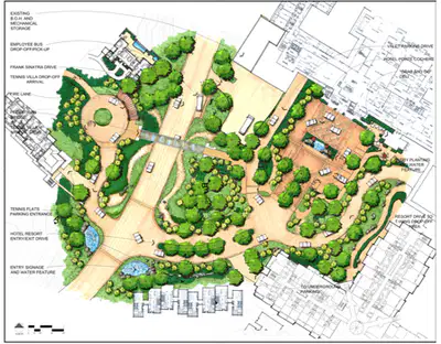
Landscape Architecture
Landscape architecture is the profession and practice of designing, planning, and managing outdoor spaces, combining art, ecology, and engineering to create functional, sustainable, and aesthetically pleasing environments (American Society of Landscape Architects, 2020). It involves shaping land, vegetation, water, and built elements to enhance the quality of human experience while responding to ecological and cultural context.
Core Concepts and Principles
Hardscape vs Softscape: Hardscape refers to man-made elements like pavements, walls, and benches; Softscape refers to living elements like plants, trees, and lawns.
Spatial Organization: Planning circulation paths, open spaces, and functional zones for smooth flow and usability.
Ecological Considerations: Preservation of natural features, water management, and sustainability practices.
Visual and Sensory Experience: Creating pleasing views, focal points, textures, colors, and sensory interactions.
Integration with Architecture: Ensuring harmony between buildings and surrounding landscape.
Human-Centered Design: Providing spaces for recreation, rest, social interaction, and accessibility.
Core Concepts in Site Planning
8
Multiple Choice
Landscape architecture primarily deals with:
Interior design of buildings
Urban and rural outdoor spaces
Engineering of skyscrapers
Architectural theory
9
Multiple Choice
10
Multiple Choice
What is a brownfield?
Abandoned industrial sites
Newly developed areas
Protected natural reserves
Urban parks
11
Multiple Choice
In the Site Planning Process, ________ defines the project’s objectives and functional requirements, including the proposed activities, area allocated for each activity, and the functional or spatial relationships among those activities
Site analysis
Site inventories
Site selection
Programming
12
Multiple Choice
Following are related to landscape architecture except
The arrangement of natural and man-made elements
The application of cultural and scientific knowledge
The art of design, planning, or management of the building
The resultant environment serves useful and enjoyable purpose
13
Multiple Choice
Which of the following is NOT a component of site planning?
Land use allocation
Traffic circulation
Building structural design
Environmental impact assessment
14
Multiple Choice
Use of elevation contour lines to show the shape of the ground surface
World Map
Topographic Map
Cadastral Map
Navigation Chart
15
Multiple Choice
This addresses the visual, audible and tactile aspects of the site
Sensory
Location
Natural Features
Man made features
16
Multiple Choice
The following site attributes are collected during site inventory
Physical, biological and cultural attributes
Ecological, Social and Economic Attributes
Hazards, constraints and nuisances
Legal, organizational and institutional attributes
17
Multiple Choice
During site inventory, we also check for ____________ vis-a-vis physical, biological, and cultural attributes that may influence site selection and or limit site development
Physical, biological and cultural attributes
Ecological, Social and Economic Attributes
Hazards, constraints and nuisances
Legal, organizational and institutional attributes
18
Urban Design
Urban design is the discipline that focuses on the arrangement, appearance, and functionality of towns, cities, and urban spaces. It deals with the design of streets, public spaces, blocks, and neighborhoods, integrating architecture, landscape, and infrastructure to create cohesive, accessible, and vibrant urban environments (Carmona et al., 2010).
Key Elements of Urban Design
Streets and Circulation: Layout of roads, pedestrian paths, and transport networks for accessibility and connectivity
Public Spaces: Plazas, parks, squares, and gathering areas that foster social interaction
Buildings and Blocks: Placement, scale, and form of buildings to define urban character
Land Use and Zoning: Functional organization of residential, commercial, and institutional areas
Edges and Boundaries: Definition of streetscapes, waterfronts, and transitions between urban spaces
Visual and Environmental Quality: Aesthetics, views, sunlight access, and microclimate considerations
Core Concepts in Urban Design and Community Architecture
19
Urban Design History
Urban design has evolved alongside human settlements, reflecting changes in society, technology, and culture. The history of cities highlights how people have organized space to meet social, economic, and environmental needs.
Key Milestones in the History of Cities and Urban Design
Ancient Cities: Cities like Mesopotamia, Mohenjo-Daro, and Athens were planned with streets, markets, and public spaces to support trade, religion, and governance.
Medieval Cities: Narrow, irregular streets with walls for defense; emphasis on community clustering and functional organization.
Renaissance and Baroque Cities: Geometry, symmetry, and monumental streets; planning reflected aesthetics, hierarchy, and power (e.g., Rome, Paris).
Industrial Era Cities: Rapid urbanization, grid layouts, infrastructure challenges, and emergence of zoning to manage density.
Modern and Contemporary Urban Design: Focus on functionality, accessibility, social equity, sustainability, and public realm quality; inclusion of green spaces, mixed-use neighborhoods, and human-centered design.
Core Concepts in Urban Design and Community Architecture
20
Core Theories
Core Concepts in Urban Design and Community Architecture
Elements of a City – Kevin Lynch (1960): Paths, edges, districts, nodes, landmarks; focus on legibility and wayfinding.
Responsive Environments – Ian Bentley et al. (1985):
Urban spaces respond to human activity, perception, and behavior; imageability and human scale.
Urban Morphology – Mumford & Conzen (1960s–70s):
Study of form, structure, and evolution of urban areas; street patterns and building types.
Human-Centered Design / Place-Making – Jan Gehl (1970s–2000s):
Focus on pedestrian experience, social interaction, walkable streets, and vibrant public spaces.
New Urbanism / Smart Growth – Duany & Plater-Zyberk (1980s–90s):
Mixed-use, compact, connected neighborhoods; sustainability and community cohesion.
The Death and Life of Great American Cities – Jane Jacobs (1961):
Diversity, mixed uses, active street life; critique of top-down planning.
Space Syntax Theory – Hillier & Hanson (1984):
Analyzes spatial connectivity and movement patterns to predict human flow.
Imageability & Mental Maps – Kevin Lynch (1960):
How people perceive and navigate cities; use of memorable landmarks and coherent districts.
21
Multiple Choice
The earliest settlement in Israel
khirokitia
eridu
jericho
damascus
22
Multiple Choice
Khirokitia was the earliest settlement in _____.
japan
china
cyprus
turkey
23
Multiple Choice
24
Multiple Choice
25
Multiple Choice
26
Multiple Choice
27
Multiple Choice
28
Multiple Choice
29
Multiple Choice
30
Multiple Choice
31
Multiple Choice
32
Multiple Choice
33
Multiple Choice
34
Urban Planning
Urban planning (also called city planning or town planning in some contexts) is the process of developing and designing land use and the built environment, including air, water, and the infrastructure passing into and out of urban areas, such as transportation, communications, and distribution networks, and their accessibility.
As Defined by RA 10587 (EnP Act of 2013)
Environmental planning, also known as urban and regional planning, city planning, town and country planning, and/or human settlements planning, refers to the multi-disciplinary art and science of analyzing, specifying, clarifying, harmonizing, managing and regulating the use and development of land and water resources, in relation to their environs, for the development of sustainable communities and ecosystems.
Environmental planner refers to a person who is registered and licensed to practice environmental planning and who holds a valid Certificate of Registration and a valid Professional Identification Card from the Board of Environmental Planning and the Professional Regulation Commission.
Core Concepts in Urban and Regional Planning
35
Local Planning Structure
Core Concepts in Urban and Regional Planning
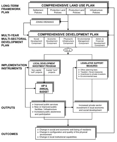
Local Planning Structure in the Philippines is anchored through pertinent planning documents.
Comprehensive Land Use Plan (CLUP) as the spatial framework.
Comprehensive Development Plan (CDP) as the multisectoral plan.
Zoning Ordinance (ZO) as main implementation instrument.
Local Development Investment (LDIP) and Annual Investment Plan (AIP) as implementation tools mapping the project, programs, and activities to LGU resources.
36
Multiple Choice
37
Multiple Choice
38
Multiple Choice
39
Multiple Choice
40
Multiple Choice
41
Multiple Choice
42
Multiple Choice
43
Multiple Choice
44
Multiple Choice
45
Multiple Choice
46
Human Settlements Planning
Human settlements planning refers to the physical organization and management of spaces where people live and interact, encompassing both rural and urban
areas.
It involves the design and organization of communities to ensure safety, security, and well-being, considering factors such as land use, resource distribution, and community needs. The goal is to create environments that promote social cohesion, economic development, and environmental sustainability.
Core Concepts in Human Settlements Planning
Housing
In human settlement planning, housing refers to the physical spaces where people live and interact, encompassing various types of settlements such as rural, urban, and suburban.
As a System
It is a system that includes various components, such as housing production, tenure, and market dynamics, which interact to influence housing demand and supply.
47
RA 9279: Urban Development and Housing Act
RA 7279, also known as the Urban Development and Housing Act of 1992, is a law that provides a comprehensive and continuing program for urban development and housing, with particular focus on addressing the needs of underprivileged and homeless citizens in urban areas.
Key Objectives of RA 7279
~Provide decent housing at affordable cost to underprivileged and homeless citizens
~Promote equitable land use in urban and urbanizable areas
~Encourage balanced urban development and reduce urban congestion
~Strengthen the role of LGUs in urban development and housing delivery
Core Concepts in Human Settlements Planning
Key Provisions
~Prioritizes underprivileged and homeless citizens as primary beneficiaries of government housing programs
~Mandates the provision of socialized housing at affordable cost and in suitable, accessible locations
~Requires LGUs to identify, inventory, and allocate lands for socialized housing within their jurisdictions
~Promotes balanced housing development by requiring private developers to contribute to socialized housing programs
~Authorizes the acquisition of idle, underutilized, or government owned lands for housing purposes
~Encourages participation of the private sector, NGOs, and people’s organizations through incentives and partnerships
~Establishes safeguards for eviction and demolition, including due process, consultation, and adequate relocation
48
Core Theories
Core Concepts in Human Settlements Planning
Human Settlement
A place where people live, work, and interact, including housing, services, infrastructure, and the surrounding environment.
Housing Unit
A structurally separate and independent place of abode intended for habitation by a single household.
Household
A person or group of persons who usually live together in the same housing unit and share common arrangements for food and basic living needs.
Dwelling
A building or part of a building used or intended to be used as a residence, which may contain one or more housing units.
Residential Density
The number of housing units or households within a given land area, commonly expressed as units per hectare.
Tenure
The legal or customary arrangement under which a household occupies a housing unit, such as ownership, rental, or informal occupancy.
Informal Settlement
A residential area where housing units are constructed without secure land tenure, often lacking basic services and formal planning approval.
Slum
A highly congested urban area characterized by substandard housing, poor sanitation, and inadequate access to basic services.
Land Use
The designated function of a parcel of land, such as residential, commercial, institutional, industrial, or open space.
49
50
Multiple Choice
51
Multiple Choice
52
Multiple Choice
53
Multiple Choice
54
Multiple Choice
55
Multiple Choice
56
Multiple Choice
57
Multiple Choice
58
Multiple Choice
59
Multiple Choice
COMPREHENSIVE PLANNING REVIEW
By Andro Madrogaba, UAP, MA - APR Review Center
Show answer
Auto Play
Slide 1 / 59
SLIDE
Similar Resources on Wayground

54 questions
1st, Unit 7, Lesson 6
Presentation
•
KG - Professional Dev...
54 questions
Success 10B
Presentation
•
Professional Development
56 questions
Present continuous
Presentation
•
Professional Development
54 questions
Unit 1 - Practice Lesson
Presentation
•
Professional Development
53 questions
Self-reflection
Presentation
•
Professional Development
53 questions
Tipos de evaluación
Presentation
•
Professional Development
54 questions
Cara Membuat Perpustakaan Digital berintegrasi Mikrosites
Presentation
•
Professional Development
54 questions
Lesson 3 - Beginner - Chị Laura
Presentation
•
KG
Popular Resources on Wayground
6 questions
PRIDE Always and Everywhere
Presentation
•
12th Grade
20 questions
Lab Safety Quiz

Quiz
•
6th Grade
26 questions
KOR Review Kahoot Questions
Quiz
•
8th Grade
21 questions
Continents and Oceans
Quiz
•
6th Grade
12 questions
Unit Zero lesson 2 cafeteria
Presentation
•
9th - 12th Grade
20 questions
Parts of Speech
Quiz
•
5th Grade
10 questions
Riddles Riddles fun Riddles
Quiz
•
6th - 12th Grade
16 questions
Subject & Predicate
Quiz
•
5th Grade
Discover more resources for Architecture
10 questions
Soup, Salad, or Sandwich?
Quiz
•
1st Grade - Professio...
20 questions
Employability Skills
Quiz
•
Professional Development
9 questions
How to Email your Teacher
Quiz
•
Professional Development
25 questions
2023 Pop Culture Trivia
Quiz
•
Professional Development
20 questions
Cinema Camera Angles
Quiz
•
9th Grade - Professio...
20 questions
Sports trivia
Quiz
•
Professional Development
21 questions
Shop Safety
Quiz
•
Professional Development