Intro To ES: Maps
Authored by Marissa Velez
Science
9th - 12th Grade
NGSS covered
Used 15+ times

AI Actions
Add similar questions
Adjust reading levels
Convert to real-world scenario
Translate activity
More...
Content View
Student View
12 questions
Show all answers
1.
MULTIPLE CHOICE QUESTION
30 sec • 1 pt

What is the map symbol (darker lines)?
2.
MULTIPLE CHOICE QUESTION
30 sec • 1 pt

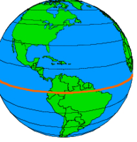
What does this image represent?
Tags
NGSS.MS-ESS2-2
3.
MULTIPLE CHOICE QUESTION
2 mins • 1 pt

Determine the contour interval:
4.
MULTIPLE CHOICE QUESTION
30 sec • 1 pt

What do close contour lines represent on a map?
5.
MULTIPLE CHOICE QUESTION
30 sec • 1 pt
An area's height above sea level
6.
MULTIPLE CHOICE QUESTION
1 min • 1 pt
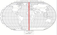
What is the name of the line at zero degrees longitude?
7.
MULTIPLE CHOICE QUESTION
1 min • 1 pt
Latitude and Longitude are measured in______.


Access all questions and much more by creating a free account
Create resources
Host any resource
Get auto-graded reports
Continue with Google

Continue with Email
Continue with Classlink
Continue with Clever
or continue with
Microsoft
%20(1).png)
Apple
Others
Already have an account?
Similar Resources on Wayground

7 questions
Changes around us
Quiz
•
KG - Professional Dev...
15 questions
Acid, Bases and Salt
Quiz
•
10th - 12th Grade
13 questions
INTERACT GENERAL KNOWLEGE TRIVIA
Quiz
•
7th - 12th Grade
15 questions
Pop Science: DNA
Quiz
•
8th - 12th Grade
11 questions
A1 Investigative skills 2
Quiz
•
5th - 9th Grade
15 questions
Midterm Review: U1 Astronomy
Quiz
•
9th - 12th Grade
10 questions
5 minute test
Quiz
•
11th Grade
10 questions
Layers of the Atmosphere Quiz
Quiz
•
7th Grade - University
Popular Resources on Wayground
7 questions
History of Valentine's Day
Interactive video
•
4th Grade
15 questions
Fractions on a Number Line
Quiz
•
3rd Grade
20 questions
Equivalent Fractions
Quiz
•
3rd Grade
25 questions
Multiplication Facts
Quiz
•
5th Grade
22 questions
fractions
Quiz
•
3rd Grade
15 questions
Valentine's Day Trivia
Quiz
•
3rd Grade
20 questions
Main Idea and Details
Quiz
•
5th Grade
20 questions
Context Clues
Quiz
•
6th Grade
Discover more resources for Science
25 questions
Naming Ionic and Covalent Compounds
Quiz
•
9th Grade
20 questions
Mendelian Genetics Review
Quiz
•
9th Grade
10 questions
Exploring Weathering, Erosion, and Deposition Processes
Interactive video
•
6th - 10th Grade
10 questions
Exploring Mendelian Genetics and Punnett Squares
Interactive video
•
6th - 10th Grade
10 questions
Exploring Light and Waves Concepts
Interactive video
•
6th - 10th Grade
20 questions
The Cell Cycle and Mitosis
Quiz
•
9th Grade
35 questions
DNA Structure and Replication
Quiz
•
10th Grade
89 questions
Unit 1 (Ch 2 & 3) Test Review - Water/Ocean Currents
Quiz
•
9th - 12th Grade