US Rivers, Mountains, and Maps
Authored by kristie garnett
Social Studies
2nd - 4th Grade
Used 26+ times

AI Actions
Add similar questions
Adjust reading levels
Convert to real-world scenario
Translate activity
More...
Content View
Student View
18 questions
Show all answers
1.
MULTIPLE CHOICE QUESTION
2 mins • 1 pt
These two rivers flow into the Gulf of Mexico
Mississippi & Rio Grande
Columbia & Hudson Bay
Great Lakes & Missouri
Mississippi & Ohio
2.
MULTIPLE CHOICE QUESTION
2 mins • 1 pt
This river forms the border between the U.S. and Mexico
Colorado
Mississippi
Ohio
Rio Grande
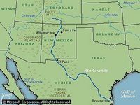
3.
MULTIPLE CHOICE QUESTION
2 mins • 1 pt

What river is highlighted red?
4.
MULTIPLE CHOICE QUESTION
2 mins • 1 pt
What river is highlighted blue?
5.
MULTIPLE CHOICE QUESTION
2 mins • 1 pt

What river is highlighted in blue?
6.
MULTIPLE CHOICE QUESTION
2 mins • 1 pt

What river is highlighted red?
7.
MULTIPLE CHOICE QUESTION
30 sec • 1 pt
The Colorado Rivers begins in the...
Access all questions and much more by creating a free account
Create resources
Host any resource
Get auto-graded reports
Continue with Google

Continue with Email
Continue with Classlink
Continue with Clever
or continue with
Microsoft
%20(1).png)
Apple
Others
Already have an account?
Popular Resources on Wayground

15 questions
Fractions on a Number Line
Quiz
•
3rd Grade
20 questions
Equivalent Fractions
Quiz
•
3rd Grade
25 questions
Multiplication Facts
Quiz
•
5th Grade
29 questions
Alg. 1 Section 5.1 Coordinate Plane
Quiz
•
9th Grade
22 questions
fractions
Quiz
•
3rd Grade
11 questions
FOREST Effective communication
Lesson
•
KG
20 questions
Main Idea and Details
Quiz
•
5th Grade
20 questions
Context Clues
Quiz
•
6th Grade
Discover more resources for Social Studies
26 questions
IA3 Vocabulary Review
Quiz
•
4th Grade
5 questions
Ch5.2 Taking Action for Our Rights
Quiz
•
3rd Grade
15 questions
Natural Disasters Vocabulary
Quiz
•
3rd Grade
13 questions
VS6 A New Nation #1
Quiz
•
4th Grade
10 questions
Juliette Gordon Low
Quiz
•
2nd Grade
15 questions
Understanding Natural Disasters
Quiz
•
3rd Grade
14 questions
New Nation Quiz - Fast and Curious
Quiz
•
4th Grade
26 questions
European Explorers Review
Quiz
•
3rd Grade