Topographic Map
Authored by Sarah Martens
Science
9th - 11th Grade
NGSS covered
Used 42+ times

AI Actions
Add similar questions
Adjust reading levels
Convert to real-world scenario
Translate activity
More...
Content View
Student View
29 questions
Show all answers
1.
FILL IN THE BLANK QUESTION
30 sec • 5 pts
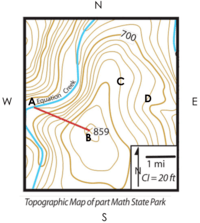
What is the contour interval on this map?
2.
FILL IN THE BLANK QUESTION
30 sec • 5 pts
What letter represents the highest point on this map?
3.
MULTIPLE CHOICE QUESTION
30 sec • 5 pts
What landform is represented at letter B?
hill
mountain
sinkhole
cliff
4.
MULTIPLE CHOICE QUESTION
30 sec • 5 pts
What direction is the river at point A flowing?
West
East
South
North
Tags
NGSS.MS-ESS2-4
5.
MULTIPLE CHOICE QUESTION
30 sec • 5 pts
What do the V-shaped contour lines represent?
earth quake fault
river valley
hiking trail
lava flow
6.
MULTIPLE CHOICE QUESTION
30 sec • 5 pts
What letter represents a steep slope?
A
B
C
D
E
7.
MULTIPLE CHOICE QUESTION
30 sec • 5 pts
What letter represents a gentle slope?
A
B
C
E
F

Access all questions and much more by creating a free account
Create resources
Host any resource
Get auto-graded reports
Continue with Google

Continue with Email
Continue with Classlink
Continue with Clever
or continue with
Microsoft
%20(1).png)
Apple
Others
Already have an account?
Similar Resources on Wayground

24 questions
WOR: Q2 Science 10
Quiz
•
10th Grade
25 questions
SUMMATIVE ASSESSMENT-ONLINE CLASS
Quiz
•
10th Grade
24 questions
Python Quiz for Grade 8
Quiz
•
8th Grade - University
25 questions
Similarity(S.A.S and S.S.S. Similarity)
Quiz
•
9th - 12th Grade
25 questions
SUMMATIVE TEST #4
Quiz
•
10th Grade
25 questions
atmosphere
Quiz
•
5th Grade - University
25 questions
Renewable energies 2n ESO
Quiz
•
9th Grade
25 questions
The motion of particles - Lesson Review
Quiz
•
7th Grade - University
Popular Resources on Wayground
15 questions
Fractions on a Number Line
Quiz
•
3rd Grade
20 questions
Equivalent Fractions
Quiz
•
3rd Grade
25 questions
Multiplication Facts
Quiz
•
5th Grade
54 questions
Analyzing Line Graphs & Tables
Quiz
•
4th Grade
22 questions
fractions
Quiz
•
3rd Grade
20 questions
Main Idea and Details
Quiz
•
5th Grade
20 questions
Context Clues
Quiz
•
6th Grade
15 questions
Equivalent Fractions
Quiz
•
4th Grade
Discover more resources for Science
10 questions
Exploring the Layers of the Earth
Interactive video
•
6th - 10th Grade
25 questions
Naming Ionic and Covalent Compounds
Quiz
•
9th Grade
20 questions
Mendelian Genetics Review
Quiz
•
9th Grade
10 questions
Exploring Weathering, Erosion, and Deposition Processes
Interactive video
•
6th - 10th Grade
21 questions
Evidence of Evolution
Quiz
•
9th Grade
13 questions
Part 3 Review Protein Synthesis and Mutations
Quiz
•
10th Grade
22 questions
Earth's Spheres and Interactions Quiz Reveiw
Quiz
•
8th - 10th Grade
15 questions
Genetics- Punnett Squares
Quiz
•
9th Grade