Exploring Latitude and Longitude Concepts
Interactive Video
•
Science
•
6th - 10th Grade
•
Practice Problem
•
Medium
Standards-aligned

Jackson Turner
Used 141+ times
FREE Resource
Standards-aligned
Read more
10 questions
Show all answers
1.
MULTIPLE CHOICE QUESTION
30 sec • 1 pt
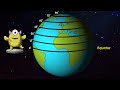
What is the longest line of latitude called?
Arctic Circle
Prime Meridian
Equator
Tropic of Cancer
2.
MULTIPLE CHOICE QUESTION
30 sec • 1 pt
How are latitudes north of the equator measured?
In hours
In degrees from 0 to 180
In degrees from 1 to 90
In negative numbers
3.
MULTIPLE CHOICE QUESTION
30 sec • 1 pt
Which latitude line is known as the Tropic of Capricorn?
23.5 degrees North
23.5 degrees South
66.5 degrees North
0 degrees
4.
MULTIPLE CHOICE QUESTION
30 sec • 1 pt
What is the area between the Tropic of Cancer and the Tropic of Capricorn called?
Temperate Zone
Polar Zone
Desert Zone
Tropical Zone
Tags
NGSS.MS-ESS2-6
5.
MULTIPLE CHOICE QUESTION
30 sec • 1 pt
What is the central line of longitude called?
Equator
Prime Meridian
Tropic of Cancer
International Date Line
6.
MULTIPLE CHOICE QUESTION
30 sec • 1 pt
How are longitudes west of the prime meridian measured?
In negative numbers
In positive numbers
In degrees from 0 to 90
In hours
7.
MULTIPLE CHOICE QUESTION
30 sec • 1 pt
How many degrees of longitude correspond to a one-hour time difference?
45 degrees
30 degrees
15 degrees
10 degrees
Access all questions and much more by creating a free account
Create resources
Host any resource
Get auto-graded reports
Continue with Google

Continue with Email
Continue with Classlink
Continue with Clever
or continue with
Microsoft
%20(1).png)
Apple
Others
Already have an account?
