Geospatial Technology and Its Applications
Interactive Video
•
Science, Geography, Social Studies
•
9th - 12th Grade
•
Practice Problem
•
Hard

Emma Peterson
FREE Resource
Read more
10 questions
Show all answers
1.
MULTIPLE CHOICE QUESTION
30 sec • 1 pt
Why is it important to use geospatial technologies for decision-making?
They provide anecdotal information.
They offer quantified and explicit data.
They are cheaper than other technologies.
They are easier to use than traditional maps.
2.
MULTIPLE CHOICE QUESTION
30 sec • 1 pt
What is one of the main uses of geospatial technology in climate studies?
Predicting earthquakes
Monitoring ice sheet changes
Tracking animal migrations
Forecasting volcanic eruptions
3.
MULTIPLE CHOICE QUESTION
30 sec • 1 pt
How does geospatial technology help in addressing food insecurity?
By increasing food production
By reducing food prices
By monitoring crop production and drought impact
By predicting future food trends
4.
MULTIPLE CHOICE QUESTION
30 sec • 1 pt
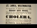
What historical event is an early example of using mapping for disease tracking?
The Black Death in Europe
The Spanish Flu pandemic
John Snow's cholera map in London
The Ebola outbreak in Africa
5.
MULTIPLE CHOICE QUESTION
30 sec • 1 pt
During the Hajj pilgrimage, how was geospatial technology used to manage health concerns?
By banning pilgrims from certain countries
By tracking disease spread in real-time
By providing free healthcare to all pilgrims
By reducing the number of pilgrims allowed
6.
MULTIPLE CHOICE QUESTION
30 sec • 1 pt
What is a key benefit of geospatial technology in public health?
It reduces healthcare costs
It allows for real-time disease tracking
It eliminates the need for vaccines
It provides free healthcare services
7.
MULTIPLE CHOICE QUESTION
30 sec • 1 pt
What was the main goal of the mapping project in Kibera, Kenya?
To evict residents from the slum
To provide government data for development
To create a tourist map of the area
To empower residents with information
Access all questions and much more by creating a free account
Create resources
Host any resource
Get auto-graded reports
Continue with Google

Continue with Email
Continue with Classlink
Continue with Clever
or continue with
Microsoft
%20(1).png)
Apple
Others
Already have an account?
Popular Resources on Wayground

7 questions
History of Valentine's Day
Interactive video
•
4th Grade
15 questions
Fractions on a Number Line
Quiz
•
3rd Grade
20 questions
Equivalent Fractions
Quiz
•
3rd Grade
25 questions
Multiplication Facts
Quiz
•
5th Grade
22 questions
fractions
Quiz
•
3rd Grade
15 questions
Valentine's Day Trivia
Quiz
•
3rd Grade
20 questions
Main Idea and Details
Quiz
•
5th Grade
20 questions
Context Clues
Quiz
•
6th Grade
Discover more resources for Science
25 questions
Naming Ionic and Covalent Compounds
Quiz
•
9th Grade
20 questions
Mendelian Genetics Review
Quiz
•
9th Grade
10 questions
Exploring Weathering, Erosion, and Deposition Processes
Interactive video
•
6th - 10th Grade
10 questions
Exploring Mendelian Genetics and Punnett Squares
Interactive video
•
6th - 10th Grade
10 questions
Exploring Light and Waves Concepts
Interactive video
•
6th - 10th Grade
20 questions
The Cell Cycle and Mitosis
Quiz
•
9th Grade
35 questions
DNA Structure and Replication
Quiz
•
10th Grade
89 questions
Unit 1 (Ch 2 & 3) Test Review - Water/Ocean Currents
Quiz
•
9th - 12th Grade