Geological Boundary Analysis Techniques
Interactive Video
•
Science, Geography
•
10th - 12th Grade
•
Practice Problem
•
Hard

Ethan Morris
FREE Resource
Read more
10 questions
Show all answers
1.
MULTIPLE CHOICE QUESTION
30 sec • 1 pt
What is the primary objective of the exercise described in the video?
To understand the history of geological formations
To study the effects of erosion on landscapes
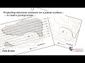
To analyze a geological boundary using structured contours
To learn how to draw topographic maps
2.
MULTIPLE CHOICE QUESTION
30 sec • 1 pt
In the qualitative analysis, what pattern indicates the geological boundary dips southwards?
A straight line
A zigzag pattern
A V shape in the valley
A circular pattern
3.
MULTIPLE CHOICE QUESTION
30 sec • 1 pt
What is the purpose of constructing structure contours in the exercise?
To measure the height of mountains
To identify water bodies on the map
To predict the subsurface and forecast the depth of the geological boundary
To create a 3D model of the landscape
4.
MULTIPLE CHOICE QUESTION
30 sec • 1 pt
How is the depth of the geological boundary in the borehole determined?
By estimating based on visual inspection
By measuring the width of the valley
By calculating the distance from the hilltop
By using the elevation of structure contours
5.
MULTIPLE CHOICE QUESTION
30 sec • 1 pt
What is the significance of parallel structure contours in the dip direction?
They suggest multiple geological boundaries
They confirm the boundary is ideally planar
They show the boundary is non-planar
They indicate a curved geological boundary
6.
MULTIPLE CHOICE QUESTION
30 sec • 1 pt
What trigonometric function is used to calculate the dip of the geological boundary?
Sine
Cosine
Tangent
Cotangent
7.
MULTIPLE CHOICE QUESTION
30 sec • 1 pt
What is the calculated dip of the geological boundary?
5 degrees
9 degrees
20 degrees
15 degrees
Access all questions and much more by creating a free account
Create resources
Host any resource
Get auto-graded reports
Continue with Google

Continue with Email
Continue with Classlink
Continue with Clever
or continue with
Microsoft
%20(1).png)
Apple
Others
Already have an account?
Popular Resources on Wayground

15 questions
Fractions on a Number Line
Quiz
•
3rd Grade
20 questions
Equivalent Fractions
Quiz
•
3rd Grade
25 questions
Multiplication Facts
Quiz
•
5th Grade
54 questions
Analyzing Line Graphs & Tables
Quiz
•
4th Grade
22 questions
fractions
Quiz
•
3rd Grade
20 questions
Main Idea and Details
Quiz
•
5th Grade
20 questions
Context Clues
Quiz
•
6th Grade
15 questions
Equivalent Fractions
Quiz
•
4th Grade
Discover more resources for Science
10 questions
Exploring the Layers of the Earth
Interactive video
•
6th - 10th Grade
10 questions
Exploring Weathering, Erosion, and Deposition Processes
Interactive video
•
6th - 10th Grade
13 questions
Part 3 Review Protein Synthesis and Mutations
Quiz
•
10th Grade
22 questions
Earth's Spheres and Interactions Quiz Reveiw
Quiz
•
8th - 10th Grade
35 questions
DNA Structure and Replication
Quiz
•
10th Grade
20 questions
Phylogenetic Trees and Cladograms
Quiz
•
10th Grade
15 questions
Chemical Reactions (Types of Chemical Reactions)
Interactive video
•
11th Grade
89 questions
Unit 1 (Ch 2 & 3) Test Review - Water/Ocean Currents
Quiz
•
9th - 12th Grade