Trigonometric Functions and Satellite Distances
Interactive Video
•
Mathematics, Physics
•
9th - 12th Grade
•
Practice Problem
•
Hard

Lucas Foster
FREE Resource
Read more
10 questions
Show all answers
1.
MULTIPLE CHOICE QUESTION
30 sec • 1 pt
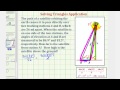
What is the distance between the two tracking stations A and B?
83.5 miles
93.1 miles
86.9 miles
56 miles
2.
MULTIPLE CHOICE QUESTION
30 sec • 1 pt
What are the angles of elevation at stations A and B?
86.9° and 83.5°
90° and 45°
60° and 30°
75° and 15°
3.
MULTIPLE CHOICE QUESTION
30 sec • 1 pt
What is the complementary angle to the angle of elevation at station A?
3.1°
4.5°
6.5°
5.5°
4.
MULTIPLE CHOICE QUESTION
30 sec • 1 pt
What is the measure of the angle opposite to the side of known length in the obtuse triangle?
86.9°
83.5°
93.1°
3.4°
5.
MULTIPLE CHOICE QUESTION
30 sec • 1 pt
Which trigonometric law is used to find the distance from station A?
Law of Cosines
Law of Sines
Law of Tangents
Pythagorean Theorem
6.
MULTIPLE CHOICE QUESTION
30 sec • 1 pt
What is the approximate distance of the satellite from station A?
93818 miles
90000 miles
56000 miles
83000 miles
7.
MULTIPLE CHOICE QUESTION
30 sec • 1 pt
Which trigonometric function is used to find the height of the satellite?
Cosine
Sine
Tangent
Cotangent
Access all questions and much more by creating a free account
Create resources
Host any resource
Get auto-graded reports
Continue with Google

Continue with Email
Continue with Classlink
Continue with Clever
or continue with
Microsoft
%20(1).png)
Apple
Others
Already have an account?
