LAH 3.1 Map Skills
Authored by Lisa C.
Social Studies
9th - 12th Grade
Used 16+ times

AI Actions
Add similar questions
Adjust reading levels
Convert to real-world scenario
Translate activity
More...
Content View
Student View
31 questions
Show all answers
1.
MULTIPLE CHOICE QUESTION
30 sec • 1 pt

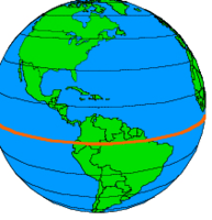
This imaginary line divides the Earth into Northern and Southern Hemisphere. It is called the ________________.
2.
MULTIPLE CHOICE QUESTION
30 sec • 1 pt

This imaginary line is called the ______________. It divides the globe into Eastern and Western hemispheres.
Equator
Divider
Prime Factor
Prime Meridian
3.
DRAG AND DROP QUESTION
1 min • 3 pts
Latitude lines are the lines on the map that are (a) . Latitude lines run (b) BUT measure how far (c) you are from the equator.
4.
DRAG AND DROP QUESTION
1 min • 3 pts
Longitude lines are the lines on the map that are (a) . Longitude lines run (b) BUT measure how far (c) you are from the equator.
5.
MULTIPLE CHOICE QUESTION
30 sec • 1 pt

What does this image show?
The image shows the lines of longitude.
The image shows the lines of latitude.
The image shows how to get to the North and South Poles.
All of these are correct answers
6.
MULTIPLE CHOICE QUESTION
30 sec • 1 pt
What does the image show?
The image shows lines of longitude.
The image shows lines of latitude.
The image ONLY shows the equator.
The image shows major trade routes.
7.
MULTIPLE CHOICE QUESTION
30 sec • 1 pt

Which hemisphere is located above the equator?
Northern
Southern
Eastern
Western


Access all questions and much more by creating a free account
Create resources
Host any resource
Get auto-graded reports
Continue with Google

Continue with Email
Continue with Classlink
Continue with Clever
or continue with
Microsoft
%20(1).png)
Apple
Others
Already have an account?
