Exploring Types of Maps for Middle Schoolers
Interactive Video
•
Social Studies
•
6th - 10th Grade
•
Practice Problem
•
Medium

Sophia Harris
Used 27+ times
FREE Resource
Read more
10 questions
Show all answers
1.
MULTIPLE CHOICE QUESTION
30 sec • 1 pt
What is the primary purpose of a political map?
To show physical features like mountains and rivers
To indicate population density
To display the boundaries of different governments
To show transportation routes
2.
MULTIPLE CHOICE QUESTION
30 sec • 1 pt
Which of the following is NOT typically shown on a political map?
State boundaries
Country boundaries
Mountain ranges
County lines
3.
MULTIPLE CHOICE QUESTION
30 sec • 1 pt
What do physical maps primarily display?
Political boundaries
Physical attributes like rivers and mountains
Population density
Transportation routes
4.
MULTIPLE CHOICE QUESTION
30 sec • 1 pt
How can physical maps help us understand the geological creation of an area?
By indicating the population density
By showing the boundaries of different countries
By displaying the physical features and formations like lava flows
By showing transportation routes
5.
MULTIPLE CHOICE QUESTION
30 sec • 1 pt
What is the main feature of topographical maps?
Physical attributes
Transportation routes
Political boundaries
Contour lines showing elevation
6.
MULTIPLE CHOICE QUESTION
30 sec • 1 pt
Who would find topographical maps most useful?
City planners
Economists
Pilots
Hikers and campers
7.
MULTIPLE CHOICE QUESTION
30 sec • 1 pt
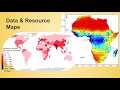
What type of information do data and resource maps provide?
Political boundaries
Transportation routes
Various types of data like precipitation and birth rates
Physical attributes
Access all questions and much more by creating a free account
Create resources
Host any resource
Get auto-graded reports
Continue with Google

Continue with Email
Continue with Microsoft
or continue with

%20(1).png)
Apple
Others
Already have an account?
