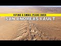
Soda Lake and San Andreas Fault
Interactive Video
•
Science, Geography, History
•
6th - 10th Grade
•
Practice Problem
•
Hard

Jackson Turner
FREE Resource
Read more
10 questions
Show all answers
1.
MULTIPLE CHOICE QUESTION
30 sec • 1 pt
What was the magnitude of the Fort Tejon earthquake that occurred in 1857?
8.2
7.9
7.0
6.5
2.
MULTIPLE CHOICE QUESTION
30 sec • 1 pt
Which two tectonic plates does the San Andreas Fault separate?
Eurasian and African
Pacific and North American
Indian and Australian
South American and Antarctic
3.
MULTIPLE CHOICE QUESTION
30 sec • 1 pt
How much does the San Andreas Fault move on average each year?
0.5 inches
1.3 inches
2.0 inches
3.5 inches
4.
MULTIPLE CHOICE QUESTION
30 sec • 1 pt
Where is the Carrizo Plain located in relation to Los Angeles?
150 miles northeast
100 miles northwest
50 miles southeast
200 miles southwest
5.
MULTIPLE CHOICE QUESTION
30 sec • 1 pt
What visual feature does the San Andreas Fault create in the landscape?
A deep canyon
A circular crater
A linear valley
A mountain peak
6.
MULTIPLE CHOICE QUESTION
30 sec • 1 pt
What is the significance of the Carrizo Plain in understanding the San Andreas Fault?
It provides a clear view of the tectonic plate boundary
It is the deepest part of the fault
It has the oldest geological formations
It is the site of the largest earthquake
7.
MULTIPLE CHOICE QUESTION
30 sec • 1 pt
How far has Wallace Creek been offset due to the fault's movement?
520 feet
420 feet
320 feet
200 feet
Access all questions and much more by creating a free account
Create resources
Host any resource
Get auto-graded reports
Continue with Google

Continue with Email
Continue with Microsoft
or continue with

%20(1).png)
Apple
Others
Already have an account?
