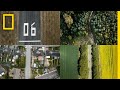
Exploring the UK's Land Use
Interactive Video
•
Geography, Science, Biology
•
6th - 10th Grade
•
Practice Problem
•
Hard

Olivia Brooks
FREE Resource
Read more
7 questions
Show all answers
1.
MULTIPLE CHOICE QUESTION
30 sec • 1 pt
What is the purpose of the 100-second walk across the UK?
To explore historical sites
To measure the length of the UK
To understand the proportion of different land types
To calculate the population density
2.
MULTIPLE CHOICE QUESTION
30 sec • 1 pt
Which type of land occupies 5% of the UK?
Natural grasslands
Houses and gardens
Peat bogs
Forests
3.
MULTIPLE CHOICE QUESTION
30 sec • 1 pt
What percentage of the UK is covered by peat bogs and similar lands?
9%
5%
15%
20%
4.
MULTIPLE CHOICE QUESTION
30 sec • 1 pt
What is the primary use of the fields of crops in the UK?
Feeding livestock
Exporting to other countries
Producing biofuels
Growing exotic plants
5.
MULTIPLE CHOICE QUESTION
30 sec • 1 pt
Which crop is NOT mentioned as being grown in the UK?
Rice
Oats
Barley
Wheat
6.
MULTIPLE CHOICE QUESTION
30 sec • 1 pt
What is the largest single use of land in the UK?
Peat bogs
Pastures for cows and sheep
Urban development
Forests
7.
MULTIPLE CHOICE QUESTION
30 sec • 1 pt
What environmental concern is highlighted in the video?
Risk of species extinction
Overpopulation
Air pollution
Deforestation
Access all questions and much more by creating a free account
Create resources
Host any resource
Get auto-graded reports
Continue with Google

Continue with Email
Continue with Microsoft
or continue with

%20(1).png)
Apple
Others
Already have an account?
